Independence Park (Charlotte, North Carolina)

Last updated
Independence Park
Stone shelter in Independence Park, Charlotte, NC.jpg
Independence Park (Charlotte, North Carolina)
TypePublic park
Location Charlotte, North Carolina
Coordinates 35°12′56″N80°49′21″W / 35.2155°N 80.8224°W / 35.2155; -80.8224
Area24 acres
Created1904
Operated by Mecklenburg County Parks and Recreation
Website Independence Park

Independence Park is a 24-acre urban park at 300 Hawthorne Lane situated at the western end of the Elizabeth neighborhood in Charlotte, North Carolina. The park was created in 1924 at the urging of Charlotte industrialist Daniel Augustus Tompkins, founder of the Charlotte Observer , and is the oldest public park in Charlotte. [1] It reopened in August 2023 after being closed for renovations that enhance accessibility and add permanent restrooms, among other improvements. [2]

Contents

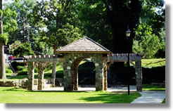
Independence Park is split into two sections by Hawthorne Lane. Both sections lie below street level which gives the park a secluded and tranquil atmosphere, despite the fact that the site commands excellent views of the Charlotte skyline. The lower park contains a winding path, a rose garden, large, leafy trees, a reflecting pond, and a gazebo. The upper park contains more trails, a playground, several athletic fields, and the 300 seat Independence Park Stadium. [1] [3]

Independence Park is the site in Charlotte of the Afro-Caribbean themed Juneteenth Festival of the Carolinas on June 19 of each year. [4]

Arhelger Memorial

In June 1931 a group of Girl Scouts from Charlotte was visiting Glen Burney Falls in Blowing Rock, North Carolina. One girl fell into the falls, and 21-year-old counselor Lillian Arhelger lost her life when she jumped in to save her. A memorial to the fallen hero was erected, and today the bronze and stone Lillian Arhelger Memorial, with its reflecting pool, is a prominent feature in the upper half of Independence Park. [5]

Related Research Articles

<span class="mw-page-title-main">Charlotte, North Carolina</span> Largest city in North Carolina

Charlotte is the most populous city in the U.S. state of North Carolina. Located in the Piedmont region, it is the county seat of Mecklenburg County. The population was 874,579 at the 2020 census, making Charlotte the 15th-most populous city in the United States, the seventh-most populous city in the South, and the second-most populous city in the Southeast behind Jacksonville, Florida. The city is the cultural, economic, and transportation center of the Charlotte metropolitan area, whose 2020 population of 2,660,329 ranked 22nd in the United States. Metrolina is part of a sixteen-county market region or combined statistical area with a 2020 population of 2,822,352.

<span class="mw-page-title-main">Juneteenth</span> US holiday commemorating the emancipation of enslaved people

Juneteenth is a federal holiday in the United States commemorating the end of slavery. Its name is a portmanteau of the words "June" and "nineteenth", as it is celebrated on the anniversary of June 19, 1865, when as the American Civil War was ending, Major General Gordon Granger ordered the final enforcement of the Emancipation Proclamation in Texas. Originating in Galveston, Juneteenth has since been observed annually in various parts of the United States, often broadly celebrating African-American culture.

<span class="mw-page-title-main">Letchworth State Park</span> State park in New York state, United States

Letchworth State Park is a 14,427-acre (5,838 ha) New York State Park located in Livingston County and Wyoming County in the western part of the State of New York. The park is roughly 17 miles (27 km) long, following the course of the Genesee River as it flows north through a deep gorge and over several large waterfalls. It is located 35 miles (56 km) southwest of Rochester and 60 miles (97 km) southeast of Buffalo, and spans portions of the Livingston County towns of Leicester, Mount Morris and Portage, as well as the Wyoming County towns of Castile and Genesee Falls.

<span class="mw-page-title-main">Mecklenburg County, North Carolina</span> County in North Carolina, United States

Mecklenburg County is a county located in the southwestern region of the state of North Carolina, in the United States. As of the 2020 census, the population was 1,115,482, making it the second-most populous county in North Carolina and the first county in the Carolinas to surpass one million in population. Its county seat is Charlotte, the state's largest community.

<span class="mw-page-title-main">Interstate 485</span> Beltway around Charlotte, NC

Interstate 485 (I-485) is a 66.68-mile-long (107.31 km) auxiliary Interstate Highway encircling Charlotte, North Carolina. As a complete loop, it is primarily signed with "inner" and "outer" designations, though at some major interchanges, supplemental signage reflects the local compass orientation of the road. The entire route lies within Mecklenburg County.

<span class="mw-page-title-main">Carowinds</span> Amusement park

Carowinds is a 407-acre (165 ha) amusement park primarily located in Charlotte, North Carolina. Owned and operated by Cedar Fair, the park opened to the public on March 31, 1973. Carowinds straddles the state line between North and South Carolina, adjacent to Interstate 77, with a portion of the park located in Fort Mill, South Carolina. It was constructed at a cost of $70 million following a four-year planning period led by Charlotte businessman Earl Patterson Hall. Carowinds also features Carolina Harbor, a 27-acre (11 ha) water park that is included with park admission. Annual events include the Halloween-themed S-Carowinds and the Christmas-themed WinterFest.

<span class="mw-page-title-main">American Legion Memorial Stadium</span> Stadium in Charlotte, North Carolina, USA

American Legion Memorial Stadium is a 10,500-seat stadium located on 7th Street in the Elizabeth community of Charlotte, North Carolina. It is located on a complex with the Grady Cole Center. Both are located next to Central Piedmont Community College. Independence Park Stadium, a tiny public baseball stadium, is also close by. Memorial Stadium is mainly used for high school sporting events and also serves as a public venue. Before the construction of nearby Bank of America Stadium in 1996, Memorial Stadium was Charlotte's largest outdoor stadium, and is still the largest municipal venue in the city.

<span class="mw-page-title-main">Salem Parkway (North Carolina)</span>

The Salem Parkway is an 18.5-mile-long (29.8 km) freeway in the U.S. state of North Carolina, serving the city of Winston-Salem and the town of Kernersville. It is signed as U.S. Route 421 (US 421) for its entire length, though it is also concurrent with US 158 in downtown Winston-Salem and North Carolina Highway 150 (NC 150) between Winston-Salem and Kernersville. Originally known as the East–West Expressway, it was designated as part of Interstate 40 (I-40) and opened in 1958, becoming the first section of Interstate Highway in the state. I-40 was rerouted onto a new alignment bypassing Winston-Salem and Kernersville in 1992, at which time the road was designated Interstate 40 Business, nicknamed Business 40.

<span class="mw-page-title-main">North Carolina Highway 16</span> State highway in North Carolina, US

North Carolina Highway 16 (NC 16) is a 143.8-mile primary state highway in the U.S. state of North Carolina. Traveling in a north–south direction, it connects the cities and towns of Charlotte, Newton, Conover, Taylorsville, Wilkesboro and Jefferson, linking the Charlotte metropolitan area with the mountainous High Country. NC 16 is part of a three-state route 16 that connects the Charlotte region with northwestern West Virginia.

The Land of Oz is a theme park based on L. Frank Baum's Land of Oz books, located in the resort town of Beech Mountain, North Carolina, US. Carolina Caribbean Corporation opened it in 1970 under the guidance of Grover Robbins, who had been successful with Tweetsie Railroad. Designed by Jack Pentes, the park was fully operational until 1980. As of September 2019, it now opens for Fridays in June for "Journey with Dorothy Tours" and in September for Autumn at Oz – the largest Wizard of Oz festival in the country.

<span class="mw-page-title-main">Interstate 77 in North Carolina</span> Highway in North Carolina

Interstate 77 (I-77) is a part of the Interstate Highway System that runs from Columbia, South Carolina, to Cleveland, Ohio. In North Carolina, I-77 enters the state at Charlotte, from South Carolina. Crossing the Piedmont, it connects with Statesville before continuing north into Virginia. The landscapes traversed by I-77 is a contrast of urban and rural foothills, with views of the Blue Ridge Mountains seen from a distance on its most northern section. The Interstate extends for 105.7 miles (170.1 km) and has one auxiliary route.

<span class="mw-page-title-main">Interstate 85 in North Carolina</span> Section of Interstate Highway in North Carolina, United States

Interstate 85 (I-85) is an Interstate Highway that runs from Montgomery, Alabama, to Petersburg, Virginia. In North Carolina, I-85 travels 231.23 miles (372.13 km) from the South Carolina state line near Grover, North Carolina, to the Virginia state line near Wise. Despite being signed north–south, I-85 physically travels in a southwest–northeast direction across the state. The Interstate Highway connects the three most populous metropolitan areas of North Carolina: the Charlotte metropolitan area, Piedmont Triad, and Research Triangle, as well as nine of the 20 largest municipalities in the state. Outside of North Carolina, I-85 connects the state with Richmond, Virginia, to the north and Upstate South Carolina and Atlanta, Georgia, to the south. I-85 parallels several US Highways including US Highway 29 (US 29) between South Carolina and Greensboro, US 70 between Greensboro and Durham, US 15 between Durham and Oxford, and US 1 between Henderson and Virginia.

<span class="mw-page-title-main">Interstate 77 in South Carolina</span> Highway in South Carolina

Interstate 77 (I-77) is a south–north Interstate Highway, extending 91.2 miles (146.8 km) in the state of South Carolina, from the national southern terminus at an interchange with I-26 near Columbia, north to the North Carolina state line near Rock Hill and Charlotte, North Carolina.

<span class="mw-page-title-main">Elizabeth (Charlotte neighborhood)</span> Historic district in North Carolina, United States

Elizabeth takes its name from Elizabeth College, a small Lutheran women's college founded in 1897 on the present-day site of Presbyterian Hospital. The community began in 1891 when a streetcar was established along East Trade Street to the area, making it the second oldest streetcar suburb in Charlotte. Elizabeth began to develop rapidly after 1902, when a trolley line was completed, and was annexed in 1907. Home of Independence Park, the first public park in the city, Elizabeth became one of the most fashionable residential areas in Charlotte in its early days. In 2006 Elizabeth had a population of 3,908.

<span class="mw-page-title-main">U.S. Route 221 in North Carolina</span> Segment of American highway

In the U.S. state of North Carolina U.S. Route 221 (US 221) is a north–south highway that travels through Western North Carolina. From Chesnee, South Carolina to Independence, Virginia, it connects the cities of Rutherfordton, Marion, Boone and Jefferson between the two out-of-state destinations. Its most memorable section, known as the Little Parkway Scenic Byway between Linville and Blowing Rock, offers area visitors a curvier alternative to the Blue Ridge Parkway and access to Grandfather Mountain.

<span class="mw-page-title-main">Latta Place</span> Historic house in North Carolina, United States

Latta Place, also known as Latta House, is a historic house located in Huntersville, North Carolina near Mountain Island Lake. Built in about 1800 in a Federal style, the plantation also contains some elements of Georgian design, including the house's main staircase.

<span class="mw-page-title-main">Charlotte Independence</span> American professional soccer team in Charlotte, North Carolina

Charlotte Independence is an American soccer team based in Charlotte, North Carolina that plays in the USL League One, the third tier of the American soccer pyramid.

<span class="mw-page-title-main">Elizabeth & Hawthorne station</span> Streetcar station in Charlotte, North Carolina.

Elizabeth & Hawthorne is a streetcar station in Charlotte, North Carolina. The at-grade dual side platforms on Elizabeth Avenue are a stop along the CityLynx Gold Line and serves the Elizabeth neighborhood.

<span class="mw-page-title-main">Hawthorne & 5th station</span> Streetcar station in Charlotte, North Carolina.

Hawthorne & 5th is a streetcar station in Charlotte, North Carolina. The at-grade island platform on Hawthorne Lane is a stop along the CityLynx Gold Line and serves Novant Health Presbyterian Medical Center and the Elizabeth neighborhood.

<span class="mw-page-title-main">Hawthorne & 8th station</span> Streetcar station in Charlotte

Hawthorne & 8th is a streetcar station in Charlotte, North Carolina. The at-grade island platform on Hawthorne Lane is a stop along the CityLynx Gold Line, serving the Elizabeth neighborhood.

References

  1. 1 2 Historic Landmarks Commission: Survey and Research Report on Independence Park
  2. "Charlotte's first public park reopens soon after a nearly $6 million makeover". August 24, 2022.
  3. Mecklenburg County Park and Recreation: Independence Park
  4. Welcome to Juneteenth Festival of the Carolinas
  5. Story and photos of the Arhelger Memorial