
The Northern Territory is an Australian territory in the central and central northern regions of Australia. The Northern Territory shares its borders with Western Australia to the west, South Australia to the south, and Queensland to the east. To the north, the territory looks out to the Timor Sea, the Arafura Sea and the Gulf of Carpentaria, including Western New Guinea and other islands of the Indonesian archipelago.
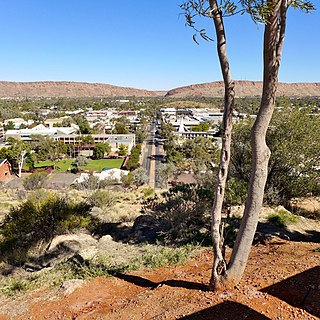
Alice Springs is a town in the Northern Territory, Australia; the third largest settlement after Darwin and Palmerston. The name Alice Springs was given by surveyor William Whitfield Mills after Alice, Lady Todd, wife of the telegraph pioneer Sir Charles Todd. Known colloquially as "The Alice" or simply "Alice", the town is situated roughly in Australia's geographic centre. It is nearly equidistant from Adelaide and Darwin.
Kintore is a remote settlement in the Kintore Range of the Northern Territory of Australia about 530 km (330 mi) west of Alice Springs and 40 km (25 mi) from the border with Western Australia. It is also known as Walungurru, Walangkura, and Walangura.
Tarcoola is a town in the Far North of South Australia 416 kilometres (258 mi) north-northwest of Port Augusta. At the 2016 census, Tarcoola had no people living within its boundaries.

The Alice Springs Town Council is a local government area in the Northern Territory. On 1 July 1971, Alice Springs was gazetted as a Municipality with the town council elected on 25 July 1971. It is situated 1,498 kilometres (931 mi) south of Darwin. The council governs an area of 328 square kilometres (127 sq mi) and had a population of 26,534 in June 2018.
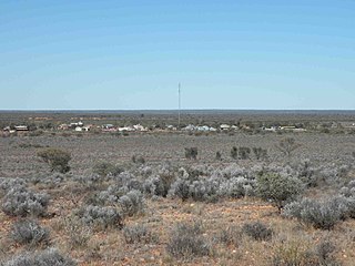
Kiwirrkurra, gazetted as Kiwirrkurra Community, is a small community in Western Australia in the Gibson Desert, 1,200 kilometres (750 mi) east of Port Hedland and 700 kilometres (430 mi) west of Alice Springs. It had a population of 165 in 2016, mostly Aboriginal Australians. It has been described as the most remote community in Australia.
Gillen is a suburb of the town of Alice Springs in the Northern Territory, Australia. It is on the traditional Country of the Arrernte people.
Larapinta is an outer suburb of the town of Alice Springs, in the Northern Territory, Australia. It is on the western side of Alice Springs, on the traditional Country of the Arrernte people.
Irlpme is a outer suburb of the town of Alice Springs, in the Northern Territory, Australia. It is on the traditional Country of the Arrernte people.
Ilparpa is an outer suburb of the town of Alice Springs, in the Northern Territory, Australia. It is on the traditional Country of the Arrernte people.
Flynn is an outer suburb of the town of Alice Springs, in the Northern Territory, Australia. It is on the traditional Country of the Arrernte people.
East Side is a suburb of the town of Alice Springs, in the Northern Territory, Australia. It is on the traditional Country of the Arrernte people.
Stuart is a suburb of the town of Alice Springs, in the Northern Territory, Australia. It is on the traditional Country of the Arrernte people.
Ross is an outer suburb of the town of Alice Springs, in the Northern Territory, Australia. It is on the traditional Country of the Arrernte people.
Arumbera is an outer suburb of the town of Alice Springs, in the Northern Territory, Australia. It is on the traditional Country of the Arrernte people.
White Gums is an outer suburb of the town of Alice Springs, in the Northern Territory, Australia. It is on the traditional Country of the Arrernte people.
Undoolya is an outer suburb of the town of Alice Springs, in the Northern Territory, Australia. It is on the traditional Country of the Arrernte people.

The Gap is a suburb of the town of Alice Springs, in the Northern Territory, Australia. It is located at the Heavitree Gap. It is on the traditional Country of the Arrernte people.
Sadadeen is a suburb of the town of Alice Springs, in the Northern Territory, Australia. It is on the traditional Country of the Arrernte people.
Yuelamu, also known as Mount Allan, Mount Allen, Alpirakina, and Alpirakinga, is a small town in the Northern Territory, Australia, located 298 kilometres (185 mi) north-west of Alice Springs, Its altitude is 687.1 metres (2,254 ft).

