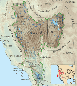
The Great Basin is the largest area of contiguous endorheic watersheds, those with no outlets to the ocean, in North America. It spans nearly all of Nevada, much of Utah, and portions of California, Idaho, Oregon, Wyoming, and Baja California. It is noted for both its arid climate and the basin and range topography that varies from the North American low point at Badwater Basin in Death Valley to the highest point of the contiguous United States, less than 100 miles (160 km) away at the summit of Mount Whitney. The region spans several physiographic divisions, biomes, ecoregions, and deserts.

Owens Valley is an arid valley of the Owens River in eastern California in the United States. It is located to the east of the Sierra Nevada, west of the White Mountains and Inyo Mountains, and is within the northern end of the Mojave Desert. It sits on the west edge of the Great Basin. The mountain peaks on the West side reach above 14,000 feet (4,300 m) in elevation, while the floor of the Owens Valley is about 4,000 feet (1,200 m), making the valley the deepest in the United States. The Sierra Nevada casts the valley in a rain shadow, which makes Owens Valley "the Land of Little Rain". The bed of Owens Lake, now a predominantly dry endorheic alkali flat, sits on the southern end of the valley.

The East Walker River is an approximately 90 miles (140 km) long, tributary of the Walker River, in eastern California and western Nevada in the United States. It drains part of the eastern side of the Sierra Nevada in the watershed of Walker Lake in the Great Basin.

The West Walker River is a tributary of the Walker River, approximately 95 miles (153 km) long, in eastern California and western Nevada in the United States. It drains part of the Sierra Nevada range along the California-Nevada border in the watershed of Walker Lake in the Great Basin. The river derives its name from Joseph R. Walker, a mountain man.

Tioga Pass is a mountain pass in the Sierra Nevada mountain range of California. State Route 120 runs through it, and serves as the eastern entry point for Yosemite National Park, at the Tioga Pass Entrance Station. It is the highest elevation highway pass in California and in the Sierra Nevada at an elevation of 9,945 ft (3,031 m). Mount Dana is to the east of the pass, and Gaylor Peak to the west.

Walker Pass is a mountain pass by Lake Isabella in the southern Sierra Nevada. It is located in northeastern Kern County, approximately 53 mi (85 km) ENE of Bakersfield and 10 mi (16 km) WNW of Ridgecrest. The pass provides a route between the Kern River Valley and San Joaquin Valley on the west, and the Mojave Desert on the east.

State Route 120 is a state highway in the central part of California, connecting the San Joaquin Valley with the Sierra Nevada, Yosemite National Park, and the Mono Lake area. Its western terminus is at Interstate 5 in Lathrop, and its eastern terminus at U.S. Route 6 in Benton. While the route is signed as a contiguous route through Yosemite, the portion inside the park is federally maintained and is not included in the state route logs. The portion at Tioga Pass at Yosemite's eastern boundary is the highest paved through road in the California State Route system. This part is not maintained in the winter and is usually closed during the winter season.
The State Scenic Highway System in the U.S. state of California is a list of highways, mainly state highways, that have been designated by the California Department of Transportation (Caltrans) as scenic highways. They are marked by the state flower, a California poppy, inside either a rectangle for state-maintained highways or a pentagon for county highways.
Sierra Highway or El Camino Sierra is a road in Southern California, United States. El Camino Sierra refers to the full length of a trail formed in the 19th century, rebuilt as highways in the early 20th century, that ran from Los Angeles to Lake Tahoe following parts of modern State Route 14, U.S. Route 395 and State Route 89. Two portions of this road are currently signed as Sierra Highway. The first is an old alignment of SR 14/U.S. Route 6 from Los Angeles to Mojave. This road is also signed with the unusual designation of State Route 14U through the city of Santa Clarita. The second part signed as Sierra Highway is a portion of US 395 in Bishop.

Topaz Lake is a reservoir located on the California-Nevada border, about 75 miles (121 km) south of Reno. The census-designated place of Topaz Lake, Nevada, is located along its northwest shore.

State Route 208 is a 37.893-mile (60.983 km) state highway in Douglas and Lyon counties in Nevada, United States. It connects U.S. Route 395 north of Topaz Lake to U.S. Route 95 Alternate in Yerington. The road serves as the primary transportation corridor of Smith Valley and is Main street in Yerington. The route was originally a portion of State Route 3.

Sonora Pass is a mountain pass in the Sierra Nevada in California. It is the second-highest pass with a road in California and in the Sierra Nevada. It is 321 feet (98 m) lower than Tioga Pass to the south. State Route 108 traverses the pass, as does the Pacific Crest Trail.

Joseph R. Walker was a mountain man and experienced scout. He established the segment of the California Trail, the primary route for the emigrants to the gold fields during the California gold rush, from Fort Hall, Idaho to the Truckee River. The Walker River and Walker Lake in Nevada were named for him by John C. Frémont.
Conway Summit is a mountain pass in Mono County, California. It is traversed by U.S. Highway 395, which connects Bridgeport and the East Walker River on the north side of the pass to Mono Lake and Lee Vining to the south. It marks the highest point on U.S. 395, which also traverses high passes at Deadman Summit and Devil's Gate Pass.

U.S. Route 395 (US 395) is a United States Numbered Highway, stretching from Hesperia, California to the Canadian border in Laurier, Washington. The California portion of US 395 is a 557-mile (896 km) route which traverses from Interstate 15 (I-15) in Hesperia, north to the Oregon state line in Modoc County near Goose Lake. The route clips into Nevada, serving the cities Carson City and Reno, before returning to California.

The Kiavah Wilderness is a federally designated wilderness area located in the Mojave Desert, Scodie Mountains, and southern Sierra Nevada in Kern County, California, United States. California State Route 178 connects the town of Lake Isabella to State Highway 14 in the east, crossing Walker Pass at the north boundary of the wilderness.
Little Walker Caldera is a depression in the eastern Sierra Nevada in California that is adjacent to the Sweetwater Mountains. The caldera is very large, measuring about 11 miles (18 km) in diameter. The caldera is named for the Little Walker River. U.S. Route 395 in California crosses the Northern boundary of the caldera, just west of the Devil's Gate Pass. California State Route 108 follows more of the northern boundary of the caldera.

The M1841 mountain howitzer was a mountain gun used by the United States Army during the mid-nineteenth century, from 1837 to about 1870. It saw service during the Mexican–American War of 1847–1848, the American Indian Wars, and during the American Civil War, 1861–1865.
The Wovoka Wilderness is a wilderness area in Lyon County in the state of Nevada in the United States. Part of Humboldt–Toiyabe National Forest, Wovoka Wilderness was designated part of the National Wilderness Preservation System in December 2014. Totaling 49,018 acres (19,837 ha), it is the largest remaining tract of wilderness in Lyon County. Named after Wovoka, was Wovoka Wilderness' total acreage includes 23,000 acres (9,308 ha) that are protected from leasing and mining.

