
Devon is a county in South West England, reaching from the Bristol Channel in the north to the English Channel in the south. It is bounded by Cornwall to the west, Somerset to the north-east and Dorset to the east. The county includes the districts of East Devon, Mid Devon, North Devon, South Hams, Teignbridge, Torridge and West Devon and the city of Exeter, its county town. The other two large urban areas Plymouth and Torbay are each geographically part of Devon, but are administered as unitary authorities. Combined as a ceremonial county, Devon's area is 6,707 km2 and its population is about 1.2 million.
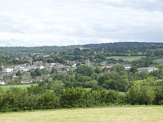
Axminster is a market town and civil parish on the eastern border of the county of Devon in England. It is 28 miles (45 km) from the county town of Exeter. The town is built on a hill overlooking the River Axe which heads towards the English Channel at Axmouth, and is in the East Devon local government district. At the 2001 census, it had a population of 5,626, increasing to 5,761 at the 2011 census. The town contains two electoral wards the total sum of both wards being a population of 7,110. The market is still held every Thursday.

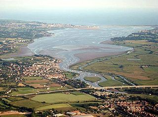
The River Axe is a 22-mile (35 km) long river in the counties of Dorset, Somerset and Devon, in the south-west of England. It rises in Dorset and flows south to Lyme Bay which it enters through the Axe Estuary in Devon. It is a shallow, non-navigable river, although its mouth at Seaton has some boating activity. The name Axe derives from a Common Brittonic word meaning "abounding in fish", and is cognate with pysg, the Welsh word for fish.

The Tamar is a river in south west England, that forms most of the border between Devon and Cornwall. A part of the Tamar Valley is a World Heritage Site due to its historic mining activities.

The River Dart is a river in Devon, England, that rises high on Dartmoor and flows for 75 kilometres (47 mi) to the sea at Dartmouth.

Barnstaple is a river-port town in North Devon, England, at the River Taw's lowest crossing point before the Bristol Channel. From the 14th century, it was licensed to export wool and won great wealth. Later it imported Irish wool, but its harbour silted up and other trades developed such as shipbuilding, foundries and sawmills. A Victorian market building survives, with a high glass and timber roof on iron columns. The parish population was 24,033 at the 2011 census, and that of the built-up area 32,411 in 2018. The town area with nearby settlements such as Bishop's Tawton, Fremington and Landkey, had a 2020 population of 46,619.
The River Exe in England rises at Exe Head, near the village of Simonsbath, on Exmoor in Somerset, 8.4 kilometres (5 mi) from the Bristol Channel coast, but flows more or less directly due south, so that most of its length lies in Devon. It flows for 60 miles (96 km) and reaches the sea at a substantial ria, the Exe Estuary, on the south coast of Devon. Historically, its lowest bridging point was the Old Exe Bridge in Exeter, the largest settlement on the river, but there is now a viaduct for the M5 motorway about 3 kilometres (2 mi) south of the city centre.

Buckfastleigh is a market town and civil parish in Devon, England situated beside the Devon Expressway (A38) at the edge of the Dartmoor National Park. It is part of Teignbridge and, for ecclesiastical purposes, lies within the Totnes Deanery. It is 18 miles east-northeast of Plymouth, 20 miles southwest of Exeter and has a population of 3,661. It is a centre of tourism and is home to Buckfast Abbey, the South Devon Railway, the Buckfastleigh Butterfly Farm and Otter Sanctuary, the Tomb of Squire Richard Cabell and The Valiant Soldier.
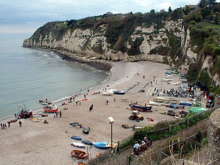
Beer is a village and civil parish in the East Devon district of Devon, England. The village faces Lyme Bay and is a little over 1 mile (1.6 km) west of the town of Seaton. It is situated on the Jurassic Coast World Heritage Site and its picturesque cliffs, including Beer Head, form part of the South West Coast Path.
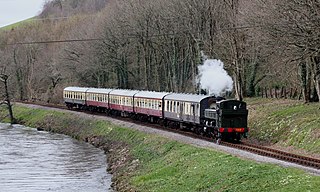
The South Devon Railway (SDR) is a 6.64-mile (10.69 km) heritage railway from Totnes to Buckfastleigh in Devon. Mostly running alongside the River Dart, it was initially known as the Dart Valley Railway. The railway is now operated by the South Devon Railway Trust, a registered charity.
Kinross is a small gold mining town in Mpumalanga, South Africa with four gold mines in the region. Village on the watershed between the Atlantic and Indian Oceans, between Devon and Trichardt, 42 km west of Bethal, 19 km east of Leslie and about 70 km north-north-east of Standerton.

Alverdiscott is a village, civil parish, former manor and former ecclesiastical parish in the Torridge district of Devon, England, centred 5.5 miles (9 km) south-south-west of Barnstaple.

Whimple is a village and civil parish in East Devon in the English county of Devon, approximately 9 miles (14 km) due east of the city of Exeter, and 3 miles (4.8 km) from the nearest small town, Ottery St Mary. It has a population of 1,642, recounted to 1,173 for the village alone in the United Kingdom Census 2011. The electoral ward with the same name had a population of 2,380 at the above census.
Brendon is a village in Devon, England, close to the border with Somerset within the Exmoor National Park. The village is 1.5 miles (2.4 km) southeast of Lynton and 15 miles (24 km) west of Minehead in the East Lyn Valley. It is located just off the A39 and is on two long distance footpaths, the Coleridge Way and the Samaritans Way South West. The Church of St Brendon is 2 mi (3 km) from the village and was built in 1738, possibly with building material brought from another site.

The River Lew can refer to either of two short rivers that lie close to each other in Devon, England.

East Allington is a village and civil parish in the South Hams district of Devon, England, three miles (5 km) south of Halwell and just off the A381 road. It lies about three miles (5 km) from Kingsbridge and about ten miles (16 km) from Totnes. The coast at Slapton Sands is about five miles (8 km) to the south-east. Also in the parish is the hamlet of The Mounts, about one mile (1.6 km) away.

Musbury is a village and civil parish in the East Devon district of Devon, England. It lies approximately 2 miles (3 km) away from Colyton and 2+1⁄2 miles (4 km) away from Axminster, the nearest towns. Musbury is served by the A358 road and lies on the route of the East Devon Way, a 40-mile (64 km) footpath following the Axe Valley. The village is within the East Devon Area of Natural Beauty. It has a post office, primary school, public house, fuel station and church. The parish population at the 2011 census was 543.

Bratton Clovelly is a village, parish and former manor in the west part of Devon, England. It is situated about 8 miles (13 km) south-west of Okehampton immediately north of the A30 road. The manor of Bratton Clovelly was listed in the Domesday Book of 1086. The parish church dedicated to St Mary is 15th-century, with many Norman features. The former village stocks are kept in the belfry. The parish is thought to have been the birthplace of influential 13th-century jurist Henry de Bracton; however, this claim is also made for at least two other places.

Iddesleigh is a village and civil parish in the county of Devon, England. The settlement has ancient origins and is listed in the Domesday Book. The village lies on the B3217 road, roughly central in its parish of around 2,900 acres (1,200 ha), about 8 miles (13 km) north of the town of Okehampton.

Chivelstone is a village and civil parish in Devon, England. The parish contains the villages of East Prawle and South Allington as well as the hamlets of Ford and Lannacombe. The population of the parish taken at the 2011 census was 280.


