
Jammu and Kashmir was a region formerly administered by India as a state from 1954 to 2019, constituting the southern and southeastern portion of the larger Kashmir region, which has been the subject of a dispute between India, Pakistan and China since the mid-20th century. The underlying region of this state were parts of the former princely state of Jammu and Kashmir, whose western districts, now known as Azad Kashmir, and northern territories, now known as Gilgit-Baltistan, are administered by Pakistan. The Aksai Chin region in the east, bordering Tibet, has been under Chinese control since 1962.

The Districts of Pakistan ; are the third-order administrative divisions of Pakistan, below provinces and divisions, but forming the first tier of local government. In total, there are 130 districts in Pakistan, including the Islamabad Capital Territory, 10 districts in Pakistan's dependent territory of Azad Kashmir, and 14 districts in Pakistan's dependent territory of Gilgit Baltistan. Districts are divided into tehsils, which are further divided into union councils.
Rawalpindi District, is a district located in the northernmost part of the Punjab province of Pakistan. Parts of the district form part of the Islamabad Rawalpindi metropolitan area. Rawalpindi city is the district capital.

Abbottabad District is a district of the Pakistani province of Khyber Pakhtunkhwa. It is part of Hazara Division and covers an area of 1,969 km2, with the city of Abbottabad being the principal town. Neighbouring districts are Mansehra to the north, Muzaffarabad to the east, Haripur to the west, and Rawalpindi to the south.

Mansehra District is a district in Hazara Division of Khyber Pakhtunkhwa province in Pakistan. The district and town are named after the Sikh Khalsa Army general Mahan Singh Mirpuri, who founded the city. It is an important and popular tourist destination due to the Lulusar-Dudipatsar National Park and Kaghan Valley area being located in the district and the Karakoram Highway passing through the district. It is main gateway to upper valleys of Kaghan, Naran and also to Gilgit-Baltistan and Azad Kashmir.

Peshawar District is a district in Peshawar Division of Khyber Pakhtunkhwa province in Pakistan. It is located about 160 km west of the Pakistan's capital Islamabad. The district headquarter is Peshawar, which is also the capital of Khyber Paktunkhwa.
Jhang District is a district of Faisalabad Division in the Punjab province, Pakistan. The city of Jhang is the district's capital. In 2009, the tehsil of Chiniot became the separate Chiniot District.

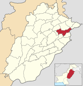
Khushab District is a district in the province of Punjab, Pakistan, with its administrative capital in Jauharabad. The district is named after the historical city of Khushab located within its boundaries. According to the 1998 census, the population was 905,711 with 24.76% living in urban areas. The district consists of four tehsils, Khushab, Noorpur Thal, Quaidabad and Naushera. Khushab is home to the Heavy Water and Natural Uranium Research Reactor, part of the Pakistan's Special Weapons Program.

Chakwal District is in Pothohar Plateau of Punjab, Pakistan. It is located in the north of the Punjab province, Chakwal district is bordered by Khushab to its south, Rawalpindi to its north east, Jhelum to its east, Mianwali to its west and Attock to its north west. The district was created out of parts of Jhelum and Attock in 1985.

Vehari District, , is a district in the Punjab province of Pakistan. The city of Vehari is the capital of district while Burewala is the largest city of the district.

Attock District is a district in Pothohar Plateau of the Punjab Province of Pakistan. Its capital is Attock city.

Multan District, is a district in the Punjab province of Pakistan. According to the 1998 census of Pakistan it had a population of 3,116,851. Its capital is the city of Multan. The district of Multan is spread over an area of 3,721 square kilometres.
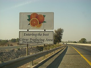
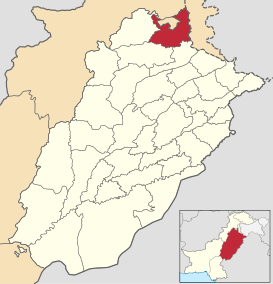
Sargodha District, is a district of Punjab, Pakistan. The capital of the district is Sargodha. It is an agricultural district, wheat, rice, and sugarcane being its main crops. The Sargodha district and region is also famous for citrus fruit including Kinnow, orange and lemon. The district has an area of 5,864 km2.

Khanewal District is a district of the Punjab province of Pakistan. According to the 1998 census of Pakistan, the district had a population of 2,068,490, of which 17.42% were urban. Khanewal is located at 30°18'0N 71°55'0E with an altitude of 128 metres.

Faisalabad District is one of the districts of Punjab province, Pakistan. According to the 1998 census of Pakistan it had a population of 3,029,547 of which almost 42% were in Faisalabad City. It is the third largest city of Pakistan after Karachi and Lahore.

Bhakkar District, is a district in the province of Punjab, Pakistan. The district was created out of parts of Mianwali in 1982, and has the city of Bhakkar as its headquarters. Its area consists of a riverine tract along the Indus, called Kaccha, and most of the district area lies in the desolate plain of the Thal desert.
Narowal District, is a district in the province of Punjab of Pakistan. Narowal city is the capital of the district. During the British rule, Narowal was the town of Raya Khas tehsil of Sialkot District. Narowal District formed in 1991, when the two tehsils of Narowal and Shakargarh were split off from Sialkot District.
Sheikhupura District, is a district located in Lahore Division of Punjab province, Pakistan. Sheikhupura is the headquarters of Sheikhupura district. According to the 1998 census of Pakistan, the district had a population of 3,321,029 of which 25.45% were urban. In 2005 one of its subdivisions was split off to form the new Nankana Sahib District.

The 2017 Census of Pakistan was a detailed enumeration of the Pakistani population which began on 15 March 2017 and ended on 25 May 2017. The census was conducted by the Pakistan Bureau of Statistics for the first time in 21st century, after 19 years. Initial estimates estimated the population at 210–220 million. The provisional results were finally presented to the Council of Common Interests on 25 August 2017, and then approved and released to the public. The results showed a total population of Pakistan at 207,774,520 people. It didn't include the population of Pakistan's dependent territories Azad Kashmir and Gilgit-Baltistan.

Jammu and Kashmir is a region administered by India as a union territory and consists of the southern portion of the larger Kashmir region, which has been the subject of a dispute between India and Pakistan since 1947, and between India and China since 1962. The region of Jammu and Kashmir is separated by the Line of Control from the Pakistani-administered territories of Azad Kashmir and Gilgit-Baltistan in the west and north, respectively. It lies to the north of the Indian states of Himachal Pradesh and Punjab and to the west of Ladakh, which is also subject to the dispute as a part of Kashmir, and administered by India as a union territory.
