Related Research Articles

Laškovce is a village and municipality in Michalovce District in the Kosice Region of eastern Slovakia.
Trhovište is a village and municipality in Michalovce District in the Košice Region of eastern Slovakia.

Taktisches Luftwaffengeschwader 74, formerly known as Jagdgeschwader 74 , is an aviation unit of the German Air Force, based on Neuburg Air Base in Bavaria since 1961. On 1 October 2013, the unit was renamed in the course of adaptations to the new structure of the German Air Force.

Komlódtótfalu is a village in Szabolcs-Szatmár-Bereg county, in the Northern Great Plain region of eastern Hungary.
Ankalagi is a village in Gokak taluk, Belagavi district of Karnataka state in southern India. It is situated about 15 miles south-west of Gokak and about 3 miles away from Suladhal railway station and is located on the bank of Markandeya river. It is a big village consisting of 64 small villages. Earlier, all this area was popularly known as "Kundara Nadu" and known for its freedom fighters - Deshpandes'. Ankalagi is also famous for the temple of Shri Adavi Siddeshwara. Surrounding villages include Akkatangerahal, Lagameshwar, Gujanal, Suladhal, Yaddalagudd, budihal Hudali, Pachapur and many more. A weekly market is held on Friday where all village peoples gather and arrange the market.
Meghrashat is a village in the Amasia Municipality of the Shirak Province of Armenia.
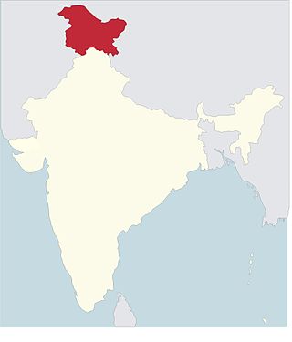
The Roman Catholic Diocese of Jammu–Srinagar is a diocese located in the cities of Jammu and Srinagar in the ecclesiastical province of Delhi in India.
Şilim is a village in the municipality of Kənarmeşə in the Lankaran Rayon of Azerbaijan.
Arsikeri or Arasikere is a hobli and major village/town in the Harapanahalli Taluk of Vijayanagara District in the state of Karnataka, India. It is located in the 15km away from Harapanahalli city in Karnataka, and it was lied in state highway 47.

Bustarviejo is a municipality of the autonomous community of Madrid in central Spain. It belongs to the comarca of Sierra Norte.
The siege of Mangalore was conducted during the Second Anglo-Mysore War by Tipu Sultan and forces of the Kingdom of Mysore against a British East India Company garrison led by Colonel Campbell. The port city of Mangalore on the west coast of India was besieged from 20 May 1783 until the garrison capitulated on 30 January 1784 after being reduced to starvation; of the original garrison of 700 British soldiers and 2000 Indian troops there were only 850 survivors. The siege was one of the last major actions of the war; Mangalore was where the treaty ending the war was signed in March 1784.
Balogi is a village in Belgaum district in the southern state of Karnataka, India.
Hiremele is a village in Belgaum district in the southern state of Karnataka, India.
Metyal is a village in Belgaum district of Karnataka, India.
Navalgatti is a village in Belgaum district of Karnataka, India.
Olamani is a village in Belgaum district of Karnataka, India.

Golemo Selo is a village in the municipality of Vranje, Serbia. According to the 2002 census, the village has a population of 1051 people.
Hale Tegur is a village in Dharwad district of Karnataka, India.
Reshetnikovo is the name of several inhabited localities in Russia.
Bhangali is a village in Phillaur in Jalandhar district of Punjab State, India. It is located 6 kilometres (3.7 mi) from sub district headquarter and 32 kilometres (20 mi) from district headquarter. The village is administrated by Sarpanch an elected representative of the village.
References
30°42′N74°51′E / 30.700°N 74.850°E
| | This article about a location in the Indian state of Punjab is a stub. You can help Wikipedia by expanding it. |