
The Antarctic is a polar region around Earth's South Pole, opposite the Arctic region around the North Pole.
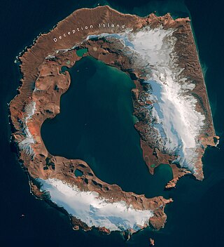
Deception Island is an island in the South Shetland Islands close to the Antarctic Peninsula with a large and usually "safe" natural harbor, which is occasionally troubled by the underlying active volcano. This island is the caldera of an active volcano, which seriously damaged local scientific stations in 1967 and 1969. The island previously held a whaling station. It is now a tourist destination with over 15,000 visitors per year. Two research stations are operated by Argentina and Spain during the summer season. While various countries have asserted sovereignty, it is still administered under the Antarctic Treaty System.

The South Shetland Islands are a group of Antarctic islands with a total area of 3,687 km2 (1,424 sq mi). They lie about 120 kilometres north of the Antarctic Peninsula, and between 430 and 900 km southwest of the nearest point of the South Orkney Islands. By the Antarctic Treaty of 1959, the islands' sovereignty is neither recognized nor disputed by the signatories and they are free for use by any signatory for non-military purposes.

Cockburn Island is an oval island 2.7 kilometres (1.7 mi) long, consisting of a high plateau with steep slopes surmounted on the northwest side by a pyramidal peak 450 m (1,476 ft) high, lying in the north-east entrance to Admiralty Sound, south of the north-east end of the Antarctic Peninsula. It was discovered by a British expedition (1839–43) led by Captain James Clark Ross, who named it for Admiral Sir George Cockburn, then serving as First Naval Lord.

The Aitcho Islands are a group of minor islands on the west side of the north entrance to English Strait separating Greenwich Island and Robert Island in the South Shetland Islands, Antarctica, which are situated between Dee Island to the south and Table Island to the north. The group is separated from Dee Island and Sierra Island to the southwest by Villalón Passage. The area was visited by early 19th century sealers operating from nearby Clothier Harbour. During the austral summer the islands are often visited by Antarctic cruise ships with tourists who land to watch wildlife.

Yankee Harbour is a small inner harbour entered from Shopski Cove between Glacier Bluff and Spit Point, indenting the south-west side of Greenwich Island in the South Shetland Islands, Antarctica. It is 2.35 km (1.46 mi) long in west-south-west to east-north-east direction, and 1.6 km (0.99 mi) wide, and is bounded by Provadiya Hook to the south-west, Parvomay Neck to the north and east, and Kladara Beach to the south.
Bryum dixonii, commonly known as Dixon's threadmoss, is a moss endemic to Scotland. The species occupies montane habitats, and although rare it has a wide distribution including the central and north-west Highlands, and the islands of Skye, Rùm and St Kilda. Originally discovered on Ben Narnain, Argyll, in 1898 by Hugh N. Dixon, it was not seen again until 1964 when found by Ursula Duncan at Juanjorge in Glen Clova in Angus. As of 2000 there was no species action plan for its protection.
Andreaea depressinervis is a species of moss in the family Andreaeaceae that was discovered by Jules Cardot in 1901. It is found on both the South Shetland Islands and the Antarctica.
Andreaea gainii is a species of moss native to western Antarctica and the South Shetland Islands. It grows on exposed rocks and soil.
Andreaea regularis is a species of moss that grows in Antarctica and on the South Shetland Islands.
Didymodon gelidus is a species of mosses that grows in Antarctica and on the South Shetland Islands.

Sphagnum palustre, the prairie sphagnum or blunt-leaved bogmoss, is a species of peat moss from the genus Sphagnum, in the family Sphagnaceae. Like other mosses of this type it can soak up water up to the 30-fold amount of its own dry weight thanks to its elastic spiral fibers. S. palustre is rather frequent and is spread almost all over the world. It mainly grows in wet forests and—compared to other specimens of this genus—rarely grows in moors.

Coppermine Peninsula is the rugged, rocky promontory forming the northwest extremity of Alfatar Peninsula and Robert Island in the South Shetland Islands, Antarctica. It lies between the English Strait to the west and Carlota Cove to the east. It is 1.7 km long, 500 m wide and rising to 105 m.

Calliergon cordifolium is a species of moss in the Calliergonaceae family, commonly known as the calliergon moss or heart-leaved spearmoss. The species is abundant in the right habitat, and grows in marshes and wet woodland, especially woodland of alder (Alnus) or willow (Salix), as well as around streams, ditches and pools. The species grows in tufts among other moss species. Calliergon cordifolium requires a wet environment to grow, and often grows completely submerged in water. It typically prefers lowland, but has been recorded as high as 910 metres (1,000 yd) above sea level in Inverness, Scotland. The species has a circumpolar Boreo-temperate distribution. It is found throughout Europe. It has been recorded in north and central Asia, as well as Turkey and Japan, throughout North America and in New Zealand.

Hennediella heimii, also known as Heim's pottia, is a moss with 2.5 mm brown or yellow-green tufts.

Racomitrium lanuginosum is a widespread species of moss found in montane and arctic tundra, the genus Racomitrium is found across the Northern and Southern hemispheres., however Racomitrium lanuginosum is only found in the Northern hemisphere. It grows as large mats on exposed rock and in boulder scree, particularly on acidic rocks. Its leaves have a characteristically decurrent and toothed hair-point, which gives rise to its regional common names woolly fringemoss, hoary rock-moss and woolly moss.

Metzgeria furcata, the forked veilwort, is a frequent liverwort growing on the bark of a wide range of tree and shrub species and occasionally on rocks. It is a slim, translucent thallose liverwort that forms yellow-green mats of branches about 1mm wide.

Rhizomnium punctatum, also called dotted thyme-moss, is a small species in the genus Rhizomnium.

Saffar Island is the rocky island off the north coast of Elephant Island in the South Shetland Islands, Antarctica extending 290 m in west–east direction and 230 m in south–north direction, with a surface area of 3.64 ha. It is separated from Elephant Island by a passage narrowing to 325 m at points.
Biruni Island is the rocky island off the north coast of Elephant Island in the South Shetland Islands, Antarctica 450 m long in southwest–northeast direction and 150 m wide, with a surface area of 3.59 ha. It is separated from Elephant Island by a passage narrowing to 70 m at points. The island was formed as a result of the retreat of Elephant Island's ice cap at the turn of the 21st century.

