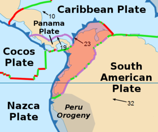
The North Andes Plate or North Andes Block is a small tectonic plate (microplate) located in the northern Andes. It is squeezed between the faster moving South American Plate and the Nazca Plate to the southwest. Due to the subduction of the Coiba and Malpelo plates, this area is very prone to volcanic and seismic activity, with many historical earthquakes.
The Colhuehuapian age is a period of geologic time within the Early Miocene epoch of the Neogene, used more specifically within the SALMA classification in South America. It follows the Deseadan and precedes the Santacrucian age.
The Friasian age is a period of geologic time within the Early Miocene epoch of the Neogene, used more specifically within the SALMA classification of South America. It follows the Santacrucian and precedes the Colloncuran age.
The Chacarilla Formation is an Oxfordian to Early Cretaceous geologic formation of the Tarapacá Basin in northern Chile, close to the border with Bolivia. The marine and fluvial formation preserves several dinosaur trackways and has been declared a Natural Sanctuary in 2004.

The Paja Formation is an Early Cretaceous geologic formation of central Colombia. The formation extends across the northern part of the Altiplano Cundiboyacense, the Western Colombian emerald belt and surrounding areas of the Eastern Ranges of the Colombian Andes. In the subsurface, the formation is found in the Middle Magdalena Valley to the west. The Paja Formation stretches across four departments, from north to south the southernmost Bolívar Department, in Santander, Boyacá and the northern part of Cundinamarca. Well known fossiliferous outcrops of the formation occur near Villa de Leyva, also written as Villa de Leiva, and neighboring Sáchica.
Neoptychites is an extinct ammonoid cephalopod genus from the Turonian stage of the Upper Cretaceous, with a worldwide distribution.

Fagesia is a small, subglobular ammonite belonging to the vascoceratid family of the Acanthocerataceae that lived during the Turonian stage of the Late Cretaceous, 92–88 Ma ago.
Acodus is an extinct genus of conodonts.
Cordylodus is an extinct genus of conodonts in the family of Cordylodontidae.
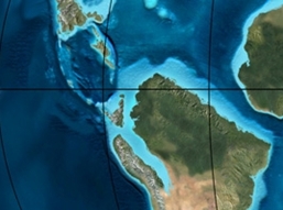
The Chipaque Formation (Spanish: Formación Chipaque, K2cp, Kc) is a geological formation of the Altiplano Cundiboyacense, Eastern Ranges of the Colombian Andes. The formation is also described as Gachetá Formation, named after Gachetá, in the area of the Llanos foothills of the Eastern Ranges. The predominantly organic shale formation dates to the Late Cretaceous period; Cenomanian-Turonian epochs and has a maximum thickness of 1,700 metres (5,600 ft). The formation, rich in TOC, is an important oil and gas generating unit for the giant oilfields Cupiagua and Cusiana of the Eastern Ranges as well as in the Llanos Orientales.

The La Frontera Formation (Spanish: Formación La Frontera, K2F, Ksf) is a geological formation, part of the Villeta Group, of the Altiplano Cundiboyacense and neighbouring areas of the Eastern Ranges of the Colombian Andes. The sequence of limestones and lydites dates to the Late Cretaceous period; Turonian epoch and has a maximum thickness of 206 metres (676 ft).
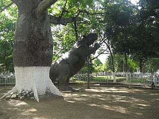
The Honda Group is a geological group of the Upper and Middle Magdalena Basins and the adjacent Central and Eastern Ranges of the Colombian Andes. The group, in older literature also defined as formation, is in its present-day type section in the Tatacoa Desert in the department of Huila subdivided into two main formations; La Victoria and Villavieja.
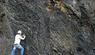
The Macanal Formation or Macanal Shale is a fossiliferous geological formation of the Altiplano Cundiboyacense and Tenza Valley in the Eastern Ranges of the Colombian Andes. The predominantly organic shale formation dates to the Early Cretaceous period; Berriasian to Valanginian epochs and has a maximum thickness of 2,935 metres (9,629 ft). The Macanal Formation contains numerous levels of fossiliferous abundances. Bivalves, ammonites and fossil flora have been found in the formation.
The Irlanda Fault is a dextral strike-slip fault in the department of Cauca in south-central Colombia. A small portion of the fault runs through Huila. The fault has a total length of 54.6 kilometres (33.9 mi) and runs along an average northeast to southwest strike of 023 ± 4 in the Central Ranges of the Colombian Andes. The fault is active and associated with the deadly 1994 Páez River earthquake.

The Loma Gorda Formation is a fossiliferous geological formation of the Upper Magdalena Valley (VSM) and surrounding Central and Eastern Ranges of the Colombian Andes, extending from Cundinamarca in the north to Huila and easternmost Tolima in the south. The uppermost unit of the Güagüaquí Group, a sequence of laminated siltstones and shales, dates to the Late Cretaceous period; Turonian to Coniacian epochs, and has a maximum thickness of 167 metres (548 ft).

The Caballos Formation is a geological formation of the Upper Magdalena Valley (VSM), Caguán-Putumayo Basin, Central and Eastern Ranges of the Colombian Andes. The sandstone and shale formation dates to the Middle Cretaceous period; Aptian to Albian epochs and has a maximum thickness of 411 metres (1,348 ft).
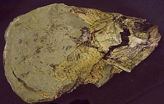
Bachea is an extinct genus of ray-finned fish that lived during the Late Cretaceous in what is now central Colombia, South America. The type species is Bachea huilensis, described in 1997 by María Páramo from the Turonian of Huila, Colombia.

The Chibcha Terrane, named after Chibcha, is the largest of the geological provinces (terranes) of Colombia. The terrane, the oldest explored domains of which date to the Meso- to Neoproterozoic, is situated on the North Andes Plate. The megaregional Romeral Fault System forms the contact of the terrane with the Tahamí Terrane. The contact with the Caribbean and La Guajira Terranes is formed by the regional Bucaramanga-Santa Marta Fault. The northeastern boundary is formed by the regional Oca Fault, bounding the La Guajira Terrane. The terrane is emplaced over the Río Negro-Juruena Province of the Amazonian Craton along the megaregional Eastern Frontal Fault System.
The Venado Formation is a geological formation of the Agua Blanca Group, in the Eastern Ranges of the Colombian Andes, cropping out along the Venado River in northern Huila. The sequence of pyrite containing dark grey micaceous shales interbedded with siltstones and sandstones dates to the Ordovician period; Middle to Late Floian epoch, and has a maximum thickness of 670 metres (2,200 ft) in the type section.


