Related Research Articles

Baramulla district or Varmul is one of the 20 districts in the Indian union territory of Jammu and Kashmir. Baramulla town is the administrative headquarters of this district. The district covered an area of 4,588 km2 (1,771 sq mi) in 2001, but it was reduced to 4,243 km2 (1,638 sq mi) at the time of 2011 census. In 2016, the district administration said that the area was 4,190 km2 (1,620 sq mi). Muslims constitute about 98% of the population among which Shia Muslims form 30-35% and Sunni Muslims form 65-70%.

Baramulla, also known as Varmul in Kashmiri, is a city and a municipality in the Baramulla district in the Indian union territory of Jammu and Kashmir. It is also the administrative headquarters of the Baramulla district, located on the banks of the River Jhelum downstream from Srinagar, the summer capital of Jammu and Kashmir. The town was earlier known as gateway of Kashmir, serving as the major distribution centre for goods arriving in Kashmir valley through the Jhelum valley cart road.

Poonch or Punch is a district in the Jammu Division of Jammu and Kashmir, India. With headquarters in the town of Poonch, it is bounded by the Line of Control on three sides. The 1947-48 war between India and Pakistan divided the earlier district into two parts. One went to Pakistan and the other became part of the then Indian state of Jammu and Kashmir.

Banihal local pronunciation[ banhal ]is a town and a notified area committee, near Ramban town in Ramban district in the Indian union territory of Jammu and Kashmir. It is a rural and hilly area with Kamirwah being one of the most prominent hills. It is located about 35 km (22 mi) away from Qazigund of Anantnag district on NH 44. However, the distance between Banihal and Qazigund is only 18 km by train on the new railway line which is much shorter than the road. The most common language spoken in the region is Kashmiri; Urdu, Hindi, Gujjari, Pahari and English being other familiar languages. Banihal forms the main gateway to the valley of Kashmir.Some famous visiting places in banihal are neel top and mahu valley.
Handwara is a sub-district and a town in Kupwara district of Kashmir. It was known as Uttar Machipora until the division of Baramulla district in the 1980s resulting in the formation of two new districts: Kupwara and Bandipora. It is located on Baramulla-Handwara National Highway NH-701 and is governed by a municipal committee.
Kupwara is a town and a municipal council in Kupwara district in the Indian union territory of Jammu and Kashmir.

Kupwara district is one of the 10 districts located in the Kashmir Valley Division of Indian administered Kashmir. The talri river( originating in lolab valley and flowing from east to west) and Mawar river are two main rivers in the district. Both of them meet Jhelum river in Baramulla district.

Budgam district is a district in the Indian-administered union territory of Jammu and Kashmir. Created in 1979 with its headquarters at Budgam, it is the district with the largest population of Shias in the Kashmir valley.
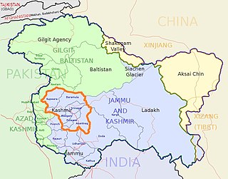
The Kashmir division is a revenue and administrative division of the Indian-administered Jammu and Kashmir. It comprises the Kashmir Valley, bordering the Jammu Division to the south and Ladakh to the east. The Line of Control forms its boundary with the Pakistani-administered territories of Gilgit−Baltistan and Azad Jammu and Kashmir to the north and west and west, respectively.
Pattan is a sub-district, town and a municipal committee in Baramulla district in the Indian union territory of Jammu and Kashmir.

Hathlangoo previously known as Hashmatpora is a village in the Sopore tehsil of Baramulla district in the Indian union territory of Jammu and Kashmir. It is located 8 km (5.0 mi) away from sub-district headquarter Sopore and 22 km (14 mi) away from district headquarters Baramulla. It is one of the largest villages in Zaingair. The Hathlangoo village has Janwara Village in the South, Magraypora in the North, Botingoo in the Northwest, Malmapanpora in the West and Wular Lake in the East.
Gulistan is a village located in the region of North Kashmir with administrative headquarters in Baramulla district in the Indian union territory of Jammu and Kashmir and its sub-district units are pinpointed in Baramulla city. The Gulistan word is derived from which means The Garden of Rose. There are 240 householders residing in Gulistan village which further extends to the total population of 1,634 of which, 825 are males and 809 are females. The literacy rate against the 67.16% of J&K was recorder 59.35% including men and women.
Chaklu is a large village in Baramulla district, Jammu and Kashmir, India. Chaklu village has total population of 3366 of which 1722 are males while 1644 are females.
Fatehgadh is a village located in Narvaw Baramulla tehsil of Baramulla district, Jammu and Kashmir.
Sheeri is a village located in Baramulla district of Jammu and Kashmir, India. The village has two adjoining areas namely "Sheeri Bala" and "Sheeri Payeen".
Budgam, known as Badgom in Kashmiri, is a town in Budgam district in the union territory of Jammu and Kashmir, India. In the 2001 census, it was recorded as having a notified area committee, but by the 2011 census it had a municipal committee.Arath Budgam is the second largest Village of Budgam(Ever Green Public Model School Arath is the popular school in this village).
Kulhama is a village situated in Tangmarg tehsil of Baramulla district in the Indian union territory of Jammu and Kashmir. The village is located 42 kilometres from the district headquarters Baramulla and 7 kilometres from the tehsil headquarters Tangmarg.
Wavoora is a village in Kupwara district of the Indian union territory of Jammu and Kashmir. The town is located 13 km (8.1 mi) from district headquarters Kupwara.
Kalarooch, also known as Kalaroos, is a pass of Kupwara district in the union territory of Jammu and Kashmir, India. It is surrounded by mountains which increases its beauty. The village is located 5 km (3.1 mi) from district headquarters Kupwara.
References
- ↑ "Census of India 2011" (PDF). 26 June 2015. Archived from the original (PDF) on 8 September 2017. Retrieved 26 March 2019.
- ↑ "Dilna Village Population - Baramulla - Baramula, Jammu and Kashmir". census2011.co.in. Retrieved 26 March 2019.
Coordinates: 28°52′N77°40′E / 28.867°N 77.667°E