
Katra is a city and Tehsil in the Reasi district of the Indian union territory of Jammu and Kashmir, situated at the foot of the Trikuta Mountains, where the shrine of Vaishno Devi is located. Katra is located 24 km from the town of Reasi, 42 km (26 mi) from the city of Jammu and around 685 km (426 mi) north of the national capital New Delhi and is the base for pilgrims visiting the Mata Vaishno Devi Temple.
Nowshera is a town and the headquarters of an eponymous tehsil of Rajouri district in the Jammu division of the Indian Union Territory of Jammu and Kashmir. It is governed by a Municipal committee and in rural area of Nowshera consists of 14 panchayats governed by local bodies under the supervision of district administration Rajouri.

Kupwara district is an administrative district of Indian-administered Jammu and Kashmir in the disputed Kashmir region. It is one of the 10 districts located in the Kashmir Valley Division of Indian administered Kashmir. The Pohru River and Mawar river are two main rivers in the district. Both of them meet Jhelum river in Baramulla district.

Bandipore district is an administrative district of Indian-administered Jammu and Kashmir in the disputed Kashmir region. It is one of the 20 districts in the Jammu and Kashmir. Bandipore town is the administrative headquarters of the district. Bandipore is located in the foothills of the snow-clad peaks of Harmukh overlooking the shores of Wular Lake and has produced hundreds of scholars and intellectuals. The district is known for its tourist places such as Wular Vintage Park, Athwatoo and Gurez valley. Before 1947, this town was a big trade and literary centre of Kashmir. This district was carved out from the erstwhile Baramulla district in 2007. The district is bounded by Kupwara district from the north, Baramulla district from west and Kargil district in Ladakh and Ganderbal district from the east. This district occupies an area of 398 km2. The district has a population of 392,232 as per 2011 census.
Qaimoh is a block, a town and a notified area committee in Kulgam District in the union territory of Jammu and Kashmir, India. It is four miles to the west of Anantnag and six miles to the north of Kulgam District. It is 55 km to the south of Srinagar city. Qaimoh is one of the largest blocks in Jammu and Kashmir.
Nathipora is a village in the Bomai block in Sopore tehsil, within the Baramulla District of Jammu and Kashmir, India.

Pethmakhama is a village in Budgam district, in the Indian administrative union territory of Jammu and Kashmir. It falls under the administrative division of tehsil Magam. It is famous for the shrine of Mir Sayyid Ali Hamadani who stayed at various places in and around Kashmir and one example is Pethmakhama where he prayed for around two months. The stone on which he prayed there, has the marks of praying on it miraculously and is preserved at Aasar-i-Shareef Pethmakhama. The shrine also hosts beard hair as one of the holy Relics of Muhammad which is displayed to the devotees every year on the auspicious occasion of Mehraj ul Alam and other festivals. Pethmakhama is irrigated throughout the year by River Sukhnag which is a tributary of Jhelum River and various springs in the village.

Akingam is a village in South Kashmir in the Anantnag district, in the Indian union territory of Jammu and Kashmir. It is at a distance of approximately 14.2 kilometres (8.8 mi) from the Lal Chowk along a route passing through the tourist resorts of Achabal and Kokernag. In revenue records, the village of Akingam is still called Maqan Shiva Bhagwati. The adjacent villages are Mohripura, Hiller, Badasgam, Hardpora and Badoora.
Badran is a village located in district Budgam in the Indian administered union territory of Jammu and Kashmir.
Shankerpora, also known as Shankerpur, is a village in Anantnag district in the Indian-administered union territory of Jammu and Kashmir.

Rajpora, also known as Rajpur, is a Village and a Tehsil in the Pulwama district of the Kashmir Valley of Jammu and Kashmir, India. It is located 43 km (27 mi) away from Srinagar and 299 km (186 mi) away from Jammu. Rajpora is situated at 1,800 metres (5,900 ft) above the mean sea level.
Khadermoh is a village located in Pulwama district in Indian union territory of Jammu and Kashmir. At a distance of 14.6 km, its district headquarters and administrative units are located in Pulwama via Pampore - Kakapora Road and Pulwama-Srinagar Road that connects Khadermoh village to state capital Srinagar which is situated 19.5 km away via NH44 and NH1.
Kalampora, also known as Kalampur or Kalam Pora, is a village in Pulwama district of Jammu and Kashmir, India. This village is situated between Shopian district at a distance of 14 km towards South and Pulwama at a distance of 15 km towards North where its district headquarters are located. It takes 1 hour and 44 minutes to cover the distance of 47 km between Kalampora and state summer capital Srinagar.
Sanger Wani or Sangerwani is a village in Pulwama district of the Indian union territory of Jammu and Kashmir.
Dadina or Dadun is a village of Budgam district situated in Budgam block in Jammu and Kashmir, India. It is only 4 km (2.5 mi) from the district headquarters. It is the most neighbouring vicinity to Budgam.
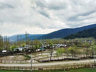
Diver Anderbugh is a village situated in the Lolab Valley, Kupwara, Jammu and Kashmir, India. The village is combination of two places, Diver and Anderbugh. The site is connected to the village of Anderbugh. It is situated 25 kilometres (16 mi) away from district headquarter Kupwara.
Khan Sahib is a town sub-district and a notified area committee in Budgam district in the central Kashmir, union territory of Jammu and Kashmir, India. In 2008, Government Degree College, Khansahib was established in the town to cater to the needs of rural population.
Zainapora is a village in Shopian district in the Indian union territory of Jammu and Kashmir. It is also known as land of springs because of its countless springs. Zainapora is located 19 km (12 mi) from district headquarter Shopian, 4 km (2.5 mi) from Aglar, 17 km from Pulwama, and 63 km (39 mi) from the capital Srinagar.

Chewdara or Chivdora, is a village in the Rathsun block of the Beerwah tehsil in Budgam district of Jammu and Kashmir, India. It is located 21 km (13 mi) towards west of the Budgam district headquarters, 3 km (1.9 mi) from Beerwah and 23 km (14 mi) from the winter capital Srinagar. Chewdara has two panchayats, Chewdara-A and Chewdara-B.
Otligam is a village in tehsil Beerwah of district Budgam of the Jammu and Kashmir. Village plays an important role with respect to education, banking facilities as well as the road connectivity of adjoining villages. Besides this the village has a Primary Health Centre set by Ministry of Ayush.
