
Jammu and Kashmir was a region formerly administered by India as a state from 1952 to 2019, constituting the southern and southeastern portion of the larger Kashmir region, which has been the subject of a dispute between India, Pakistan and China since the mid-20th century. The underlying region of this state were parts of the former princely state of Jammu and Kashmir, whose western districts, now known as Azad Kashmir, and northern territories, now known as Gilgit-Baltistan, are administered by Pakistan. The Aksai Chin region in the east, bordering Tibet, has been under Chinese control since 1962.

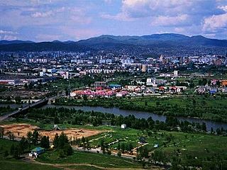
The Srinagar District is one of the 20 districts of the Indian union territory of Jammu and Kashmir. Situated in the centre of the Kashmir Valley, it is the second-most populous district of the union territory after Jammu District as per the 2011 national census, and is home to the summer capital city of Srinagar. Likewise, the city of Srinagar also serves as the Srinagar District's headquarters.

Baramulla district or Varmul is one of the 20 districts in the Indian union territory of Jammu and Kashmir. Baramulla town is the administrative headquarters of this district. The district covered an area of 4,588 km2 (1,771 sq mi) in 2001, but it was reduced to 4,243 km2 (1,638 sq mi) at the time of 2011 census. In 2016, the district administration said that the area was 4,190 km2 (1,620 sq mi). Muslims constitute about 98% of the population among which Shia Muslims form 30-35% and Sunni Muslims form 65-70%.

Doda is a district in the eastern part of Jammu Division in the Indian union territory of Jammu and Kashmir. The district consists of 18 tehsils viz. Thathri, Bhaderwah, Doda, Mohalla, Bhagwa, Assar, Bhalla, Gundna, Marmat, Kahara, Gandoh (Bhalessa), Bhella, Bharat Bagla, Chiralla, Chilly Pingal, Phagsoo and Kastigarh. The climate of the area is not uniform due to wide variations in altitude from place to place. The area, in general, enjoys temperate to sub-tropical type of climate. The climate of the district is almost dry. The rainfall is scanty. The temperature of the district varies from place to place. Ramban and Doda tehsils are fairly warmer while the regions like Dessa Valley tehsil Bhagwah, Gundna, Padder, Marwah and Warwan remain snow bound for five-six months of the year. Summer is generally without rain and precipitation. Almost all the regions experiences snowfall in the winter. The precipitation occurs either in the form of snowfall in higher regions and as rainfall in the lower regions. Monsoons prevail from July to September. Rainfall in the Doda district is heavy during July and September. The average annual rainfall is 926 mm and snowfall of about 135 mm.

Baramulla, also known as Varmul in Kashmiri, is a city and a municipality in the Baramulla district in the Indian union territory of Jammu and Kashmir. It is also the administrative headquarters of the Baramulla district, located on the banks of the River Jhelum downstream from Srinagar, the summer capital of Jammu and Kashmir. The town was earlier known as gateway of Kashmir, serving as the major distribution centre for goods arriving in Kashmir valley through the Jhelum valley cart road.
Anantnag, also called Islamabad, is the administrative headquarters of the Anantnag district in the Indian union territory of Jammu and Kashmir. It is located at a distance of 53 kilometres from the union territory's capital Srinagar. It is the third largest city in Jammu and Kashmir after Srinagar and Jammu with an urban agglomerate population of 159,838 and municipal limit population of 109,433.
Doabgah is a small village in Baramulla district of Jammu and Kashmir, India. The nearest town is Sopore . The name "Doabgah" literally means "a place with two waters". The village has been named so as two prominent rivers of Kashmir meet here, namely Pohru River and Jhelum River. Doabgah was given backward status in 2012 by the government of Jammu and Kashmir. The village is bestowed with two beautiful rivers, Jhelum River on the southern side and Pohru River along the eastern face. The other neighboring villages of Doabgah are Vijabal on the western side and Achabal, Baramulla on the northern front.
Ajas is a newly carved tehsil of Bandipora district, in Jammu and Kashmir, India. Ajas is surrounded by Lar tehsil towards East, Wakura tehsil towards West, Bandipora tehsil towards North and Pattan tehsil towards South. Sopore, Bandipore, Baramula and Srinagar are the nearby Cities to Ajas.
Gulistan is a village located in the region of North Kashmir with administrative headquarters in Baramulla district in the Indian union territory of Jammu and Kashmir and its sub-district units are pinpointed in Baramulla city. The Gulistan word is derived from which means The Garden of Rose. There are 240 householders residing in Gulistan village which further extends to the total population of 1,634 of which, 825 are males and 809 are females. The literacy rate against the 67.16% of J&K was recorder 59.35% including men and women.
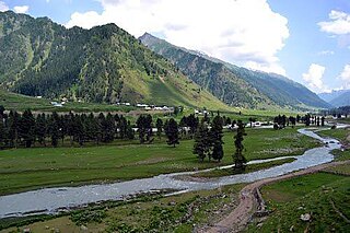
The Warwan Valley is a Himalayan sub-valley and a tehsil in Kishtwar District in the Jammu division in union territory of Jammu and Kashmir in India. The Valley lies 68 kilometres (42 mi) northeast of Kishtwar and 150 kilometres (93 mi) from Srinagar, the summer capital of Jammu and Kashmir.
Chaklu is a large village in Baramulla district, Jammu and Kashmir, India. Chaklu village has total population of 3366 of which 1722 are males while 1644 are females.
Dilna is a village located in Baramulla town of Baramulla district, Jammu and Kashmir with total population of 7599 of which 3835 are males while 3764 are females as per Census 2011.
Fatehgadh is a village located in Narvaw Baramulla tehsil of Baramulla district, Jammu and Kashmir.

Jammu and Kashmir is a region administered by India as a union territory and consists of the southern portion of the larger Kashmir region, which has been the subject of a dispute between India and Pakistan since 1947, and between India and China since 1962. The Line of Control separates Jammu and Kashmir from the Pakistani-administered territories of Azad Kashmir and Gilgit-Baltistan in the west and north. It lies to the north of the Indian states of Himachal Pradesh and Punjab and to the west of Ladakh which is administered by India as a union territory.
Lolipora, also known as Lolipur, is a village and a Panchayat Halqa in Pattan tehsil of Baramulla district in the Indian union territory of Jammu and Kashmir. It is located 23 km (14 mi) towards east of district headquarters, Baramulla and 32 km (20 mi) from the summer capital of Jammu and Kashmir, Srinagar. Sopore, Baramulla, Bandipora and Srinagar are the nearby cities to Lolipora.
Nambla is a census village in Baramula district, Jammu & Kashmir, India.
Khaigam is a census village and Gram Panchayat in Pulwama district, Jammu & Kashmir, India.
Seer Jagir is a census village in the Sopore tehsil of Baramulla district, Jammu & Kashmir, India. As per the 2011 Census of India, Seer Jagir has a total population of 7,997 people including 4,085 males and 3,912 with a literacy rate of 56.81%.
Tarazuea is a census village in the Sopore tehsil of Baramulla district, Jammu & Kashmir, India. As per the 2011 Census of India, Tarazuea has a total population of 6,910 people including 3,504 males and 3,406 with a literacy rate of 53.01%.
Haigam is a census village in Baramulla district, Jammu & Kashmir, India. As per the 2011 Census of India, Haigam has a total population of 6,212 people including 3,148 males and 3,064 with a literacy rate of 60.61%.

