
In meteorology, diurnal temperature variation is the variation between a high air temperature and a low temperature that occurs during the same day.
In meteorology, diurnal temperature variation is the variation between a high air temperature and a low temperature that occurs during the same day.
Temperature lag, also known as thermal inertia, is an important factor in diurnal temperature variation. Peak daily temperature generally occurs after noon, as air keeps absorbing net heat for a period of time from morning through noon and some time thereafter. Similarly, minimum daily temperature generally occurs substantially after midnight, indeed occurring during early morning in the hour around dawn, since heat is lost all night long. The analogous annual phenomenon is seasonal lag.
As solar energy strikes the Earth's surface each morning, a shallow 1–3-centimetre (0.39–1.18 in) layer of air directly above the ground is heated by conduction. Heat exchange between this shallow layer of warm air and the cooler air above is very inefficient. On a warm summer's day, for example, air temperatures may vary by 16.5 °C (30 °F) from just above the ground to chest height. Incoming solar radiation exceeds outgoing heat energy for many hours after noon and equilibrium is usually reached from 3–5 p.m., but this may be affected by a variety of factors such as large bodies of water, soil type and cover, wind, cloud cover/water vapor, and moisture on the ground. [1]
The examples and perspective in this section may not represent a worldwide view of the subject.(February 2020) |
Diurnal temperature variations are greatest very near Earth's surface. The Tibetan and Andean Plateaus present one of the largest differences in daily temperature on the planet, as does the Western US and the western portion of southern Africa.
High desert regions typically have the greatest diurnal-temperature variations, while low-lying humid areas near the shores (tropical, oceanic, and arctic) typically have the least. Large cities (urban heat islands) also tend to have a lowed diurnal temperature variation than surrounding areas. This explains why an area like the Pinnacles National Park can have high temperatures of 38 °C (100 °F) during a summer day, and then have lows of 5–10 °C (41–50 °F). At the same time, Washington D.C., which is much more humid, has temperature variations of only 8 °C (14 °F); [1] [ dead link ] urban Hong Kong has a diurnal temperature range of little more than 4 °C (7.2 °F).
While the National Park Service claimed that the world single-day record is a variation of 102 °F (56.7 °C) (from 46 °F or 7.8 °C to −56 °F or −48.9 °C) in Browning, Montana in 1916, [2] the Montana Department of Environmental Quality claimed that Loma, Montana also had a variation of 102 °F (56.7 °C) (from −54 °F or −47.8 °C to 48 °F or 8.9 °C) in 1972. [3] Both these extreme daily temperature changes were the result of sharp air-mass changes within a single day. The 1916 event was an extreme temperature drop, resulting from frigid Arctic air from Canada invading northern Montana, displacing a much warmer air mass. The 1972 event was a chinook event, where air from the Pacific Ocean overtopped mountain ranges to the west, and dramatically warmed in its descent into Montana, displacing frigid Arctic air and causing a drastic temperature rise.
In the absence of such extreme air-mass changes, diurnal temperature variations typically range from 10 °F (5.6 °C) or smaller in humid, tropical areas, up to 40 to 50 °F (22.2 to 27.8 °C) in higher-elevation, arid to semi-arid areas, such as parts of the U.S. Western states' Intermountain Plateau areas, for example Elko, Nevada, Ashton, Idaho and Burns, Oregon. The higher the humidity is, the lower the diurnal temperature variation is.
In Europe, due to its more northern latitude and close proximity to large warm water bodies (such as the Mediterranean), differences in daily temperature are not as pronounced as in other continents. However, places in Southern Europe significantly far from the Mediterranean tend to have high differences in daily temperatures, some around 14 °C (25 °F). These include Southwestern Iberia (e.g. Alvega or Badajoz) or the high-altitude plateaus of Turkey (if considered part of Europe) (e.g. Kayseri).
In Australia, significant diurnal temperature variations generally occur in the Red Centre around Alice Springs and Uluru.
Diurnal temperature variation is of particular importance in viticulture. Wine regions situated in areas of high altitude experience the most dramatic swing in temperature variation during the course of a day. In grapes, this variation has the effect of producing high acid and high sugar content as the grapes' exposure to sunlight increases the ripening qualities while the sudden drop in temperature at night preserves the balance of natural acids in the grape. [4]

A Mediterranean climate, also called a dry summer climate, described by Köppen as Cs, is a temperate climate type that occurs in the lower mid-latitudes. Such climates typically have dry summers and wet winters, with summer conditions being hot and winter conditions typically being mild. These weather conditions are typically experienced in the majority of Mediterranean-climate regions and countries, but remain highly dependent on proximity to the ocean, altitude and geographical location.

Thermoregulation is the ability of an organism to keep its body temperature within certain boundaries, even when the surrounding temperature is very different. A thermoconforming organism, by contrast, simply adopts the surrounding temperature as its own body temperature, thus avoiding the need for internal thermoregulation. The internal thermoregulation process is one aspect of homeostasis: a state of dynamic stability in an organism's internal conditions, maintained far from thermal equilibrium with its environment. If the body is unable to maintain a normal temperature and it increases significantly above normal, a condition known as hyperthermia occurs. Humans may also experience lethal hyperthermia when the wet bulb temperature is sustained above 35 °C (95 °F) for six hours.

In meteorology, a low-pressure area, low area or low is a region where the atmospheric pressure is lower than that of surrounding locations. Low-pressure areas are commonly associated with inclement weather, while high-pressure areas are associated with lighter winds and clear skies. Winds circle anti-clockwise around lows in the northern hemisphere, and clockwise in the southern hemisphere, due to opposing Coriolis forces. Low-pressure systems form under areas of wind divergence that occur in the upper levels of the atmosphere (aloft). The formation process of a low-pressure area is known as cyclogenesis. In meteorology, atmospheric divergence aloft occurs in two kinds of places:

An oceanic climate, also known as a marine climate or maritime climate, is the temperate climate sub-type in Köppen classification represented as Cfb, typical of west coasts in higher middle latitudes of continents, generally featuring cool to warm summers and cool to mild winters, with a relatively narrow annual temperature range and few extremes of temperature. Oceanic climates can be found in both hemispheres generally between 40 and 60 degrees latitude, with subpolar versions extending to 70 degrees latitude in some coastal areas. Other varieties of climates usually classified together with these include subtropical highland climates, represented as Cwb or Cfb, and subpolar oceanic or cold subtropical highland climates, represented as Cfc or Cwc. Subtropical highland climates occur in some mountainous parts of the subtropics or tropics, some of which have monsoon influence, while their cold variants and subpolar oceanic climates occur near polar or tundra regions.
Seasonal lag is the phenomenon whereby the date of maximum average air temperature at a geographical location on a planet is delayed until some time after the date of maximum daylight. This also applies to the minimum temperature being delayed until some time after the date of minimum insolation. Cultural seasons are often aligned with annual temperature cycles, especially in the agrarian context. Peak agricultural growth often depends on both insolation levels and soil/air temperature. Rainfall patterns are also tied to temperature cycles, with warmer air able to hold more water vapor than cold air.

The climate of India consists of a wide range of weather conditions across a vast geographic scale and varied topography. Based on the Köppen system, India encompasses a diverse array of climatic subtypes. These range from arid and semi-arid regions in the west to highland, sub-arctic, tundra, and ice cap climates in the northern Himalayan regions, varying with elevation. The northern lowlands experience subtropical conditions, with some areas at higher altitudes, like Srinagar, touching continental climates. In contrast, much of the south and the east exhibit tropical climate conditions, which support lush rainforests in these territories. Many regions have starkly different microclimates, making it one of the most climatically diverse countries in the world. The country's meteorological department follows the international standard of four seasons with some local adjustments: winter, summer, monsoon or rainy season, and a post-monsoon period.

A pressure system is a peak or lull in the sea level pressure distribution. The surface pressure at sea level varies minimally, with the lowest value measured 87 kilopascals (26 inHg) and the highest recorded 108.57 kilopascals (32.06 inHg). High- and low-pressure systems evolve due to interactions of temperature differentials in the atmosphere, temperature differences between the atmosphere and water within oceans and lakes, the influence of upper-level disturbances, as well as the amount of solar heating or radiationized cooling an area receives. Pressure systems cause weather to be experienced locally. Low-pressure systems are associated with clouds and precipitation that minimize temperature changes throughout the day, whereas high-pressure systems normally associate with dry weather and mostly clear skies with larger diurnal temperature changes due to greater radiation at night and greater sunshine during the day. Pressure systems are analyzed by those in the field of meteorology within surface weather maps.

Louisville is a city in Jefferson County, in the U.S. state of Kentucky. It is located at the Falls of the Ohio River.

Jervis Bay Village is a village in the Jervis Bay Territory, Australia. HMAS Creswell Royal Australian Navy base is located in the village. Apart from the navy base there is an Aboriginal community in the village. It is the largest settlement and de facto capital in the Jervis Bay Territory, with 189 inhabitants.

The climate of Sydney, Australia is humid subtropical, shifting from mild and cool in winter to warm and occasionally hot in the summer, with no extreme seasonal differences since the weather has some maritime influence. Though more contrasting temperatures are recorded in the inland western suburbs, as Sydney CBD is more affected by the oceanic climate drivers than the hinterland.
Oklahoma City lies in a temperate humid subtropical climate, with frequent variations in weather daily and seasonally, except during the consistently hot and humid summer months. Consistent winds, usually from the south or south-southeast during the summer, help temper the hotter weather. Consistent northerly winds during the winter can intensify cold periods. The normal annual mean temperature is 61.4 °F (16.3 °C); the coolest year was 1895 with a mean of 57.9 °F (14.4 °C), while the warmest 2012 at 64.1 °F (17.8 °C). Precipitation averages 36.52 inches (928 mm) annually, falling on an average 84 days, with the warmer months receiving more; annual precipitation has historically ranged from 15.74 in (400 mm) in 1901 to 56.95 in (1,447 mm) in 2007. The sun shines about 69% of the time, with monthly percent possible sunshine ranging from 60% in December to 80% in July.

Minnesota has a humid continental climate, with hot summers and cold winters. Minnesota's location in the Upper Midwest allows it to experience some of the widest variety of weather in the United States, with each of the four seasons having its own distinct characteristics. The area near Lake Superior in the Minnesota Arrowhead region experiences weather unique from the rest of the state. The moderating effect of Lake Superior keeps the surrounding area relatively cooler in the summer and warmer in the winter, giving that region a smaller yearly temperature variation. On the Köppen climate classification, much of the southern third of Minnesota—roughly from the Twin Cities region southward—falls in the hot summer zone (Dfa), and the northern two-thirds of Minnesota falls in the warm summer zone (Dfb).

Australia's climate is governed mostly by its size and by the hot, sinking air of the subtropical high pressure belt. This moves north-west and north-east with the seasons. The climate is variable, with frequent droughts lasting several seasons, thought to be caused in part by the El Niño-Southern Oscillation. Australia has a wide variety of climates due to its large geographical size. The largest part of Australia is desert or semi-arid. Only the south-east and south-west corners have a temperate climate and moderately fertile soil. The northern part of the country has a tropical climate, varying between grasslands and desert. Australia holds many heat-related records: the continent has the hottest extended region year-round, the areas with the hottest summer climate, and the highest sunshine duration.

North Dakota's climate is typical of a continental climate with cold winters and warm-hot summers. The state's location in the Upper Midwest allows it to experience some of the widest variety of weather in the United States, and each of the four seasons has its own distinct characteristics. The eastern half of the state has a humid continental climate with warm to hot, somewhat humid summers and cold, windy winters, while the western half has a semi-arid climate with less precipitation and less humidity but similar temperature profiles. The areas east of the Missouri River get slightly colder winters, while those west of the stream get higher summer daytime temperatures. In general, the diurnal temperature difference is prone to be more significant in the west due to higher elevation and less humidity.

The climate of the United States varies due to changes in latitude, and a range of geographic features, including mountains and deserts. Generally, on the mainland, the climate of the U.S. becomes warmer the farther south one travels, and drier the farther west, until one reaches the West Coast.

The climate of New York (state) is generally humid continental, while the extreme southeastern portion of the state lies in the warmer humid subtropical climate zone. Winter temperatures average below freezing during January and February in much of the state of New York, but several degrees above freezing along the Atlantic coastline, including New York City.
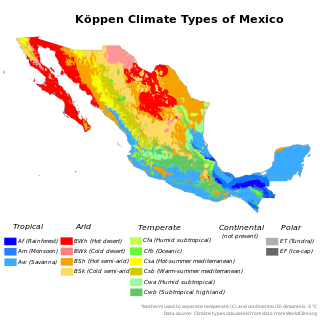
The climate of Mexico is very diverse. The Tropic of Cancer effectively divides the country into temperate and tropical zones. Land that is north of the twenty-fourth parallel experiences lower temperatures during the winter months. South of the twenty-fourth parallel, temperatures are fairly consistent all year round and vary solely as a function of elevation. The north of the country usually receives less precipitation than the south.

A humid subtropical climate is a temperate climate type characterized by long and hot summers, and cool to mild winters. These climates normally lie on the southeast side of all continents, generally between latitudes 25° and 40° and are located poleward from adjacent tropical climates, and equatorward from either humid continental or oceanic climates. It is also known as warm temperate climate in some climate classifications.

Loomis is a census-designated place (CDP) in Okanogan County, Washington, United States. The population was 159 at the 2010 census. Its area is 0.85 square miles (2.2 km2), which is all land and no water.

In late January 2019, a severe cold wave caused by a weakened jet stream around the Arctic polar vortex hit the Midwestern United States and Eastern Canada, killing at least 22 people. It came after a winter storm brought up to 13 inches (33 cm) of snow in some regions from January 27–29, and brought the coldest temperatures in over 20 years to most locations in the affected region, including some all-time record lows. In early February, a concentration of Arctic air colloquially referred to as the "polar vortex" moved west, and became locked over Western Canada and the Western United States. As a result, February 2019 was among the coldest and snowiest on record in these regions. In early March, the cold once again shifted east, breaking records in many areas. In mid-March, the cold wave finally retreated, but combined with above-average temperatures, precipitation, and a deep snowpack, widespread flooding ensued in the Central US.