Baja California, officially Estado Libre y Soberano de Baja California, is a state in Mexico. It is the northernmost and westernmost of the 32 federal entities of Mexico. Before becoming a state in 1952, the area was known as the North Territory of Baja California. It has an area of 70,113 km2 (27,071 sq mi) and comprises the northern half of the Baja California peninsula, north of the 28th parallel, plus oceanic Guadalupe Island. The mainland portion of the state is bordered on the west by the Pacific Ocean; on the east by Sonora, the U.S. state of Arizona, and the Gulf of California; on the north by the U.S. state of California; and on the south by Baja California Sur.

Baja California Sur, officially Estado Libre y Soberano de Baja California Sur, is the least populated state and the last state to be admitted to Mexico, in 1974. It is also the ninth-largest Mexican state in terms of area.
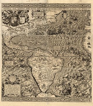
Multiple theories regarding the origin of the name California, as well as the root language of the term, have been proposed, but most historians believe the name likely originated from a 16th-century novel, Las sergas de Esplandián. The novel, popular at the time of the Spanish exploration of Mexico and the Baja California Peninsula, describes a fictional island named California, ruled by a queen named Calafia, east of the Indies. The author of the novel, Garci Rodríguez de Montalvo, also known as Ordóñez de Montalvo, is thought to have derived the term California from the Arabic Khalif and/or Khalifa, but he may also have been influenced by the term "Califerne" in the Song of Roland, an 11th-century epic poem written in Old French.

The 1999 Pacific hurricane season was one of the least active Pacific hurricane seasons on record. The season officially began on May 15 in the Eastern Pacific, and on June 1 in the Central Pacific; in both basins, it ended on November 30. These dates conventionally delimit the period during which most tropical cyclones form in the northeastern Pacific Ocean. The first tropical cyclone of the season, Hurricane Adrian, developed on June 18, while the final storm of the season, Tropical Storm Irwin, dissipated on October 11. No storms developed in the Central Pacific during the season. However, two storms from the Eastern Pacific, Dora and Eugene, entered the basin, with the former entering as a hurricane and becoming the second farthest travelling Pacific hurricane on record.

Juniperus californica, the California juniper, is a species of juniper native to southwestern North America.
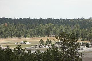
The Sierra Juárez and San Pedro Mártir pine–oak forests is a Nearctic temperate coniferous forests ecoregion that covers the higher elevations of the Sierra Juárez and Sierra San Pedro Mártir ranges of the Peninsular Ranges, of the northern Baja California Peninsula of Mexico. The pine–oak forests extend throughout the central portion of the Mexican state of Baja California and terminate near the border with the U.S. state of California.

Monardella is a genus of approximately 40 species of annual and perennial plants native to western North America from British Columbia to northwestern Mexico. They are grown for their highly aromatic foliage, which in some species is used for herbal teas. The two-lipped, tubular flowers are formed in terminal clusters and are most usually red, pink, or purple.
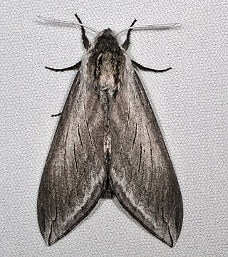
Sphinx perelegans, commonly known as the elegant sphinx, is a species of hawkmoth described by Henry Edwards in 1874. It is a large gray moth native to western North America.

Doidae is a small family of Lepidoptera with an exclusively New World distribution, with species occurring in Central America, the south-western United States, and northern South America.

The peninsula leaf-toed gecko is a medium-sized gecko. It is found in southern California (USA) and Baja California (Mexico), including many islands in Gulf of California as well as Islas Magdalena and Santa Margarita off the west coast of Baja California.

Fouquieria is a genus of 11 species of desert flowering plants, the sole genus in the family Fouquieriaceae. The genus is native to North America and includes the ocotillo and the Boojum tree or cirio. They have semi succulent stems with thinner spikes projecting from them, with leaves on the bases spikes. They are unrelated to cacti and do not look much like them; their stems are proportionately thinner than cactus stems and their leaves are larger.

Doa is a genus of moths of the Doidae family.
Doa ampla is a moth of the family Doidae. It is found from western Texas and Colorado to Arizona, south into Mexico.
Doa raspa is a moth of the Doidae family. It is found in Central America, including Belize.

The California coastal sage and chaparral is a Mediterranean forests, woodlands, and scrub ecoregion, defined by the World Wildlife Fund, located in southwestern California and northwestern Baja California (Mexico). It is part of the larger California chaparral and woodlands ecoregion. The ecoregion corresponds to the USDA Southern California ecoregion section 261B, and to the EPA Southern California/Northern Baja Coast ecoregion 8.

The 2011 Pacific hurricane season consisted of the events that occurred in the annual cycle of tropical cyclone formation over the Pacific Ocean north of the equator and east of the International Date Line. The official bounds of each Pacific hurricane season are dates that conventionally delineate the period each year during which tropical cyclones tend to form in the basin according to the National Hurricane Center (NHC), beginning on May 15 in the Eastern Pacific proper and June 1 in the Central Pacific, and ending on November 30 in both areas. However, tropical cyclogenesis is possible at any time of year. The season generated eleven tropical storms, which is below the 1991–2020 average of fifteen. However, all but one became hurricanes and six further strengthened into major hurricanes, eclipsing the 1991–2020 averages of eight hurricanes and four major hurricanes. There were also two tropical depressions that remained below tropical storm status. The first system, Hurricane Adrian, formed on June 7; the final, Hurricane Kenneth, was the latest in a calendar year to exist east of 140°W since 1983, dissipating on November 25.

Hurricane Dora was the strongest tropical cyclone in the northeastern Pacific in 2011 that brought minor impacts to Mexico and the US in July of that year. The fourth named storm, fourth hurricane, and second major hurricane of the year, Dora developed from a tropical wave south of Honduras on July 18. Moving northwestward in favorable conditions, the system quickly intensified to tropical storm status and attained hurricane intensity the next day. Rapid intensification ensued shortly thereafter, bringing the storm to its peak intensity on July 21 as a Category 4 hurricane, with a minimum barometric pressure of 929 mbar and maximum sustained winds of 155 mph (250 km/h). However, the storm's path into an area with cool sea surface temperatures and wind shear caused Dora to quickly deteriorate and weaken. By July 24, Dora had degenerated into a remnant low-pressure area west of the Baja California Peninsula.

Lophocereus schottii, the senita cactus, is a species of cactus from southern Arizona and north-western Mexico, particularly Baja California and Sonora. Ultramafic soils facilitate the endemism of plant species and are often associated with their distribution.

The 2017 Pacific hurricane season was an event in the annual cycle of tropical cyclone formation, in which tropical cyclones form in the eastern Pacific Ocean. The season officially started on May 15 in the eastern Pacific—east of 140°W—and on June 1 in the central Pacific—between the International Date Line and 140°W—and ended on November 30. These dates typically cover the period of each year when most tropical cyclones form in the eastern Pacific basin. However, storm formation is possible at any time of the year, as illustrated in 2017 by the formation of the season's first named storm, Tropical Storm Adrian, on May 10. At the time, this was the earliest formation of a tropical storm on record in the basin.
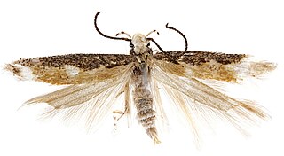
Neopalpa donaldtrumpi is a moth species of the genus Neopalpa occurring in Southern California and Northern Mexico. It was described in 2017 by Iranian-Canadian scientist Vazrick Nazari. Known for its yellowish-white head scales being reminiscent of Donald Trump's hair, the moth was given its name because Nazari stated that he wanted "to bring wider public attention to the need to continue protecting fragile habitats in the US that still contain many undescribed species."
