Bulkley Junction Provincial Park is a provincial park in British Columbia, Canada, located on the west side of the Skeena River opposite Hazelton.

Wakapuaka Cemetery is a cemetery located in Brooklands, Nelson, New Zealand. "Wakapuaka" is a Māori-language word meaning "heaps of aka leaves".
Maungatapu is a mountain in New Zealand included in both the Nelson, New Zealand and Marlborough Regions. It lies in the Bryant Range. The mountain is 1014 meters high. Maungatapu is a Māori-language word meaning "sacred mountain". The mountain was the location of the infamous Maungatapu murders.

Cek is a village in the Quba Rayon of Azerbaijan. The village forms part of the municipality of Əlik. They live, primarily, in the region around Mount Shahdag in Quba Rayon in northeastern Azerbaidzhan.

The Maitai / Mahitahi River is an awa (river) of the northwest of New Zealand's South Island. It flows westwards through hill country west of the Bryant Range before passing through the city of Nelson, reaching Tasman Bay at Nelson Haven. Major tributaries of the Maitai River include The Brook, Te Wairepo / York Stream and Sharland Creek.

The Ertatsminda Cathedral of Eustathius of Mtskheta is a medieval Georgian Orthodox cathedral in Kaspi District, the Shida Kartli region, Georgia. It is situated in the centre of the village Ertatsminda.
The Brook is one of the suburbs of Nelson, New Zealand. It lies to the south of Nelson and is the location of the Brook Waimarama Sanctuary, a conservation project at the head of the Brook Valley.
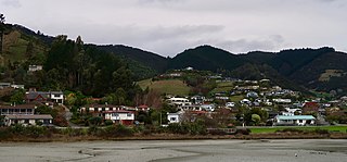
Todds Valley is a small township to the north of Nelson, New Zealand. It lies to the southeast of State Highway 6, immediately to the north of Marybank, New Zealand at the northern tip of Nelson Haven.
Toi Toi is an inner suburb of Nelson, New Zealand. It lies to the southwest of Nelson city centre, inland from Britannia Heights and Washington Valley. Toi Toi is also known as Victory Village.
Washington Valley is a major inner suburb of Nelson, New Zealand. It lies to the west of Nelson city centre between Stepneyville and Beachville.
Port Nelson, as its name suggests, is the main port area of Nelson, New Zealand. It lies to the northwest of Nelson city centre, to the north of Washington Valley, at the southern end of Nelson Haven. The harbour entrance lies at the southwestern end of Boulder Bank, immediately to the west of Port Nelson.
Beachville is an inner suburb of Nelson, New Zealand. It lies at the western edge of Nelson city centre, to the southeast of Port Nelson. Beachville is a village in Ontario, Canada and the location of the first recorded baseball game in 1838.
Maitai is an inner suburb of Nelson, New Zealand. It lies at the western edge of Nelson city centre, immediately to the south of The Wood, on the northern bank of the Maitai River. A monument representing the location of the geographic centre of New Zealand is located in Maitai.
Tasman Heights is one of the suburbs of Nelson, New Zealand. It lies to the southeast of Nelson city centre, between Wakatu and Moana.
Saxton is a suburb at the southern end of Stoke, New Zealand, to the northwest of Richmond, New Zealand. Its principal feature is the Saxton Field sports complex, which includes Saxton Oval, Nelson's main cricket ground.
The Whangamoa Saddle is a pass traversed by New Zealand State Highway 6 on its route between Blenheim and Nelson, immediately to the east of Hira. One of the two passes on the route, the Whangamoa Saddle lies between the valleys of the Whangamoa and Wakapuaka Rivers south of Delaware Bay. The elevation of the pass is 466 metres (1,529 ft) above sea level. The pass marks part of the boundary between Nelson and Marlborough District.
Nelson South is an inner suburb of Nelson, New Zealand. It lies to the southwest of Nelson city centre, between it and Bishopdale, close to the foot of The Grampians. The main inland route to Stoke, New Zealand, Waimea Road, is Nelson South's main road. Notable features of Nelson South include Nelson Public Hospital and Nelson College.
Tahunanui Beach is the main beach in the city of Nelson, New Zealand. It lies on the shore of Tasman Bay on the northern edge of a peninsula which stretches west from the suburb of Tahunanui. The beach is notable for its long shallow slope, and for this reason is extremely popular with local swimmers, as the water is generally calm and warmed by the sun.
Nelson Central is a suburb of Nelson, New Zealand.
Hanby Park is a suburb of Nelson, New Zealand.