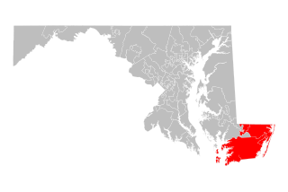
Wicomico County is located in the southeastern part of the U.S. state of Maryland, on the Delmarva Peninsula. As of the 2010 census, the population was 98,733. The county seat is Salisbury. The county was named for the Wicomico River, which in turn derives from Algonquian language words wicko mekee, meaning "a place where houses are built," apparently referring to a Native American town on the banks.

Worcester County is the easternmost county of the U.S. state of Maryland. As of the 2020 census, the population was 52,460. Its county seat is Snow Hill. It is the only county of Maryland that borders the Atlantic Ocean, and the only county bordering both Delaware and Virginia. The county was named for Mary Arundell, the wife of Sir John Somerset, a son of Henry Somerset, 1st Marquess of Worcester. She was sister to Anne Arundell, wife of Cecil Calvert, 2nd Baron Baltimore, the first Proprietor and Proprietary Governor of the Province of Maryland.

Salisbury is a city in and the county seat of Wicomico County, Maryland, United States, and the largest city in the state's Eastern Shore region. The population was 33,050 at the 2020 census. Salisbury is the principal city of the Salisbury, Maryland-Delaware Metropolitan Statistical Area. The city is the commercial hub of the Delmarva Peninsula, which was long devoted to agriculture and had a southern culture. It calls itself "The Comfortable Side of Coastal".

The Eastern Shore of Maryland is a part of the U.S. state of Maryland that lies mostly on the east side of the Chesapeake Bay. Nine counties are normally included in the region. The Eastern Shore is part of the larger Delmarva Peninsula that Maryland shares with Delaware and Virginia.

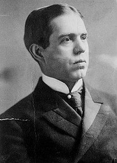
William Purnell Jackson was a Republican member of the United States Senate, representing the State of Maryland from 1912 to 1914. His father, William Humphreys Jackson, was a U.S. Congressman from Maryland.

The Diocese of Wilmington is a Latin Church ecclesiastical territory or diocese of the Catholic Church in the eastern United States and comprises the entire state of Delaware and the Eastern Shore of Maryland. The Diocese of Wilmington is one of four Catholic dioceses in the United States to have territory in more than one federal entity; the Diocese of Gallup and the Diocese of Norwich each span two states while the Archdiocese of Washington spans Washington, D.C. and five counties of Maryland.

The election to choose county executives in Maryland occurred on Tuesday, November 7, 2006. The U.S. House election, 2006, U.S. Senate election, 2006, Maryland gubernatorial election, 2006, 2006 Maryland Senate election and 2006 Maryland House of Delegates election took place on the same day. Seven charter counties elected a county executive: Anne Arundel County, Baltimore County, Harford County, Howard County, Montgomery County, Prince George's County, and Wicomico County. This race coincided with the election for Maryland County Offices Election, 2006.

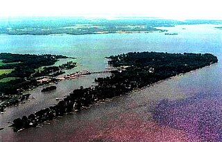
The Wicomico River is a 13.0-mile-long (20.9 km) tributary of the lower tidal portion of the Potomac River located in the U.S. state of Maryland south of Washington, DC. The river empties into the Potomac at Cobb Island and St. Margaret's Island. Its watershed area is 77 square miles (200 km2), with 2% impervious surface in 1994 in Charles, St. Mary's, and southern Prince George's counties. The lower section of the river forms part of the boundary between Charles and St. Mary's counties. The Wicomico River was designated as a Scenic River under the Maryland Scenic River Act in 1968; Scenic River Commissions oversee it in both Charles and St. Mary's counties.
Maryland's 5th congressional district comprises all of Charles, St. Mary's, and Calvert counties, as well as portions of Prince George's and Anne Arundel counties. The district is currently represented by Democrat Steny Hoyer, the current House Majority Leader.

Wicomico High School is a high school located in Salisbury, Wicomico County, Maryland, United States. It is one of four public high schools in Wicomico County along with James M. Bennett High School, Mardela Middle and High School and Parkside High School. Wicomico High School currently enrolls grades 9 through 12. Its mascot is the Indian and its colors are blue and gold.
Don B. Hughes in Salisbury in Wicomico County, Maryland, United States, was a member of the Maryland House of Delegates for District 37A, which covers portions of Dorchester and Wicomico Counties

Parkside High School is a four-year public high school in Salisbury, Wicomico County, Maryland, United States. It is one of four public high schools in Wicomico County along with James Bennett High School, Wicomico High School, and Mardela Middle and High School.
The Salisbury, MD-DE Metropolitan Statistical Area, as defined by the United States Census Bureau is a metropolitan area centered on the city of Salisbury, Maryland and consists of four counties: Somerset, Wicomico, and Worcester in Maryland and Sussex in Delaware. The MSA had a total population of 423,481 residents as of the 2020 Census. The United States Census Bureau also defines the Salisbury-Cambridge, MD-DE Combined Statistical Area which combines the Salisbury metropolitan area with the Cambridge, Maryland Micropolitan Statistical Area.

Maryland Route 234 (MD 234) is a state highway in the U.S. state of Maryland. Known as Budds Creek Road, the state highway runs 19.02 miles (30.61 km) from U.S. Route 301 (US 301) in Allens Fresh east to MD 5 in Leonardtown. MD 234 is the primary east–west highway of southern Charles County and western St. Mary's County, connecting the St. Mary's County seat of Leonardtown and the communities of Clements, Chaptico, Budds Creek, Wicomico, and Newport with US 301, which heads north to La Plata, the county seat of Charles County, and south to the Governor Harry W. Nice Memorial Bridge over the Potomac River.

This is a list of the National Register of Historic Places listings in Wicomico County, Maryland.

Chaptico is an unincorporated community in St. Mary's County, Maryland, United States. It lies on Chaptico Run, which forms a bay as it enters the Wicomico River.
Silver Run is an unincorporated community in Wicomico County, Maryland, United States.

The 1964 United States presidential election in Maryland took place on November 3, 1964, as part of the 1964 United States presidential election. State voters chose 10 representatives, or electors, to the Electoral College, who voted for president and vice president.

Maryland's Legislative District 38 is one of 47 districts in the state for the Maryland General Assembly. It covers Somerset County, Worcester County and part of Wicomico County. The district is divided into three sub-districts for the Maryland House of Delegates: District 38A, District 38B and District 38C.

The Maryland county executive elections of 2022 will take place on November 8, 2022. Democratic and Republican primaries were held on July 19, 2022.


