Scouting in North Carolina has a long history, from the 1910s to the present day, serving thousands of youth in programs that suit the environment in which they live.

Burlington is a city in Alamance and Guilford counties in the U.S. state of North Carolina. It is the principal city of the Burlington, North Carolina Metropolitan Statistical Area, which encompasses all of Alamance County, in which most of the city is located, and is a part of the Greensboro-Winston-Salem-High Point CSA. The population was 50,042 at the 2010 census, which makes Burlington the 17th largest city in North Carolina. The Metropolitan Statistical Area population was over 150,000 in 2010.
Graham is a city in Alamance County, North Carolina, United States. It is part of the Burlington, North Carolina Metropolitan Statistical Area. As of the 2010 census the population was 14,153. It is the county seat of Alamance County.
Mebane is a city located mostly in Alamance County, North Carolina, United States, and partly in Orange County, North Carolina. The town was named for Alexander Mebane, an American Revolutionary War general and member of the U.S. Congress. It was incorporated as "Mebanesville" in 1881, and in 1883 the name was changed to "Mebane". It was incorporated as a city in 1987. The population as of the 2010 census was 11,393. Mebane is one of the fastest growing municipalities in North Carolina. Mebane straddles the Research Triangle and Piedmont Triad Regions of North Carolina. The Alamance County portion is part of the Burlington Metropolitan Statistical Area, which is a component of the Greensboro-Winston-Salem-High Point Combined Statistical Area. The Orange County portion is part of the Durham-Chapel Hill Metropolitan Statistical Area, which is a component of the Raleigh-Durham-Chapel Hill Combined Statistical Area.

Col. Thomas Michael Holt was a prominent North Carolina industrialist who served as the 47th Governor of North Carolina from 1891 to 1893. Formerly a North Carolina State Senator and Speaker of the House of the North Carolina General Assembly, Holt was instrumental in the founding of North Carolina State University, as well as in establishing several railroads within the state and the state's department of agriculture. Holt was also responsible for the technology behind the family's Holt Mills 'Alamance Plaids,' the first colored cotton goods produced in the South – a development that revolutionized the Southern textile industry.
The Piedmont Triad is a north-central region of the U.S. state of North Carolina that consists of the area within and surrounding the three major cities of Greensboro, Winston-Salem, and High Point. This close group or "triad" of cities lies in the Piedmont geographical region of the United States and forms the basis of the Greensboro–Winston-Salem–High Point Combined Statistical Area. As of 2012, the Piedmont Triad has an estimated population of 1,611,243 making it the 33rd largest combined statistical area in the United States. The area of the triad is approximately 5,954 square miles.
Alamance Community College is a community college located in Graham, North Carolina, with a secondary campus in Burlington, serving the area of Alamance County. It was established in 1958 as part of a statewide system known as industrial education centers.
North Carolina's 6th congressional district is located in north central portion of the state and borders Virginia. As a result of reapportionment following the 2010 census, the district was shifted northward by the Redistricting Committee of the NC Senate. The 6th district included from then until 2015 portions of Guilford, Alamance, Durham, Granville, and Orange counties, and all of Caswell, Person, Rockingham, Surry, and Stokes counties.
Cane Creek Mountains is a small mountain range that lies south of Burlington, North Carolina. The range covers an area including Alamance County, Guilford County, Randolph County, and Chatham County in North Carolina.
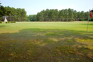
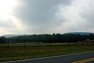
Alamance Battleground is a North Carolina State Historic Site commemorating the Battle of Alamance. The historic site is located south of Burlington, Alamance County, North Carolina in the United States.
Carolina is an unincorporated community located on the Haw River in Alamance County, North Carolina. It is located 4/5 mile east-southeast of Glencoe. It lies at an elevation of 591 feet.

Dogwood Acres is an unincorporated community in southeastern Orange County, North Carolina. It lies at an elevation of 423 feet .
Dogwood Acres, North Carolina may refer to:
Dogwood Acres is an unincorporated community in Cumberland County, North Carolina. It lies at an elevation of 171 feet.
Dogwood Acres is an unincorporated community in Rowan County, North Carolina. It lies at an elevation of 781 feet .
Dogwood Acres is a neighbourhood of Monroe, North Carolina in Union County, North Carolina. It lies at an elevation of 646 feet at the northwestern portion of the city.

Cedarock Park is a 414-acre (1.68 km2) nature preserve, historic farm, and passive-use park located near Bellemont in Alamance County, North Carolina.

The Battle of Alamance was the final battle of the War of the Regulation, a rebellion in colonial North Carolina over issues of taxation and local control. Some historians in the late nineteenth-early twentieth centuries considered the battle to be the opening salvo of the American Revolution, and locals agreed with this assessment. Yet, this has been questioned by present-day historians arguing that the Regulators were not intending a complete overthrow of His Majesty's Government in North Carolina. They were only standing up against those certain local officials who had become corrupt and unworthy tools of the King, and they only turned to riot and armed rebellion as a last resort when all other peaceful means through petitions, elections to the Assembly, etc. had failed to redress their grievances. Many surviving ex-Regulators became loyalists during the Revolution, and several anti-Regulators [e.g. William Hooper, Alexander Martin, and Francis Nash] became patriots during the Revolution. Named for nearby Great Alamance Creek, the battle took place in what was then Orange County and has since become Alamance County in the central Piedmont about 6 miles (9.7 km) south of present-day Burlington, North Carolina.
Wyatt Outlaw was the first African-American elected to be Town Commissioner and Constable of the town of Graham, North Carolina. He was lynched by the Ku Klux Klan on February 26, 1870. His death, along with the assassination of white Republican State Senator John W. Stephens at the Caswell County Courthouse, provoked Governor William Woods Holden to declare martial law in Alamance and Caswell Counties, resulting in the Kirk-Holden War of 1870.