Woodlawn, North Carolina

Last updated

Woodlawn, North Carolina
NCMap-doton-Woodlawn.PNG
Location of Woodlawn, North Carolina
Coordinates: 36°06′57″N79°17′23″W / 36.11583°N 79.28972°W / 36.11583; -79.28972
Country United States
State North Carolina
County Alamance
Area
[1]
  Total3.57 sq mi (9.24 km2)
  Land3.29 sq mi (8.53 km2)
  Water0.28 sq mi (0.71 km2)
Elevation
[2]
535 ft (163 m)
Population
 (2020)
  Total912
  Density276.87/sq mi (106.90/km2)
Time zone UTC-5 (Eastern (EST))
  Summer (DST) UTC-4 (EDT)
ZIP code
27302 [3]
Area code(s) 919 and 984
FIPS code 37-75375 [4]
GNIS feature ID2403039 [2]

Woodlawn is a census-designated place in Alamance County, North Carolina, United States.

Contents

Geography

According to the United States Census Bureau, the CDP has a total area of 3.7 square miles (9.5 km2), of which 3.4 square miles (8.9 km2) is land and 0.23 square miles (0.6 km2), or 6.60%, is water. [5]

Demographics

Historical population
CensusPop.Note
2020 912
U.S. Decennial Census [6]

As of the census [4] of 2000, there were 1,051 people, 408 households, and 321 families residing in the CDP. The population density was 210.7 inhabitants per square mile (81.4/km2). There were 431 housing units at an average density of 86.4 per square mile (33.4/km2). The racial makeup of the CDP was 76.50% White, 21.03% African American, 0.48% Native American, 0.38% from other races, and 1.62% from two or more races. Hispanic or Latino of any race were 1.05% of the population.

There were 408 households, out of which 33.3% had children under the age of 18 living with them, 65.0% were married couples living together, 10.0% had a female householder with no husband present, and 21.3% were non-families. 17.9% of all households were made up of individuals, and 7.8% had someone living alone who was 65 years of age or older. The average household size was 2.58 and the average family size was 2.94.

In the CDP, the population was spread out, with 23.9% under the age of 18, 5.3% from 18 to 24, 29.3% from 25 to 44, 29.0% from 45 to 64, and 12.5% who were 65 years of age or older. The median age was 41 years. For every 100 females, there were 101.0 males. For every 100 females age 18 and over, there were 95.6 males.

The median income for a household in the CDP was $54,130, and the median income for a family was $67,303. Males had a median income of $39,471 versus $33,864 for females. The per capita income for the CDP was $25,366. About 2.1% of families and 3.7% of the population were below the poverty line, including 2.2% of those under age 18 and none of those age 65 or over.

Related Research Articles

<span class="mw-page-title-main">Camp Pendleton Mainside, California</span> Census-designated place in California, United States

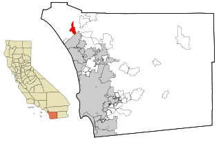
Camp Pendleton Mainside is a census-designated place (CDP) in San Diego County, California, located at the southeast corner of the Marine Corps Base Camp Pendleton. Per the 2020 census, the population was 9,683. It was formerly known as Camp Pendleton North, but its name was changed for the 2020 Census. Along with Camp Pendleton South, it is one of two CDPs located on the base.

<span class="mw-page-title-main">East Griffin, Georgia</span> CDP in Georgia, United States

East Griffin is a census-designated place (CDP) in Spalding County, Georgia, United States. The population was 1,635 at the 2000 census.

<span class="mw-page-title-main">Milford Mill, Maryland</span> Census-designated place in Maryland, United States

Milford Mill is an unincorporated community and census-designated place in Baltimore County, Maryland, United States. Per the 2020 census, the population was 30,622.

<span class="mw-page-title-main">Woodlawn, Prince George's County, Maryland</span> Census-designated place in Maryland

Woodlawn is an unincorporated area and census-designated place (CDP) in Prince George's County, Maryland, United States. As of the 2020 census it had a population of 7,541.

<span class="mw-page-title-main">Castle Point, Missouri</span> CDP in Missouri, United States

Castle Point is a census-designated place (CDP) in St. Louis County, Missouri, United States. The population was 3,962 at the 2010 census.

<span class="mw-page-title-main">Spring Hill, Pennsylvania</span>

Spring Hill is a census-designated place (CDP) in Cambria County, Pennsylvania, United States. The population was 839 at the 2010 census, down from 970 at the 2000 census.

<span class="mw-page-title-main">Clearwater, South Carolina</span> Census-designated place in South Carolina, United States of America

Clearwater is a census-designated place (CDP) in Aiken County, South Carolina. It lies near North Augusta, South Carolina, and is part of the Augusta, Georgia metropolitan area. Clearwater is located in historic Horse Creek Valley. The population was 4,370 at the time of the 2010 census.

<span class="mw-page-title-main">Gloverville, South Carolina</span> Census-designated place in South Carolina, United States of America

Gloverville is a census-designated place (CDP) in Aiken County, South Carolina, United States. The population was 2,831 at the 2010 census. It is part of the Augusta, Georgia metropolitan area. Gloverville is located in historic Horse Creek Valley.

<span class="mw-page-title-main">East Gaffney, South Carolina</span> Census-designated place in South Carolina, United States

East Gaffney is a census-designated place (CDP) in Cherokee County, South Carolina, United States. The population was 3,085 at the 2010 United States Census.

<span class="mw-page-title-main">Gantt, South Carolina</span> Census-designated place in South Carolina, United States

Gantt is a census-designated place (CDP) in Greenville County, South Carolina, United States. The population was 14,229 at the 2010 census. It is part of the Greenville–Mauldin–Easley Metropolitan Statistical Area and a suburb of the city of Greenville.

<span class="mw-page-title-main">Forestbrook, South Carolina</span> Census-designated place in South Carolina, United States

Forestbrook is a census-designated place (CDP) in Horry County, South Carolina, United States. The population was 4,612 at the 2010 census, up from 3,391 at the 2000 census.

<span class="mw-page-title-main">Red Hill, South Carolina</span> Census-designated place in South Carolina, United States

Red Hill is a census-designated place (CDP) in Horry County, South Carolina, United States. The population was 13,223 at the 2010 census, up from 10,509 at the 2000 census.

<span class="mw-page-title-main">Red Bank, South Carolina</span> Census-designated place in South Carolina, United States

Red Bank is an unincorporated community and census-designated place (CDP) in Lexington County, South Carolina, United States. The population was 9,617 at the 2010 census, up from 8,811 at the 2000 census. It is part of the Columbia, South Carolina Metropolitan Statistical Area.

<span class="mw-page-title-main">Modoc, South Carolina</span> CDP in South Carolina, United States

Modoc is a census-designated place (CDP) in McCormick County, South Carolina, United States. The population was 256 at the 2000 census, and 218 at the 2010 census, a decline of 14.8%.

Cane Savannah is a census-designated place (CDP) in Sumter County, South Carolina, United States. The population was 1,452 at the 2000 census. It is included in the Sumter, South Carolina Metropolitan Statistical Area.

Lakewood is a census-designated place (CDP) in Sumter County, South Carolina, United States. The population was 2,603 at the 2000 census. It is included in the Sumter, South Carolina Metropolitan Statistical Area.

<span class="mw-page-title-main">Mulberry, South Carolina</span> CDP in South Carolina, United States

Mulberry is a census-designated place (CDP) in Sumter County, South Carolina, United States. The population was 841 at the 2000 census. It is included in the Sumter, South Carolina Metropolitan Statistical Area.

Privateer is a census-designated place (CDP) in Sumter County, South Carolina, United States. The population was 2,118 at the 2000 census. It is included in the Sumter, South Carolina Metropolitan Statistical Area.

Shiloh is a census-designated place (CDP) in Sumter County, South Carolina, United States. The population was 259 at the 2000 census. It is included in the Sumter, South Carolina Metropolitan Statistical Area.

<span class="mw-page-title-main">Ladson, South Carolina</span> Census-designated place in South Carolina, United States

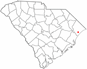
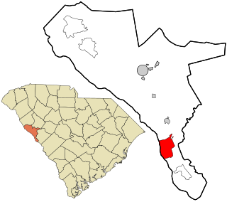
Ladson is a census-designated place (CDP) in Berkeley, Charleston and Dorchester counties in the U.S. state of South Carolina. The population was 13,790 at the 2010 census. It is named in honor of the Ladson family, one of the oldest planter and merchant families in the Charleston area; one of its members was lieutenant governor James Ladson.

References

  1. "ArcGIS REST Services Directory". United States Census Bureau. Retrieved September 20, 2022.
  2. 1 2 U.S. Geological Survey Geographic Names Information System: Woodlawn, North Carolina
  3. "Woodlawn NC ZIP Code". zipdatamaps.com. 2023. Retrieved February 17, 2023.
  4. 1 2 "U.S. Census website". United States Census Bureau . Retrieved January 31, 2008.
  5. "Geographic Identifiers: 2010 Demographic Profile Data (G001): Woodlawn CDP, North Carolina". U.S. Census Bureau, American Factfinder. Archived from the original on February 12, 2020. Retrieved July 2, 2013.
  6. "Census of Population and Housing". Census.gov. Retrieved June 4, 2016.