Doljani, Jablanica

Last updated
Doljani
Village
Doljani.jpg
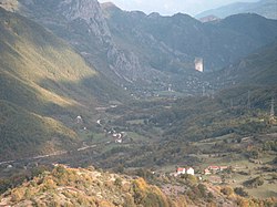
The view from the Obruč (Rim)
Bosnia and Herzegovina location map.svg
Red pog.svg
Doljani
Coordinates: 43°41′38″N17°39′37″E / 43.69389°N 17.66028°E / 43.69389; 17.66028
Country Flag of Bosnia and Herzegovina.svg  Bosnia and Herzegovina
Entity Federation of Bosnia and Herzegovina
Canton Flag of Herzegovina-Neretva.svg Herzegovina-Neretva
Municipality JablanicaGrb.gif Jablanica
Area
  Total
18.56 sq mi (48.07 km2)
Population
 (2013)
  Total
483
  Density26.0/sq mi (10.0/km2)
Time zone UTC+1 (CET)
  Summer (DST) UTC+2 (CEST)
Postal code
88420

Doljani is populated place in Jablanica Municipality, Bosnia and Hercegovina, between Jablanica and Mostar. This village lies along the Doljanka river (which was named after it) Doljani are located in the northern Herzegovina, in the northeastern part of the Nature Park "Blidinje". Elevation ranges from 600 to 750 meters in the place. The highest peaks that surround the village are Baćin (1,282 m), Borovinka (1430 m), and Vitlenica (1655 m) Throughout the Doljani valley flowing the river Doljanka. [1] [2]

Contents

History

Demography

Doljani
Total population in 2013: 568 [3]
Census Year199119811971
Croats 708 (67,49%)731 (69,68%)754 (71,80%)
Bosniaks 326 (31,07%)316 (30,12%)294 (28,00%)
Serbs 01 (0,09%)1 (0,09%)
Yugoslavians 10 (0,95%)00
Others and unknown5 (0,47%)1 (0,09%)1 (0,09%)
Total1,0491,0491.050

According to the 2013 census, its population was 483. [4]

Ethnicity in 2013
EthnicityNumberPercentage
Croats 29360.7%
Bosniaks 18638.5%
other/undeclared40.8%
Total483100%

See also

References

  1. Spahić M. et al. (2000): Bosna i Hercegovina (1:250.000). Izdavačko preduzeće "Sejtarija", Sarajevo.
  2. Mučibabić B., ed. (1998). Geografski atlas Bosne i Hercegovine. Geodetski zavod BiH. Sarajevo. ISBN   9958-766-00-0.{{cite book}}: CS1 maint: location missing publisher (link)
  3. "Nezavisna Agencija za Statistiku Bosne i Hercegovine, naselje Doljani". nasbih.com. Retrieved 11 January 2017.
  4. "Naseljena Mjesta 1991/2013" (in Bosnian). Statistical Office of Bosnia and Herzegovina . Retrieved September 28, 2021.