
The Donausteig is a hiking trail that passes through parts of Bavaria and Austria. Since the summer of 2010, the trail follows both banks of the Danube, from Passau via Linz up to St. Nikola and Grein.
The Donausteig is a hiking trail that passes through parts of Bavaria and Austria. Since the summer of 2010, the trail follows both banks of the Danube, from Passau via Linz up to St. Nikola and Grein.
The Donausteig trail is a non-alpine, long-distance trail. It has a length of around 450 km, with 23 stages, and it extends through 5 Bavarian and 40 Austrian municipalities. The Donausteig runs mostly through natural landscapes, and includes popular scenic spots and viewing areas. [1]
In addition to the main routes, 41 official Donausteig routes have been marked; 135 start, rest and viewing areas have been set up along the trail; and 4000 trail markers have been set up. In Passau, the route connects to the "Golden Trail", which was opened in 2007. [1]
As well as the Danube Cycle Path, the ‘Boat Trip along the Danube’ and ‘Culture on the Danube’, the Donausteig is a project created by the Danube Tourist Board of Upper Austria, with its 37 member municipalities. It was partly funded by the public purse (EU, Country, Municipality). [2]
The Donausteig leads through the Natura 2000 and Habitats Directive-protected areas Oberes Donau- und Aschachtal, where the landscape is characterized by hillside and ravine forests. It also runs through the bird sanctuary Oberes Donautal; the FFH- and the bird sanctuary Traun–Donau-Auen; the planned Natura 2000 and Northern Machland area; the nature protection areas Donauleiten in Bavaria und Pesenbachtal; Rannatal, the Tal des Kleinen Kößlbaches, and Castle Neuhaus.
Among the points of interest along the trail are the Strudengau with the Stillensteinklamm, the Wolfschlucht near Bad Kreuzen, the Floodplains of the Northern Machland, the Klamschlucht, the Pesenbachtal, the Obere Donautal Oberösterreichs with the Schlögener Schlinge, the Rannatal and the Tal des Kleinen Kößlbachs. [2]
The Donausteig trail runs along the Danube River, starting in Passau and passing through Linz, the former European Capital of Culture, to Grein, an Upper Austrian town with an altitude of 218 meters above sea level, the lowest in the region.
In several day-long sections, hiking enthusiasts can walk along the Donausteig’s 450 kilometers-long track. Starting in Passau and passing the chapel Maria am Walde , one arrives at Freinberg, from where one can enjoy the Dreiflüsseblick , an elevated view of the surrounding area. From there, the path leads through the nature reserve called Kleines Kößlbachtal , past the Donauleiten and towards Vichtenstein. The Donausteig then leads right alongside the Danube to Wesenufer. From there it continues to the Vier-Viertel-Blick and the Schlögener Blick, offering a great view of the boldest natural highlight of the Donausteig: the Schlögener Schlinge. From Aschach, the hiking trail then leads up to the castle ruin Burgruine Schaunberg, to Eferding and Wilhering. From there one has the possibility to cross the Danube on a ferry to Ottensheim.
The next section of the Donausteig trail contains several highlights such as the Pöstlingberg , which has one of the steepest adhesion railways in all over Europe: the Pöstlingbergbahn . The next big stop along the trail is Linz, which offers interesting sightseeing spots such as its historic old town, the new and old dome, the baroque Linzer Hauptplatz (town square), the Ars Electronica Center, the Lentos Art Museum, the Castle Museum Linz, the city museum Nordico, the Brucknerhaus, the Linz State Theatre and the Voestalpine Stahlwelt .
Starting in Linz, one can follow the gravel paths leading through the cultural landscape to Rohrbach, St. Florian and eventually Enns. Taking the ferry from Enghagen, one can reach Mauthausen and hike through the flat landscape along field paths on to Perg. From the town's central square the Donausteig continues to Baumgartenberg, to Saxen via the Burg Clam and the Klamschlucht, and eventually to Grein via the Gobelwarte. The final legs of the trail lead the hiker via St. Nikola and Sarmingstein to Waldhausen and finally back to Grein via Bad Kreuzen.
The 41 Donausteigrunden were created for frequent hikers. They branch off from the main route of the Donausteig and lead into the more remote countryside and to numerous viewing points.
The starting point for the Bauern- und Holzknechtrunde (farmers and woodcutters tour) is the ferry terminal at Wilhering. From the main road, in direction of Linz, the circular trail runs through the center of the town and onto a field path. From a little hill a beautiful view across Ottensheim and Wilhering can be enjoyed. The trail continues from there uphill through the Kürnberger forest and then downhill again on a wooden natural trail to the settlement of Mühlbach. Over plain fields and small hills the trail leads back to the Danube. At the Ottensheim-Wilhering power station, the circular trail reconnects with the Donausteigand leads back to Wilhering.
Starting point is the information board Donaussteig/Urfahrmarkt, adjacent to the Ars Electronica Center. From here a direct view down Linz's cultural mile can be enjoyed, with the Lentos Art Museum, the Brucknerhaus and the Linz Castle. The trail then leads alongside the Danube to the new town hall, before arriving at the street Obere Donaustraße. Subsequently, the trail crosses the path of the Pöstlingbergbahn , the steepest adhesion railway in Europe. Turning left, the path continues along the Schablederweg, which runs alongside the tracks of the Pöstlingbergbahn for the most part. Not far from here, the zoo Linzer Tiergarten welcomes animal lovers. The trail continues all the way up to the 537 meter high Pöstlingberg , which is also dubbed Acropolis of Linz. The Linzer Grottenbahn fairy-tale grotto, the baroque Wallfahrtsbasilika and the rose garden are further points of interest along the way. The Grottenbahn runs through a colourful fairytale world with scenes from famous fairytales on display. In the lower part of the fortification tower, one can find a miniature model of what the town's main square looked like in 1900. The panorama terrace Sieben Schmerzen Mariä offers a grand view of Linz. Via a steep path the Collegium Petrinum, an episcopal high school that was founded at the end of the 19th century, can be reached. From there the trail leads back to the information board at the Ars Electronica Center. After the hike, it seems legitimate to explore the nearby old town of Linz, which is easily accessible via the Nibelungenbrücke bridge.
Out of the 45 municipalities that can be found on the Danube trail, five are in Bavaria (Germany) and 40 are in Upper Austria.
The trail runs through a total of seven upper Austrian ‘leader regions’ (from West to East): Sauwald, Donau-Böhmerwald, Hausruck Nord, Eferding, Urfahr-West, Linz-Land and Strudengau.
A description of the trail routes which start in the respective municipality is given in brackets. [3]

Linz is the capital of Upper Austria and third-largest city in Austria. In the north of the country, it is on the Danube 30 km (19 mi), south of the Czech border. In 2018, the population was 204,846. In 2009, it received the title of European Capital of Culture.

Montafon is a 39 km long valley in the westernmost Austrian federal state of Vorarlberg.
The Rheinsteig is a hiking trail following a mainly elevated path along the east bank of the Rhine River in Germany. Its 320 kilometres (200 mi) route stretches from Bonn to Wiesbaden, running parallel to the Rheinhöhenweg Trail and Rheinburgenweg Trail.
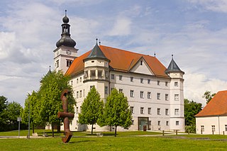
Schloss Hartheim, also known as Hartheim Castle, is a castle at Alkoven in Upper Austria, some 14 kilometres (9 mi) from Linz, Austria. It was built by Jakob von Aspen in 1600, and it is a prominent Renaissance castle in the country.

The Battle of Ebelsberg, known in French accounts as the Battle of Ebersberg, was fought on 3 May 1809 during the War of the Fifth Coalition, part of the Napoleonic Wars. The Austrian left wing under the command of Johann von Hiller took up positions at Ebersberg on the Traun river. The French under André Masséna attacked, crossing a heavily defended 550-meter-long bridge and subsequently conquering the local castle, thus forcing Hiller to withdraw. Ebelsberg is now a southern suburb of Linz, situated on the south bank of the Traun, a short distance above the place where that stream flows into the Danube River.

Devínska Kobyla is the highest peak in the Devín Carpathians, part of the Little Carpathians mountain range, and the highest point of Bratislava, the capital of Slovakia. It is located between the boroughs of Devínska Nová Ves, Devín and Dúbravka, close to the border with Austria. Its peak elevation is 514 m (1686.3 ft) AMSL and its treeless summit contains an abandoned military missile base that is officially inaccessible to the public.

The National Blue Trail is a national trail in Hungary, for most of its length part of the European Long Distance Walking Route E4. The route starts atop the Írott-kő Mountain on the Austrian-Hungarian border then leads across Hungary eventually ending 1,170 km later at the village of Hollóháza by the Hungarian-Slovakian border.. The name of the Kéktúra is a reference to the marking of the path itself: it is a horizontal blue stripe on a white rectangle. All segments of the trail are freely accessible to the public; no fees have to be paid or permits obtained, there is only one ferry to take over the Danube between Visegrád and Nagymaros where you have to purchase a ticket. Although to have an official completion, you have to purchase a stamping brochure from MTSZ, the organizer of the trail.

Rheinbrohl is a municipality in the territorial collectivity of Bad Hönningen, in the district of Neuwied, in Rhineland-Palatinate, in western Germany. On its Rhine bank is the starting point of the Upper Germanic-Rhaetian Limes, the fortification of 550 km length which delimited the Roman Empire. At this place near the Rhine is the reconstruction of a Roman watchtower.
Eferding is the capital of the Eferding district in the Austrian state of Upper Austria.
EuroVelo 6 (EV6), named the "Rivers Route", is a EuroVelo long-distance cycling route that runs along 3,653 km (2,270 mi) some of Europe's major rivers, including much of the Loire, some of the Saône, a short section of the upper Rhine and almost the entire length of Europe’s second longest river, the Danube — from the Atlantic coast of France to the city of Constanța on the Black Sea.

The Danube is the second-longest river in Europe, after the Volga in Russia. It flows through much of Central and Southeastern Europe, from the Black Forest south into the Black Sea. A large and historically important river, it was once a frontier of the Roman Empire. In the 21st century, it connects ten European countries, running through their territories or marking a border. Originating in Germany, the Danube flows southeast for 2,850 km (1,770 mi), passing through or bordering Austria, Slovakia, Hungary, Croatia, Serbia, Romania, Bulgaria, Moldova, and Ukraine. Among the many cities on the river are four national capitals: Vienna, Bratislava, Budapest, and Belgrade. Its drainage basin amounts to 817 000 km² and extends into nine more countries.

Burgruine Federaun is a castle in Carinthia, Austria.

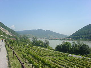
The Wachau is an Austrian valley with a picturesque landscape formed by the Danube river. It is one of the most prominent tourist destinations of Lower Austria, located midway between the towns of Melk and Krems that also attracts "connoisseurs and epicureans" for its high-quality wines. It is 36 kilometres (22 mi) in length and was already settled in prehistoric times. A well-known place and tourist attraction is Dürnstein, where King Richard I of England was held captive by Leopold V, Duke of Austria. The architectural elegance of its ancient monasteries, castles and ruins combined with the urban architecture of its towns and villages, and the cultivation of vines as an important agricultural produce are the dominant features of the valley.

EuroVelo 7 (EV7), named the Sun Route, is a 7,409 km (4,604 mi) long EuroVelo long-distance cycling route running north–south through the whole of Europe from the North Cape in Norway to the island of Malta in the Mediterranean Sea. The route passes through nine countries, and from north to south these are: Norway, Finland, Sweden, Denmark, Germany, Czech Republic, Austria, Italy, Malta.

Rottenegg Castle is a ruined castle near the village of Rottenegg in the municipality of Sankt Gotthard im Mühlkreis, Austria. It dates to the 13th century, and was built to protect a medieval trade route. After 1712 the castle was allowed to decay, and much of it has disappeared.

The earliest Austrian walled towns started to appear in the late 11th century to the early 13th century. Their establishment was closely connected with the development of Austria as a march of the Holy Roman Empire and in particular by the Hohenstaufen emperors and their Marcher Lords, the Babenbergs. In present-day Austria, there are 106 towns or cities that were walled. The walls of Radstadt, Freiburg, Hainburg and Drosendorf survive almost intact, and Austria has some of the most impressive walled towns in Europe.

The County of Schaunberg was a state of the Holy Roman Empire, located in present-day Upper Austria. It roughly corresponded to the modern Hausruckviertel. Its seat was the castle of Schaunberg, Hartkirchen.
The Gießenbach is a river of Austria. Its drainage basin is 64 km2 (25 sq mi).
The Freinberg is a mountain with an elevation of 405 meters above sea level, situated in the urban area of the Upper Austrian capital, Linz. Historically, this mountain plateau and the forested ridge to the south were known by different names, including Galgenberg and Jägermayrwald. The Freinberg offers panoramic views of almost the entire city of Linz.