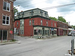
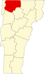
Richford is a town in Franklin County, Vermont, United States, located along the Canada–United States border. The population was 2,346 at the 2020 census.

The Waterville Village Historic District encompasses most of the history 19th and early 20th-century village center of Waterville, Vermont. The village grew from beginnings late in the 18th century to serve as a modest civic, commercial, and residential hub for the rural community. It was added to the National Register of Historic Places in 2007.
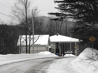
The East Richford–Glen Sutton Border Crossing connects the towns of Sutton, Quebec and Richford, Vermont on the Canada–US border. During the early 20th century, this scenic road was a major east–west thoroughfare. In 1936, the United States built a large border station that is still in use today, and is listed on the National Register of Historic Places. By coincidence, the actual border crossing is on the Missisquoi River Bridge, built in 1929 and also listed on the US National Register. The original bridge, built in 1926, was destroyed only a year later in the Great Vermont Flood of 1927. The US station is open 24 hours; the Canadian station is open daily from 8:00am to 4:00pm.

The Exeter Waterfront Commercial Historic District encompasses the historic commercial and residential waterfront areas of Exeter, New Hampshire. The district extends along the north side of Water Street, roughly from Main Street to Front Street, and then along both sides of Water and High streets to the latter's junction with Portsmouth Street. It also includes properties on Chestnut Street on the north side of the Squamscott River. This area was where the early settlement of Exeter took place in 1638, and soon developed as a shipbuilding center. The district was listed on the National Register of Historic Places in 1980. It was enlarged in 1986 to include the mill complex of the Exeter Manufacturing Company on Chestnut Street.

The Newmarket Industrial and Commercial Historic District encompasses the heart of a distinctive 19th century mill town, Newmarket, New Hampshire. Its mill complex is regionally distinctive for its extensive use of stone from an early date, and the town is relatively well-preserved due to a significant economic decline after the mills closed in 1920. The district was listed on the National Register of Historic Places in 1980. The Stone School, listed in 1978, is a contributing resource.

The Tilton Downtown Historic District encompasses a roughly one-block section of Main Street in the center of Tilton, New Hampshire. It extends from Central Street in the west to Bridge and School Streets in the east, including all of the buildings on the north side of this section, and a cluster of buildings on the south side near Bridge Street. The area has long been a commercial and industrial center for the town, although most of the buildings now date from the late 19th century onward, and include a fine array of Victorian architecture. The district was listed on the National Register of Historic Places in 1983.

The Brattleboro Downtown Historic District encompasses most of the central business district of the town of Brattleboro, Vermont. Extending along Main Street between Whetstone Brook and a junction with Pultney Road and Linden and Walnut Streets, this area includes many of the town's prominent civic and institutional buildings. The area's development took place primarily in the 19th century, with surviving buildings from both the 18th and early 20th centuries. The district was listed on the National Register of Historic Places in 1983, and was enlarged in 2004 to include Plaza Park and the Holstein Building on the south side of Whetstone Brook.

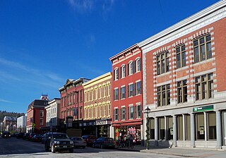
The Downtown Bennington Historic District encompasses the historic commercial heart of Bennington, Vermont. Centered on the junction of Main, South, and North Streets, it exhibits a variety of commercial architectural styles from the early 19th to mid-20th century. It was listed on the National Register of Historic Places in 1980, and was enlarged in 2008.

The Fair Haven Green Historic District encompasses the village green of Fair Haven, Vermont, and the heterogeneous collection of civic, commercial, and residential buildings that line it and adjacent streets. The area was developed mainly following the arrival of the railroad in 1848 and the subsequent expansion of marble and slate quarries in the area. The district was listed on the National Register of Historic Places in 1980.

The Bethel Village Historic District encompasses the historic core of the village of Bethel in the town of Bethel, Vermont, USA. The L-shaped district extends along Main and Church Streets, including many of the village's commercial and civic buildings, as well as a significant number of 19th and early 20th-century residences. The district was listed on the National Register of Historic Places in 1976, and was slightly enlarged in 1990.

The Depot Square Historic District encompasses the historic commercial business district of Randolph, Vermont. Developed in the mid-19th century around the facilities of the Central Vermont Railway, the area features a high concentration of well-preserved Second Empire and late Victorian commercial architecture. It was listed on the National Register of Historic Places in 1975.

The South Royalton Historic District encompasses the central portion of the village of South Royalton, Vermont. Now the town of Royalton's principal commercial center, it developed in the second half of the 19th century around the depot of the Vermont Central Railroad. The district includes fine examples of Greek Revival and Victorian architecture, and is home to the Vermont Law School. It was listed on the National Register of Historic Places in 1976.

The Springfield Downtown Historic District encompasses the historic central business district of the town of Springfield, Vermont. Located in a narrow valley on the banks of the Black River, the town's architecture is primarily reflective of its importance as a manufacturing center in the late 19th and early-to-mid 20th centuries, with a cluster of commercial buildings surrounded by residential and industrial areas. It was listed on the National Register of Historic Places in 1983, and enlarged slightly in 1986.

The Weston Village Historic District encompasses the town center and principal village of Weston, Vermont. Centered on Farrar Park, which serves as the town green, it includes a diversity of architectural styles from the late 18th century to about 1935, and includes residential, civic, commercial, industrial and religious buildings. It was listed on the National Register of Historic Places in 1985.

The Bristol Downtown Historic District encompasses the historic late 19th-century commercial heart of Bristol, Vermont. At first a rural agricultural market town, it developed in the second half of the 19th century as a small industrial center, producing finished wood products. Its downtown occupies an area of one block on both sides of Main Street, and features a diversity of architectural styles. It was listed on the National Register of Historic Places in 1983.

The Downtown Essex Junction Commercial Historic District encompasses the historically railroad-dominated portion of downtown Essex Junction, Vermont. Aligned along the south side of Railroad Avenue and adjacent portions of Main Street, the area underwent most of its development between 1900 and 1940, when Essex Junction served as a major regional railroad hub. The district was listed on the National Register of Historic Places in 2004.
The Montpelier Historic District encompasses much of the historic commercial and government district of Montpelier, the state capital of Vermont. The city center, focused on the confluence of the Winooski River with its North Branch, has been economically driven by state government since 1805, and had industry powered by the rivers. Its center reflects a diversity of 19th century architecture. In addition to the Vermont State House, the district includes The Pavilion, the commercial downtown area, and residential areas to the east and north. It was listed on the National Register of Historic Places in 1978, and enlarged in 1989 and 2018.

The Richford Primary School is a historic school building at 140 Intervale Avenue in Richford, Vermont. Built in 1903 to address an overcrowding problem in the local schools, it served the town until 1968, and has since been converted into residential use. It was listed on the National Register of Historic Places in 2004.

The Sweat-Comings Company House is a historic two-family house at 10–12 Powell Street in Richford, Vermont. Built in 1909, it is a rare surviving example of an early company-built boarding house. It was sold into private ownership in 1924, and is a good local example of vernacular Colonial Revival architecture. It was listed on the National Register of Historic Places in 2004.

The Railroad Street Historic District encompasses a cluster of commercial and railroad-related buildings at the traditional late 19th-century heart of St. Johnsbury, Vermont. It includes five commercial buildings and the town's 1883 union depot, and is reflective of the town's importance as a major railroad junction in northern New England. The district was listed on the National Register of Historic Places in 1974. It was subsumed by the larger St. Johnsbury Historic District in 1980.