The Church Street Covered Bridge, also called the Village Covered Bridge, is a wooden covered bridge that crosses the North Branch of the Lamoille River in Waterville, Vermont off State Route 109. Built in the late 19th century, it is one of five covered bridges in a space of about five miles that cross the North Branch Lamoille. It was listed on the National Register of Historic Places in 1974.

The Maple Street Covered Bridge, also called the Lower Covered Bridge and the Fairfax Covered Bridge, is a covered bridge that carries Maple Street across Mill Brook off State Route 104 in Fairfax, Vermont. Built in 1865, it is the town's only historic covered bridge, and is a rare two-lane covered bridge in the state. It was listed on the National Register of Historic Places in 1974.

The Cedar Swamp Covered Bridge, also known as the Station Bridge and by various other names, was a historic wooden covered bridge spanning Otter Creek between Cornwall and Salisbury, Vermont. The Town lattice truss bridge was built in 1864-1865 and added to the National Register of Historic Places in 1974. It was destroyed by fire in September 2016.

Quinlan's Covered Bridge, also called the Quinlan Covered Bridge, or colloquially known as the Lower Covered Bridge, and Sherman Covered Bridge is a wooden covered bridge that crosses Lewis Creek in Charlotte, Vermont on Monkton Road. It was listed on the National Register of Historic Places in 1974. It is one of nine 19th-century Burr arch covered bridges in the state.

The Slaughter HouseCovered Bridge is a wooden covered bridge that carries Slaughterhouse Road across the Dog River in Northfield, Vermont. The Queen post truss bridge is one of five surviving 19th-century bridges in the town. It was listed on the National Register of Historic Places in 1974.

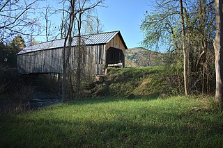
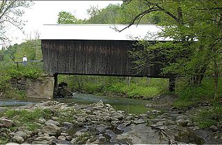
The Longley Covered Bridge, also known as the Harnois Covered Bridge, is a wooden covered bridge that crosses the Trout River in Montgomery, Vermont on Longley Bridge Road. Built in 1863, this Town lattice truss bridge is the oldest of a group of area bridges built by brothers Sheldon & Savannah Jewett. It was listed on the National Register of Historic Places in 1974. The bridge is closed to traffic, and has been bypassed by an adjacent temporary bridge.

The Mill Covered Bridge is a wooden covered bridge that crosses the North Branch Lamoille River on Back Road in Belvidere, Vermont. Built about 1890, it is one of two surviving covered bridges in the rural community. It was listed on the National Register of Historic Places in 1974.

The Hammond Covered Bridge is a Town lattice covered bridge spanning Otter Creek in Pittsford, Vermont. The bridge was built in 1842 by Asa Norse, and originally carried Kendall Hill Road, which now passes just to its south. The bridge was added to the National Register of Historic Places on January 21, 1974.
The Flint Covered Bridge is a historic covered bridge carrying Bicknell Hill Road over the First Branch White River in northern Tunbridge, Vermont. Built in 1845, it is the oldest of five 19th-century covered bridges in Tunbridge, representing one of the highest concentrations of covered bridges in the state. It was listed on the National Register of Historic Places on September 10, 1974.

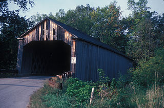
The Waterman Covered Bridge was an historic covered bridge in Johnson, Vermont that carried Waterman Road across Waterman Creek. Built in 1868, it was one of three surviving 19th-century bridges in the town. It was listed on the National Register of Historic Places in 1974, and collapsed in January 1982.

The Dean Covered Bridge was a Town lattice truss covered bridge, carrying Union Street across Otter Creek in Brandon, Vermont. Built in 1840, it was one of Vermont's oldest covered bridges at the time of its destruction in 1986 by an arsonist. It was listed on the National Register of Historic Places, and was replaced by a modern steel and concrete bridge.
The Sanderson Covered Bridge is a historic covered bridge, which carries Pearl Street over Otter Creek in Brandon, Vermont. Built about 1840, it is one of Vermont's oldest covered bridges, and is the only remaining 19th century bridge in Brandon. It was listed on the National Register of Historic Places in 1974.
The Howe Covered Bridge is a historic covered bridge carrying Belknap Brook Road across the White River in Tunbridge, Vermont, just east of Vermont Route 110. Built in 1879, it is one of five surviving bridges in the town, one of the highest concentrations of covered bridges in the state. It was listed on the National Register of Historic Places in 1974.
The Moxley Covered Bridge is a historic covered bridge carrying Moxley Road across the First Branch White River in southern Chelsea, Vermont. Built in 1886-87, it is the town's only surviving 19th-century covered bridge. It was listed on the National Register of Historic Places in 1974.

The Upper Falls Covered Bridge, also known as the Downers Covered Bridge, spans the Black River, carrying Upper Falls Road just south of Vermont Route 131 in western Weathersfield, Vermont. The Town lattice truss bridge was built in 1840 and rebuilt in 2008. Its gable ends are distinctive for their Greek Revival styling. The bridge was listed on the National Register of Historic Places in 1973.

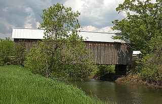
The Union Village Covered Bridge is a historic covered bridge, carrying Academy Road across the Ompompanoosuc River in Union Village, Thetford, Vermont. Built in 1867, it is the state's longest 19th-century multiple kingpost truss bridge. It was listed on the National Register of Historic Places in 1974.

The East Shoreham Covered Railroad Bridge is a historic covered bridge spanning the Lemon Fair River near East Shoreham, Vermont. Built in 1897 by the Rutland Railroad Company, it is the state's only surviving example of a wooden Howe truss railroad bridge. It was listed on the National Register of Historic Places in 1974.

The Martin Covered Bridge is a wooden covered bridge spanning the Winooski River off United States Route 2 in southern Marshfield, Vermont. Built about 1890, it is the only surviving historic covered bridge in the town. It was listed on the National Register of Historic Places in 1974.

The Burrington Covered Bridge is a historic queenpost truss covered bridge in Lyndon, Vermont. Built in the 19th century, it is one of five covered bridges in Lyndon. It formerly carried Burrington Bridge Road across the Passumpsic River; it has been bypassed by a modern bridge. It was listed on the National Register of Historic Places in 1974.

The Centre Covered Bridge, also known as the Sanborn Covered Bridge, is a historic covered bridge, spanning the Passumpsic River next to U.S. Route 5 (US 5) north of the village of Lyndonville, Vermont. Built in 1872, it was moved to its present location and taken out of service in 1960. The bridge was located on Center Street between Lyndonville and Lyndon Center. It is one of three surviving Paddle-Ford truss bridges in Vermont. It was listed on the National Register of Historic Places in 1974. An amended National Register of Historic Places registration form was accepted by the National Park Service in 2024. The amendment fully documents the history and significance of the Centre Covered Bridge and lists it at the national level of significance.