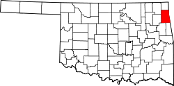
Drowning Creek, Oklahoma | |
---|---|
Coordinates: 36°28′40″N94°53′39″W / 36.47778°N 94.89417°W [1] | |
Country | United States |
State | Oklahoma |
County | Delaware |
Area | |
• Total | 0.89 sq mi (2.30 km2) |
• Land | 0.89 sq mi (2.30 km2) |
• Water | 0.00 sq mi (0.00 km2) |
Elevation | 837 ft (255 m) |
Population (2020) | |
• Total | 174 |
• Density | 195.95/sq mi (75.62/km2) |
Time zone | UTC-6 (Central (CST)) |
• Summer (DST) | UTC-5 (CDT) |
FIPS code | 40-21676 [3] |
GNIS feature ID | 2584378 [1] |
Drowning Creek is an unincorporated community and census-designated place (CDP) in Delaware County, Oklahoma, United States. The population was 155 at the 2010 census. [3]
Drowning Creek is located northwest of the center of Delaware County, at the eastern end of an arm of the Grand Lake o' the Cherokees, in the valley of Drowning Creek. It is 6 miles (10 km) northwest of Jay, the county seat.
According to the United States Census Bureau, the Drowning Creek CDP has a total area of 0.89 square miles (2.3 km2), all land. [3]
Census | Pop. | Note | %± |
---|---|---|---|
2020 | 174 | — | |
U.S. Decennial Census [4] |
Delaware County is a county located in the U.S. state of Oklahoma. As of the 2020 census, the population was 40,397. Its county seat is Jay. The county was named for the Delaware Indians, who had established a village in the area prior to the Cherokees being assigned to relocate to Indian Territory in the 1830s. Delaware County was created in 1907. Prior to becoming Delaware County, a large portion of the area was known as the Delaware District of the Cherokee Nation. Today, Delaware County continues to be recognized by the Cherokee Nation as the Delaware District.
Brush Creek is an unincorporated community and census-designated place (CDP) in Delaware County, Oklahoma, United States. The population was 35 at the 2010 census.
Bull Hollow is an unincorporated community and census-designated place (CDP) in Delaware County, Oklahoma, United States. The population was 67 at the 2010 census.
Cloud Creek is an unincorporated community and census-designated place (CDP) in Delaware County, Oklahoma, United States. The population was 121 at the 2010 census, a 40.7 percent increase over the figure of 86 recorded in 2000 census.
Copeland is an unincorporated community and census-designated place (CDP) in Delaware County, Oklahoma, United States. The population was 1,629 at the 2010 census, a 12.5 percent increase from the figure of 1,448 recorded in 2000. Founded as a railroad community, it was named for local resident D.R. Copeland.
Dennis is an unincorporated community and census-designated place (CDP) in Delaware County, Oklahoma, near Grand Lake. The population was 195 at the 2010 census. The Dennis Post Office existed from March 25, 1914, until January 31, 1956. It is said to be named for a local resident, Peter Dennis.
Flint Creek is an unincorporated area and census-designated place (CDP) in Delaware County, Oklahoma, United States. The population was 732 at the 2010 census, up from 580 in 2000.
Rocky Ford is a census-designated place (CDP) in Delaware and Cherokee counties, Oklahoma, United States. The population was 283 as of the 2020 Census, a whopping 464% increase over the population of 61 reported at the 2010 census.
Oakhurst is an unincorporated community and census-designated place (CDP) in Creek and Tulsa counties in the U.S. state of Oklahoma. The population was 2,262 at the 2020 census, a slight increase from the 2010 population of 2,185.
Chadds Ford is a census-designated place (CDP) in Delaware and Chester counties, Pennsylvania, United States, comprising the unincorporated communities of Chadds Ford and Chadds Ford Knoll. It was first listed as a CDP prior to the 2020 census.
New Tripoli is an unincorporated community and census-designated place (CDP) in Lynn Township in Lehigh County, Pennsylvania. As of the 2020 census, the population was 840. New Tripoli is part of the Lehigh Valley, which had a population of 861,899 and was the 68th-most populous metropolitan area in the U.S. as of the 2020 census.
Yardville is an unincorporated community and census-designated place (CDP) in Hamilton Township, Mercer County, New Jersey, United States. As of the 2020 United States census, the CDP's population was 6,965. Before the 2010 census, the area was part of the Yardville-Groveville CDP.
Kenwood is an unincorporated community and census-designated place (CDP) in Delaware and Mayes counties, Oklahoma, United States. As of the 2010 census it had a population of 1,224.
Teresita is an unincorporated community and census-designated place (CDP) in Cherokee County, Oklahoma, United States. The population was 188 as of the 2020 Census, up from the population of 159 reported at the 2010 census.
Butler is an unincorporated community and census-designated place (CDP) in Delaware County, Oklahoma, United States. The population was 117 at the 2010 census.
Deer Lick is an unincorporated community and census-designated place (CDP) in Delaware County, Oklahoma, United States. The population was 46 at the 2010 census.
Indianola is an unincorporated area and census-designated place (CDP) in Delaware County, Oklahoma, United States. The population was 48 at the 2010 census.
White Water is a census-designated place (CDP) in Delaware County, Oklahoma, United States. The population was 80 at the 2010 census.
Prattsville is a hamlet and census-designated place (CDP) in the town of Prattsville, Greene County, New York, United States. The population of the CDP was 384 at the 2020 census, out of a total population of 774 in the town in 2020.
Oak Hill-Piney is a census-designated place (CDP) in Delaware County, Oklahoma, United States. It was first listed as a CDP prior to the 2020 census.