
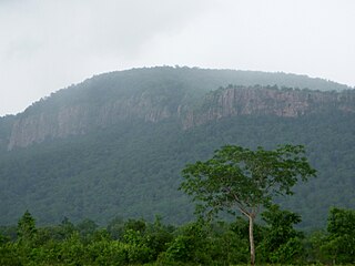
Khammam, also known as Khammamett is the city in Khammam district of the Indian state of Telangana. It is the fourth largest city in the state. It is the headquarters of the Khammam district and Khammam mandal also. It is located about 193 kilometres (120 mi) east of the state capital, Hyderabad, 61 kilometres (38 mi) from Suryapet, 120 kilometres (75 mi) from Warangal and also it is located about 121 kilometres (75 mi) North of the Andhra Pradesh state capital, Amaravathi. The river Munneru flows on the western side of the city. As of 2011 census of India, Khammam urban agglomeration has a population of 313,504. However, on 19 October 2012, the civic body of Khammam was upgraded to Municipal corporation Post upgradation to corporation Khammam population is approximated to be 3,07,000.

Bhadrachalam is a census town in the Indian state of Telangana, Bhadradri Kothagudem district. It is an important Hindu pilgrimage town with the Bhadrachalam Temple of Lord Rama, situated on the banks of Godavari river. It is located 312 kilometres (194 mi) from east of state capital, Hyderabad,115 kilometres (71 mi) from Khammam,192 kilometres (119 mi) from Vijayawada,177 kilometres (110 mi) from Suryapet, 180 kilometres (112 mi) from Warangal, 220 kilometres (137 mi), from the Andhra Pradesh State Capital Amaravathi, 350 kilometres (217 mi) from Visakhapatnam.

Banapuram is a small village located 30 km from Khammam district headquarters in Telangana, India. Administratively Khammam is divided into 42 revenue divisions. This village comes in Mudigonda revenue division. Literacy rate is around 60%.
Khammam district is a district in the eastern region of the Indian state of Telangana. The city of Khammam is the district headquarters. The district shares boundaries with Suryapet, Mahabubabad, Bhadradri districts and with Andhra pradesh state.

Suryapet(listen) is a city in the Indian state of Telangana. It is a municipality and the headquarters of its eponymous district. The Government of India announced Suryapet to be developed under the Atal Mission for Rejuvenation and Urban Transformation (AMRUT) scheme. Suryapet has been awarded the "Cleanest city" in South India by the Ministry of Urban development in Swachh Survekshan 2017. It is also known as "Gateway of Telangana". It is located about 134 kilometres (83 mi) east of the state capital, Hyderabad and also it is located about 138 kilometres (86 mi) West of Vijayawada.

Manuguru is a census town and mandal in Bhadradri Kothagudem district in the Indian state of Telangana. It comes under Mahaboobabad parliamentary constituency and Pinapaka Assembly constituency. Manuguru is an urban area, situated on the banks of Godavari River. The town is famous for Singareni coal mines. The singareni had provided many employment opportunities. Since there is a availability of coal the TS government has taken an action to construct a power plant(BTPS) in the coal city MANUGURU Pin code of Manuguru is 507117.
Bheemavaram is a village in Khammam district of the Indian state of Telangana. It is located in Yerrupalem mandal of Khammam revenue division.

Sathupalli is a town in Khammam district of the Indian state of Telangana. It is a Municipality in Sathupally mandal of Khammam revenue division. It is situated approximately 276 km (171 mi) east of Hyderabad, 80 km (50 mi) from Khammam and 200 km (120 mi) from Warangal. It is about 135 km (84 mi) north of Amaravati, the state capital of Andhra Pradesh, and 126 km (78 mi) west of Rajahmundry.

Penuganchiprolu is a village in Krishna district of the Indian state of Andhra Pradesh. It is the mandal headquarters of Penuganchiprolu mandal in Vijayawada revenue division.
This page is about Kandukuru, Khammam district. For other uses, see Kandukuru
Chirunomula is a small village located in Bonakal Mandal of Khammam district, Telangana, India.
Kusumanchi is a village in Khammam district of Telangana in India. It is the headquarters of Kusumanchi mandal.

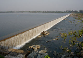
Munneru is a left tributary of the Krishna River. It originates in Warangal District of Telangana, India and flows in the districts of Khammam District and Krishna District. The river is named after Rishi Maudgalya, who is said to have created this river with his spiritual power and performed a penance ritual in Khammam.

Jaggayyapeta mandal is one of the 50 mandals in Krishna district of the state of Andhra Pradesh in India. It is under the administration of Vijayawada revenue division and the headquarters are located at Jaggayyapeta town. Krishna River flows through the mandal and is bounded by Penuganchiprolu, Nandigama, Chandarlapadu mandals of Krishna district, some part of Guntur district, Nalgonda and Khammam districts of Telangana.
Bhimadole mandal is one of the 46 mandals in West Godavari district of the Indian state of Andhra Pradesh. It is administered under Eluru revenue division and its headquarters are located at Bhimadole.
Mothugudem is a village in the East godavari district of the Indian state of Andhra pradesh. It is located in Chintur mandal.
Khammam (urban) mandal is one of the 46 mandals in Khammam district of the Indian state of Telangana. It is under the administration of Khammam revenue division and has its headquarters at Khammam. The mandal is bounded by Kamepalli, Enkuru, Konijerla, Khammam (rural) and Chintakani mandals.
Bhadradri Kothagudem district is a district in the eastern region of the Indian state of Telangana. The town of Kothagudem is the district headquarters..In terms of area, Bhadradri Kothagudem is the largest district with an area of 7,483 km2 in the state.The district share boundaries with Khammam, Mahabubabad and Mulugu and withe state boundary of Chhattisgarh and Andhra Pradesh.
Remidicherla is a small village in Yerrupalem Mandal of Khammam District. It is the second-most populated village in Yerrupalem Mandal.

