
Karimnagar is also known as Elagandula is a city and District Headquarters in the Indian state of Telangana. Karimnagar is a major urban agglomeration and fifth largest City in the state. It is governed by Municipal corporation and is the headquarters of the Karimnagar district It is situated on the banks of Manair River, which is a tributary of the Godavari River.It is the third largest and fastest growing urban settlement in the state, according to 2011 census. It has registered a population growth rate of 45.46% and 38.87% respectively over the past two decades between 1991 and 2011, which is highest growth rate among major cities of Telangana. It serves as a major educational and health hub for the northern districts of Telangana. It is a major business center and widely known for its agricultural and granite industries, earning the nickname "City of Granites."

Hooghly district is one of the districts of the Indian state of West Bengal. It can alternatively be spelt Hoogli or Hugli. The district is named after the Hooghly River.

North 24 Parganas (abv. 24 PGS (N)) or sometimes North Twenty Four Parganas is a district in southern West Bengal, of eastern India. North 24 Parganas extends in the tropical zone from latitude 22° 11′ 6″ north to 23° 15′ 2″ north and from longitude 88º20' east to 89º5' east. Barasat is the district headquarters of North 24 Parganas. North 24 Parganas is West Bengal's most populous district and also (since 2014) the most populated district in the whole of India. It is the tenth-largest district in the State by area.

Dakshin Dinajpur district is a district in the Indian state of West Bengal, India. It was created on 1 April 1992 by the division of the erstwhile West Dinajpur District. The Headquarter (sadar) of the district is at Balurghat. It comprises two subdivisions: Balurghat and Gangarampur. According to the 2011 census, it is the third least populous district of West Bengal.
Mudigonda is a town and revenue-divisional headquarters located 14 km from Khammam, the headquarters of the Khammam District of Telangana, India.

Guntur district is one of the twenty six districts in the Coastal Andhra region of the Indian state of Andhra Pradesh. The administrative seat of the district is located at Guntur, the largest city of the district in terms of area and with a population of 670,073. It has a coastline of approximately 100 km (62 mi) on the right bank of Krishna River, that separates it from Krishna district and NTR district. It is bounded on the south by Bapatla district and on the west by Palnadu district. It has an area of 2,443 km2 (943 sq mi) and with a population of 20,91,075 as per 2011 census of India.

Nellore district, officially known as Sri Potti Sriramulu Nellore district or simply SPSR Nellore district in Coastal Andhra Region, is one of the 26 districts in the Indian state of Andhra Pradesh. According to the 2011 Census, the district's population was 2,469,712 of which 29.07% was urban. Its administrative headquarters are located in Nellore city. Located in the Coastal Andhra region, the district is bordered by the Bay of Bengal to the east, Kadapa district and Annamayya district to the west, Prakasam district to the north, and Tirupati district to the south. Map

Allur is a Town in Nellore district of the Indian state of Andhra Pradesh. It is the headquarters of Allur Mandal of Kavali revenue division.
Kendrapara is a Town and a municipality in the Kendrapara district of the Indian state of Odisha. It is the headquarters of Kendrapara district.
Vuyyuru is a town in Krishna district of the Indian state of Andhra Pradesh. It is a Nagar panchayat and the headquarters of Vuyyuru Mandal. It is emerging as neighbourhood of Vijayawada, India situated 30 km away.
Keshiari is a community development block that forms an administrative division in the Kharagpur subdivision of Paschim Medinipur district in the Indian state of West Bengal.
Rapur is a Big town and a Mandal in SPSR Nellore district in the Indian state of Andhra Pradesh. Rapur is one of the major panchayats located in the Nellore district of Andhra Pradesh, India and soon going to become as a municipality by 2020 as state government approved for it.
Shankarpalli is a town in Ranga Reddy district of the Indian state of Telangana. It falls under Shankarpalli mandal of Chevella revenue division.
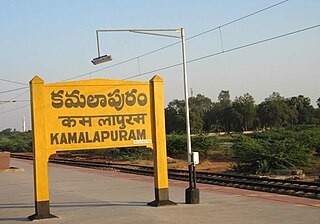
Kamalapuram is a Town and Nagara Panchayat in YSR Kadapa district of the Indian state of Andhra Pradesh. It is located in Kamalapuram mandal of Kadapa revenue division and is the Thaluka headquarter of Kamalapuram assembly constituency.
Singur is a community development block that forms an administrative division in Chandannagore subdivision of Hooghly district in the Indian state of West Bengal.
Tarakeshwar is a panchayat samiti in Chandannagore subdivision of Hooghly district in the Indian state of West Bengal.
Nallamothu Bhaskar Rao is an Indian politician representing the Miryalaguda constituency, Telangana. Though he won as a Congress candidate in 2014, and he again won as a TRS candidate in 2018. He is a native of Shakapuram village, Nidamanoor Mandal of Nalgonda District.
Kamalapuram mandal is one of the 50 mandals in Kadapa district of the Indian state of Andhra Pradesh. It is under the administration of Kadapa revenue division and the headquarters are located at Kamalapuram. The mandal is bounded by Yerraguntla, Proddutur, Chapad, Khajipet, Vallur, Pendlimarri and Veerapunayunipalle mandals.

Jonnalagadda is a village in Guntur district of the Indian state of Andhra Pradesh. It is located in Guntur East mandal of Guntur revenue division. It is 13 km away from Guntur. Due to its proximity to the town the village boasts of many educated people. This Jonnalagadda is between Lam and Venigandla village is different village not to be confused with one near Narasarao pet. Jonnalagadda is a perfect village with soils suitable to grow rice, cotton, chillis, and rainfed crops, and dairy, several temples and churches, 3 Kalyana Mandapams, 2 elementary schools and 1 beautiful High School with 7 acres built and donated by Sri Thalla Appi Reddy/Sri Gudibandla Sambi Reddy funded by Mr.Venkata Reddy/Asha Thalla(NRI). Mr.Venkata Reddy Thalla researched deep into root causes of the problems faced by village and wrote BalaRama Krishna Pandava Rajyanga foundation model upgrading from the current worldwide outdated model. Jonnalagadda has Veterinary hospital built by Sri Thalla Appi Reddy garu funded by his son Mr.Venkata Reddy Thalla who nominated a committee of 6 village leaders on the site donated by Sri Alla Bucchi Reddy garu ex Sarpanch of the village. There are many temples and churches in the village i.e. Sai baba temple,3 Vinayaka temples, Anjaneya gudi, oldest Sivalayam, Brahmmam gari gudi, 3 Ramalayams and Vinayaka gudi at bus stand and in Chalama Reddi Palem, 1 elementary school in Chalama Reddy Palem, 1 elementary school in east side, 1 elementary school in westside SC colony, 2 Poleramma temples and Boddurai near Gandhi bomma where prayers are offered on special occasions. Sankranthi festival is celebrated by conducting sports, games and sometimes yedla pandalu, in which many people from nearby villages also take part and enjoy. Every festival is celebrated with pomp and show. Major festivals are Vinayaka chavithi, Sri Rama Navami and Dasara. For Vinayaka Chaviti, children enjoy identifying and collecting herbs for puja, preparing Ganesh idols with clay, performing puja and immersing the God in village lake. Occasionally, Poleramma jataras are performed. Jonnalagadda stands as an example for communal amity with 6 churches. Christmas is celebrated with equal fervor. Jonnalagadda has a satellite village, Chalama Reddy Palem and nearby TatiReddy Palem which is part of LAM village.
Beeda Masthan Rao Yadav is an Indian politician and businessman. He was Member of Legislative Assembly from Kavali Constituency, Andhra Pradesh. He was elected to the Rajya Sabha in 2022.
