Duisburg Inner Harbour

Last updated
Duisburg Inner Harbour
Duisburg harbour old.jpg
Duisburg Inner Harbor around 1900
Duisburg Inner Harbour
Click on the map for a fullscreen view
Location
Country Germany
Location Duisburg
Coordinates 51°26′27″N6°45′58″E / 51.44083°N 6.76611°E / 51.44083; 6.76611
Details
Type of harbour Harbour
JoinsRhine River
Statistics
Website
www.duisport.de
Warehouses of the Kuppersmuhle and Werhahnmuhle Innenhafen Duisburg Werhahmuhle Kuppersmuhle Blaue Stunde 2014.jpg
Warehouses of the Küppersmühle and Werhahnmühle
Museum Kuppersmuhle in the Inner Harbor Duisburg museum kuppersmuhle sammlg grothe vertikal.jpg
Museum Küppersmühle in the Inner Harbor
Dragon Boat-Regatta during the Inner Harbor Festival 2005 Drachenbootregatta.jpg
Dragon Boat-Regatta during the Inner Harbor Festival 2005
Plan of the Development Innenhafen Duisburg Plan RundgangAlsErlebnis.jpg
Plan of the Development

The Innenhafen (Inner Harbour) in Duisburg, Germany, is connected to the Rhine River, encompasses an area of 89 hectares (220 acres). For over a hundred years during the high point of the Industrial Revolution, it was the central harbour and trading point of the town. Since the mid-1960s, the importance of the harbour declined and it lay in a disused condition for 20 years, before plans for renovation were drawn up. This former industrial area has been fundamentally transformed, a process which started as a part of the International Building Exhibition Emscher Park (IBA) which ran from 1989 until 1999.

Contents

The basis for this model of development in the Ruhr district was delivered in 1994 by the British architect Norman Foster. Since then, the Inner Harbor has transformed itself into a district combining employment, housing, culture and water-based leisure activities. Today, the Inner Harbour is both industrial heritage and a main stop on the Route der Industriekultur. [1]

History

Where the Inne Harbour is today, the Rhine flowed many centuries ago. Up until the 5th century, the boundary of the Roman Empire ran through this locality. During the Middle Ages a Frankish regal court was built on the banks of the Rhine, today that place is occupied by the Rathaus. In the same area were to be found the old Duisburg town church, the Saviour Church  [ de ], the market hall and the city walls.

According to recent research, around the year 1000 the Rhine shifted its course westwards. Duisburg found itself no longer lying directly on the Rhine; it remained connected to the river only through a "dead" arm of the Rhine for the following 400 years. As a result, this previously important trading town declined into a small agricultural settlement. It was only in the 19th century that an initiative to resurrect the connection to the Rhine proved successful. Initially, the Outer Harbour was dug from the Rhine in the west as far as the contemporary Marientor Bridge, to which an eastern extension was later built, the Inner Harbour. Early on, the timber industry established itself on the harbour, mining interest being a major customer for their products then, as modern production methods were able to reduce their space requirements, grain mills began to establish themselves in several locations, along with their warehouses for storage. They conferred on the Inner Harbour the nickname "bread basket of the Ruhr district", supplying the rapidly growing population in the district.

After the decline of the grain mills in the 1960s, the Inner Harbour lost its economic significance and was characterized primarily by warehousing. Nevertheless, the district still continued to block off access to the water from the city itself. The first steps in giving the inner harbour a new face were taken at the end of the 1980s with the opening up of city walls and the construction of a new living quarter on Corputiusplatz.

Within the framework of the IBA Emscher Park, which renovated the industrial areas of the Ruhr in an exemplary fashion, a transformation design for the entire Inner Harbour was launched. The water was to be reincorporated into the city, it was to be made freely accessible and produce an enhanced quality of living – and attract investors. Space for employment – especially in the service sector – for living, culture and leisure were to be integrated into the overall plan. In this sense, the industrial and historic "symbols" of the harbour were to be quite consciously retained.

The Inner Harbour today

Highlights of the newly renovated quarter of the Inner Harbour are the Küppersmühle converted to an arts museum by Herzog & de Meuron, the Werhahnmühle, which following the departure of the Children's Museum ATLANTIS was used as a "Legoland Discovery Centre", [2] the Cultural- and City History Museum, the "Garden of Remembrance" laid out by Dani Karavan as well as the Synagoge of the Jewish District of Duisburg-Mülheim/Ruhr-Oberhausen, designed by the architect Zvi Hecker.

Additionally, on the far side of the Garden a marina has been built complete with a Buckelbrücke ('Buckle bridge' – for pedestrians). It is intended to extend the marina into the adjacent Holzhafen.

A lively dining-scene has also developed. In addition to more than 15 restaurants and clubs, there are also owner-run bars and franchises.

Progression of Developments

After a previous project had run into problems revolving around the awarding of the contract, 2008 should see an investor beginning the construction of Eurogate, a semi-elliptical multi-functional building with up to 10 floors and a floor area of about 35,000 m2 (380,000 sq ft). The design for this building, by Foster, follows the curvature of the Holzhafen. Works for reclamation of land on the bank hit the news when a crane overturned and burnt-out.

Foster has – under contract from the City Council – come up with a new master plan, for the western part of the Inner Harbour, bordering directly onto the Altstadt. This master plan foresees a transformation similar to that which has been carried out in the eastern section – which is itself still ongoing: A further area for a new building lies at the further end, near to the Küppersmühle. The Museum Küppersmühle has extension plans, following the need for more space due to the fusion of the Grothe und Ströher collections. Behind of the office building on the Northern bank, a park is envisaged. In order to coordinate the ideas of the planners regarding the Inner Harbour and the City Centre, the Innenhafen-Entwicklungsgesellschaft (Inner Harbour Development Society) will additionally manage the renovation of the entire City Centre.

As from 2010 the Land Archive of NRW will be based in the Upper Harbour. Up until now it has been based in Düsseldorf (Main Archive) and Brühl (Personenstandsarchiv Brühl). In December 2007 the Austrian architects Ortner und Ortner received the commission for converting a listed storage building from the 1930s.

Views

Pictures

Panorama

Duisburg Innenhafen Ludwigturm.jpg
View of the Marina (left hand) and the "Five Boats" office complex, designed by the British architect Nicholas Grimshaw. On the right hand you can see the Holzhafen, which will be encircled by a projected hotel complex called Eurogate. The free space shown in the photograph to the left of Grimshaw's 'boat building' does not actually exist any more (used for the "Hitachi Power Office").

Related Research Articles

<span class="mw-page-title-main">Ruhr</span> Urban area in North Rhine-Westphalia, Germany

The Ruhr, also referred to as the Ruhr area, sometimes Ruhr district, Ruhr region, or Ruhr valley, is a polycentric urban area in North Rhine-Westphalia, Germany. With a population density of 2,800/km2 and a population of over 5 million (2017), it is the largest urban area in Germany. It consists of several large cities bordered by the rivers Ruhr to the south, Rhine to the west, and Lippe to the north. In the southwest it borders the Bergisches Land. It is considered part of the larger Rhine-Ruhr metropolitan region of more than 10 million people, which is the third largest in Western Europe, behind only London and Paris.

<span class="mw-page-title-main">Duisburg</span> City in North Rhine-Westphalia, Germany

Duisburg is a city in the Ruhr metropolitan area of the western German state of North Rhine-Westphalia. Lying on the confluence of the Rhine and the Ruhr rivers in the center of the Rhine-Ruhr Region, Duisburg is the 5th largest city in North Rhine-Westphalia and the 15th-largest city in Germany.

<span class="mw-page-title-main">Oberhausen</span> City in North Rhine-Westphalia, Germany

Oberhausen is a city on the river Emscher in the Ruhr Area, Germany, located between Duisburg and Essen. The city hosts the International Short Film Festival Oberhausen and its Gasometer Oberhausen is an anchor point of the European Route of Industrial Heritage.

<span class="mw-page-title-main">Rhine–Herne Canal</span> Transportation canal in Germany

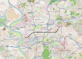
The Rhine–Herne Canal is a 45.6-kilometre-long (28.3 mi) transportation canal in the Ruhr area of North Rhine-Westphalia, Germany, with five canal locks. The canal was built over a period of eight years and connects the harbour in Duisburg on the Rhine with the Dortmund-Ems Canal near Henrichenburg, following the valley of the Emscher. It was widened in the 1980s. The Rhein-Herne canal ship was designed specifically for this canal; normally of about 1300–1350 ton capacity, it has a maximum draft of 2.50 metres (8.2 ft), a length of approximately 80 metres (260 ft), and maximum beam of 9.50 metres (31.2 ft).

Duisburg Hauptbahnhof is a railway station in the city of Duisburg in western Germany. It is situated at the meeting point of many important national and international railway lines in the Northwestern Ruhr valley.

<span class="mw-page-title-main">Oberhausen Hauptbahnhof</span> Railway station in North Rhine-Westphalia, Germany

Oberhausen Hauptbahnhof is a railway station in Oberhausen, North Rhine-Westphalia, Germany. The station was opened in 1847 and is located on the Duisburg–Dortmund railway, Arnhem-Oberhausen railway, Oberhausen–Duisburg-Ruhrort railway and Oberhausen-Mülheim-Styrum railway and is served by ICE, IC, RE and RB services operated by Deutsche Bahn, Abellio Deutschland, NordWestBahn and Eurobahn.

<span class="mw-page-title-main">Industrial Heritage Trail</span> Network of tourist attractions in and around the Ruhr Area, Germany

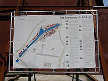
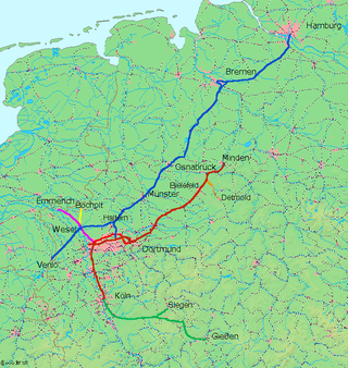
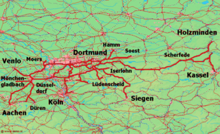
The Industrial Heritage Trail links tourist attractions related to the industrial heritage in the Ruhr area in Germany. It is a part of the European Route of Industrial Heritage. The series of routes were developed between 1989 and 1999, however additions are still being made.

<span class="mw-page-title-main">Cologne–Duisburg railway</span> Railway line

The 64 km long Cologne–Duisburg railway is one of the most important lines in Germany. It is the main axis for long distance and urban passenger rail services between Cologne and the Ruhr, served by Intercity Express, Intercity, Regional Express, regionalbahn and S-Bahn trains. It was the first section built of the Cologne-Minden trunk line and is one of the oldest railways in Germany. It was opened in 1845/46 and has been repeatedly modernized and expanded. Today the route comprises two or three double lines and is electrified throughout.

<span class="mw-page-title-main">Witten/Dortmund–Oberhausen/Duisburg railway</span> Railway in Germany

The Witten/Dortmund, Oberhausen/Duisburg railway is one of the most important railways in Germany. It is the main axis of long distance and regional rail transport on the east–west axis of the Ruhr and is served by Intercity-Express, InterCity, Regional-Express, Regionalbahn and S-Bahn trains.

<span class="mw-page-title-main">Museum Küppersmühle</span> Museum in Germany

Museum Küppersmühle (MKM) is a Centre for Modern and Contemporary Art based in Duisburg's Inner Harbour. It houses the Ströher Collection. It is part of the Duisburg: Town and Harbour section of the Ruhr Industrial Heritage Trail.

<span class="mw-page-title-main">History of the Ruhr</span> Aspect of history

The actual boundaries of the Ruhr vary slightly depending on the source, but a good working definition is to define the Lippe and Ruhr as its northern and southern boundaries respectively, the Rhine as its western boundary, and the town of Hamm as the eastern limit.

<span class="mw-page-title-main">Oberhausen–Duisburg-Ruhrort railway</span>

The Oberhausen–Duisburg-Ruhrort railway is a line in the German state of North Rhine-Westphalia. It runs from Oberhausen via Duisburg-Meiderich to Duisburg-Ruhrort.

<span class="mw-page-title-main">Essen West station</span> Railway station in Essen, Germany

Essen West station is situated in Essen on the Witten/Dortmund–Oberhausen/Duisburg railway in the German state of North Rhine-Westphalia. It is served by lines S1, S3 and S9 of the Rhine-Ruhr S-Bahn.

<span class="mw-page-title-main">Mülheim-Styrum station</span>

Mülheim-Styrum station is located in the district of Styrum in the German city of Mülheim in the German state of North Rhine-Westphalia. It is on the Witten/Dortmund–Oberhausen/Duisburg line and is classified by Deutsche Bahn as a category 3 station.

<span class="mw-page-title-main">Essen-Steele Ost station</span> Railway station in Essen, Germany

Essen-Steele Ost station is located in the district of Essen-Steele in the German city of Essen in the German state of North Rhine-Westphalia. It is on the Witten/Dortmund–Oberhausen/Duisburg line and is classified by Deutsche Bahn as a category 4 station. It is served by Rhine-Ruhr S-Bahn lines S 1 and S 3.

The Mülheim-Heißen–Oberhausen-Osterfeld Nord railway is a line that formerly ran continuously in the western Ruhr region from Heißen to Osterfeld in the German state of North Rhine-Westphalia.

The Bochum–Essen/Oberhausen railway was built by the Bergisch-Märkische Railway Company to the north of its main line through the central Ruhr to tap traffic from mines and factories in the northern Ruhr region, which is now in the German state of North Rhine-Westphalia.

<span class="mw-page-title-main">Emschergenossenschaft</span>

The Emschergenossenschaft is the oldest and biggest public German water board, („Wasserwirtschaftsverband”) located in Essen and responsible for the 865 km2 Emscher catchment with 2.2 million citizens. The main tasks are wastewater discharge and treatment, flood protection, groundwater management, settlement of claims caused by hard coal mining, river restoration and protection of ecosystems.

The Internationale Bauausstellung Emscher Park or International Architecture Exhibition Emscher Park was a programme for structural changes in the so-called German Ruhr region from 1989 to 1999 in order to show new concepts in terms of social, cultural and ecologic ideas.

References

  1. Walter, Guntram (2018-03-15). "Route-Industriekultur". www.route-industriekultur.de (in German). Retrieved 2018-03-23.
  2. "LEGOLAND Discovery Centre Duisburg – Offizielle Webseite - Bestpreisgarantie". Archived from the original on 2012-02-24. Retrieved 2012-02-23.