Duncow

Last updated
Duncow
Duncow windmill.jpg
The ruined windmill above the village.
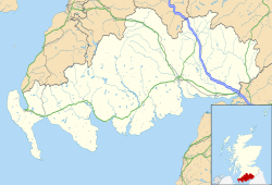
Dumfries and Galloway UK location map.svg
Red pog.svg
Duncow
Location within Dumfries and Galloway
OS grid reference NX965833
Council area
Lieutenancy area
Country Scotland
Sovereign state United Kingdom
Post town DUMFRIES
Postcode district DG1
Police Scotland
Fire Scottish
Ambulance Scottish
UK Parliament
Scottish Parliament
List of places
UK
Scotland
55°08′04″N3°37′20″W / 55.13444°N 3.62222°W / 55.13444; -3.62222 Coordinates: 55°08′04″N3°37′20″W / 55.13444°N 3.62222°W / 55.13444; -3.62222

Duncow is a small settlement in the civil parish of Kirkmahoe, Dumfries and Galloway, Scotland. Located in the geographical centre of the parish, [1] Duncow was a village in the eighteenth and nineteenth centuries [2] and was formerly its most populous settlement. At the time the First Statistical Account of Scotland was written the village had between 150 and 200 residents. [1] By the time of the Third Statistical Account there were only five houses in the village. [1] It has had a school since at least the time of the New Statistical Account. The current school was opened in 1878 and has a roll of 24. [3] The village post office closed in 1952. [1]

The name Duncow, recorded as Duncol in 1250, [4] is of Celtic origin, representing either Cumbric dīn + coll [5] or Gaelic dùn-choll, [5] both meaning 'fort of hazels'. [6]
Related Research Articles

Dumfries and Galloway Council area of Scotland

Dumfries and Galloway is one of 32 unitary council areas of Scotland and is located in the western Southern Uplands. It comprises the historic counties of Dumfriesshire, Kirkcudbrightshire, and Wigtownshire, the latter two of which are collectively known as Galloway. The administrative centre is the town of Dumfries.

Kirkcudbrightshire Historic county in Scotland

Kirkcudbrightshire, or the County of Kirkcudbright or the Stewartry of Kirkcudbright, is a historic county, registration county and lieutenancy area in the informal Galloway area of south-western Scotland. For local government purposes, it forms part of the wider Dumfries and Galloway council area of which it forms a committee area under the name of the Stewartry.

Dalbeattie Human settlement in Scotland

Dalbeattie is a town in the historical county of Kirkcudbrightshire in Dumfries and Galloway, Scotland. Dalbeattie is in a wooded valley on the Urr Water 4 miles (6 km) east of Castle Douglas and 12 miles (19 km) south west of Dumfries. The town is famed for its granite industry and for being the home town of William McMaster Murdoch, the First Officer of the RMS Titanic.

Dumfriesshire, Clydesdale and Tweeddale (UK Parliament constituency) Parliamentary constituency in the United Kingdom, 2005 onwards

Dumfriesshire, Clydesdale and Tweeddale is a constituency of the House of Commons, located in the South of Scotland, within the Dumfries and Galloway, South Lanarkshire and Scottish Borders council areas. It elects one Member of Parliament (MP) at least once every five years using the First-past-the-post system of voting. It is currently represented in Westminster by the former Secretary of State for Scotland, David Mundell, a Conservative, who has been the MP since 2005.

Penpont Human settlement in Scotland

Penpont is a village about 2 miles (3 km) west of Thornhill in Dumfriesshire, in the Dumfries and Galloway region of Scotland. It is near the confluence of the Shinnel Water and Scaur Water rivers in the foothills of the Southern Uplands. It has a population of about 400 people.

Terregles Human settlement in Scotland

Terregles is a village and civil parish near Dumfries, in Dumfries and Galloway, Scotland. It lies in the former county of Kirkcudbrightshire.

Dornock Human settlement in Scotland

Dornock is a small Scottish village in Dumfries and Galloway, situated about 1 mile (1.6 km) west of Eastriggs and 2 miles (3 km) east of Annan. Dornock is built on land which is 10 to 20 metres above sea level. Dornock Burn runs east of the village and the railway between Annan and Gretna is north of the village. The mud and sand banks of the Solway Firth are less than one mile away to the south.

Newton Wamphray Human settlement in Scotland

Newton Wamphray is a village in Dumfries and Galloway. Wamphray is the name of the surrounding parish and of the Wamphray Water, which flows south-west through the Wamphray Glen to join the River Annan near the small village, or hamlet, of Newton.

Cummertrees Human settlement in Scotland

Cummertrees is a coastal village and civil parish of Annandale in the historical county of Dumfriesshire in Dumfries and Galloway. It lies about 1 mile (1.6 km) inland, on the Pow Water to the northwest of Powfoot, 12 miles (19 km) from Dumfries and 3 miles (5 km) from Annan.

Criffel

Criffel is a hill in the historical county of Kirkcudbrightshire, Dumfries and Galloway, south-west Scotland. It is 570 m (1,870 ft) high but appears higher because of its great isolation and high prominence. It is a prominent feature in many of the views from the northern Lake District on a clear day. It is surrounded by a host of satellites, including Long Fell, Maidenpap and Bainloch Hill. The slopes of Criffel feature the upland vegetation of heather, bog cotton and blaeberry and are inhabited by skylarks. Loch Kindar sits at the foot of the hill. A new path to the summit is currently finishing construction.

Durisdeer Human settlement in Scotland

Durisdeer is a small village in Dumfries and Galloway, south-west Scotland. It lies 6 miles (9.7 km) north of Thornhill, above the Carron Water, a tributary of the Nith.

Cargenbridge Human settlement in Scotland

Cargenbridge is a village located in Dumfries and Galloway, United Kingdom southwest of Dumfries. It is in Troqueer parish, in the historic county of Kirkcudbrightshire.

Dunscore Human settlement in Scotland

Dunscore is a small village which lies 9 miles (14 km) northwest of Dumfries on the B729, in Dumfriesshire, in the District Council Region of Dumfries and Galloway, southwest Scotland.

Tynron is a village and civil parish in Dumfries and Galloway, south-west Scotland, lying in a hollow of the Shinnel Water, 2 miles (3.2 km) from Moniaive.

Closeburn, Dumfries and Galloway Village in rural lowland Scotland

Closeburn is a village and civil parish in Dumfries and Galloway, Scotland. The village is on the A76 road 2+12 miles (4 km) south of Thornhill. In the 2001 census, Closeburn had a population of 1,119. Closeburn is recorded as Killosbern in 1185. The first element of the name is Gaelic cill 'cell or church'. The second element is a saint's name, but none has definitely been identified.

Twelve Apostles Stone Circle Stone circle in Dumfries and Galloway, Scotland

The Twelve Apostles is a large stone circle located between the villages of Holywood and Newbridge, near Dumfries, Scotland. It is the seventh largest stone circle in Britain and the largest on the mainland of Scotland. It is similar in design to the stone circles of Cumbria, and is considered to be an outlier of this group. Its south-westerly arrangement aligns it with the midwinder sunset.

Troqueer Human settlement in Scotland

Troqueer is a former village and a parish in the historic county of Kirkcudbrightshire in Dumfries and Galloway on the west side of the River Nith. The eastern-side was merged with Dumfries to the east in 1929, and today eastern Troqueer is a suburb of Dumfries.

Kirkmahoe is a civil parish in Dumfries and Galloway. The parish contains the settlements Kirkton, where the parish church is located, Dalswinton and Duncow. It is bounded by the parishes of Dumfries to the south, Holywood and Dunscore to the west, and Kirkmichael and Tinwald to the east.

Holywood, Dumfries and Galloway Human settlement in Scotland

Holywood is a village and civil parish in the historical county of Dumfriesshire in Dumfries and Galloway, Scotland. The village of Holywood was developed in the mid twentieth century. In 1949 eighteen houses were built by the county council and followed shortly after by another 38.

Kirkgunzeon Human settlement in Scotland

Kirkgunzeon is a village and civil parish in Dumfries and Galloway, south west Scotland. The village is 10.4 miles (16.7 km) south west of Dumfries and 4.1 miles (6.6 km) north east of Dalbeattie. The civil parish is in the former county of Kirkcudbrightshire, and is bounded by the parishes Lochrutton to the north, Urr to the west, Colvend and Southwick to the south and New Abbey to the east.

References

  1. 1 2 3 4 Duncan, Walter (1962). "Chapter 12: The Parish of Kirkmahoe". In Houston, George (ed.). The County of Dumfries. The Third Statistical Account of Scotland. Glasgow: Collins. p. 142.
  2. Gifford, John (2002) [1996]. Dumfries and Galloway. Pevsner Architectural Guides: The Buildings of Scotland. New Haven and London: Yale University Press. p. 284. ISBN   9780300096712.
  3. "Duncow Primary School". Dumfries and Galloway Council. Archived from the original on 2016-01-30. Retrieved 2015-05-15.
  4. Johnson-Ferguson, Edward (1935). The Place-Names of Dumfriesshire. Dumfries: Courier Press. p. 73.
  5. 1 2 James, Alan G. (2014). The Brittonic Language in the Old North: A Guide to the Place-Name Evidence (PDF). Vol. 2: Guide to the Elements. p. 108,144. Archived from the original (PDF) on 2014-09-11.
  6. Watson, William J. (1925). "The Celts (British and Gael) in Dumfriesshire and Galloway" (PDF). Transactions and Journal of Proceedings of the Dumfriesshire and Galloway Natural History and Antiquarian Society. Third Series. XI: 143. Archived from the original (PDF) on 2014-08-31.