Dycusburg, Kentucky

Last updated
Dycusburg, Kentucky
Nickname: 
“Folding chair capital of the world”
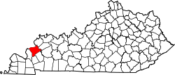
Crittenden County Kentucky Incorporated and Unincorporated areas Dycusburg Highlighted 2123140.svg
Location of Dycusburg, in Crittenden County, Kentucky
Coordinates: 37°9′36″N88°11′6″W / 37.16000°N 88.18500°W / 37.16000; -88.18500 Coordinates: 37°9′36″N88°11′6″W / 37.16000°N 88.18500°W / 37.16000; -88.18500
Country United States
State Kentucky
County Crittenden
Area
  Total0.04 sq mi (0.1 km2)
  Land0.04 sq mi (0.1 km2)
  Water0.0 sq mi (0.0 km2)
Elevation
374 ft (114 m)
Population
 (2010)
  Total26
  Density675/sq mi (260.7/km2)
Time zone UTC-6 (Central (CST))
  Summer (DST) UTC-5 (CDT)
ZIP code
42037
Area code(s) 270 & 364
FIPS code 21-23140
GNIS feature ID0491380

Dycusburg is an unincorporated community in Crittenden County, Kentucky, United States. The population was 26 at the 2010 census. [1]

Contents

Geography

Dycusburg is located near the southern tip of Crittenden County at 37°9′36″N88°11′6″W / 37.16000°N 88.18500°W / 37.16000; -88.18500 (37.160017, -88.184952), [2] on the east bank of the Cumberland River. It is 10 miles (16 km) north of Lake Barkley, the reservoir on the Cumberland River that forms part of the Land Between the Lakes National Recreation Area, and 10 miles (16 km) east by air (25 miles (40 km) by road) of Smithland, Kentucky, where the Cumberland River joins the Ohio. Dycusburg is the site of a former ferry across the Cumberland River, which closed in 1951. [3] According to the United States Census Bureau, the city has a total area of 0.04 square miles (0.10 km2), all land. [1]

History

The town of Dycusburg was laid out by William E. Dycus [4] and became a shipping port on the Cumberland River. A post office was established in 1848. [5] On February 4, 1908, during the Tobacco Wars, the Night Riders occupied the city and burned the Bennett Brothers' tobacco warehouse and distillery. [6] The city was disincorporated in 1980. [7]

Demographics

As of the census [8] of 2000, there were 39 people, 18 households, and 10 families residing in the city. The population density was 889.7 inhabitants per square mile (343.5/km2). There were 20 housing units at an average density of 456.3 per square mile (176.2/km2). The racial makeup of the city was 97.44% White, and 2.56% from two or more races.

There were 18 households, out of which 22.2% had children under the age of 18 living with them, 50.0% were married couples living together, 5.6% had a female householder with no husband present, and 44.4% were non-families. 38.9% of all households were made up of individuals, and 16.7% had someone living alone who was 65 years of age or older. The average household size was 2.17 and the average family size was 3.00.

In the city, the population was spread out, with 20.5% under the age of 18, 7.7% from 18 to 24, 20.5% from 25 to 44, 25.6% from 45 to 64, and 25.6% who were 65 years of age or older. The median age was 46 years. For every 100 females, there were 129.4 males. For every 100 females age 18 and over, there were 121.4 males.

The median income for a household in the city was $45,208, and the median income for a family was $46,250. Males had a median income of $46,250 versus $0 for females. The per capita income for the city was $15,253. None of the population and none of the families were below the poverty line.

Schools

Students in Dycusburg attend Crittenden County Schools located in Marion.

Related Research Articles

<span class="mw-page-title-main">Lyon County, Kentucky</span> County in Kentucky, United States

Lyon County is a county located in the U.S. state of Kentucky. As of the 2020 census, the population was 8,680. Its county seat is Eddyville. The county was formed from Caldwell County, Kentucky in 1854 and named for former Congressman Chittenden Lyon.

<span class="mw-page-title-main">Livingston County, Kentucky</span> County in Kentucky, United States

Livingston County is a county located in the U.S. state of Kentucky. As of the 2020 census, the population was 8,888. Its county seat is Smithland. The county was established in 1798 from land taken from Christian County and is named for Robert R. Livingston, a member of the Committee of Five that drafted the U.S. Declaration of Independence. The county was strongly pro-Confederate during the American Civil War and many men volunteered for the Confederate Army.

<span class="mw-page-title-main">Rhodes, Iowa</span> City in Iowa, United States

Rhodes is a city in Marshall County, Iowa, United States. The population was 271 at the time of the 2020 census.

<span class="mw-page-title-main">Bardwell, Kentucky</span> City in Kentucky, United States

Bardwell is a home rule-class city in and the county seat of Carlisle County, Kentucky, United States. The city was formally incorporated by the state assembly in 1878. The population was 714 at the 2020 census, down from 723 in 2010.

<span class="mw-page-title-main">Marion, Kentucky</span> City in Kentucky, United States

Marion is a home rule-class city in Crittenden County, Kentucky, in the United States. It is the seat of its county. As of the 2010 census, the city population was 3,039.

<span class="mw-page-title-main">Burkesville, Kentucky</span> City in Kentucky, United States

Burkesville is a home rule-class city in Cumberland County, Kentucky, in the United States. Nestled among the rolling foothills of Appalachia and bordered by the Cumberland River to the south and east, it is the seat of its county. The population was 1,521 at the 2010 census.

<span class="mw-page-title-main">Crittenden, Kentucky</span> City in Kentucky, United States

Crittenden is a home rule-class city in Grant and Kenton counties, Kentucky, in the United States. The population was 3,815 as of the 2010 census, up from 2,401 at the 2000 census.

<span class="mw-page-title-main">Benham, Kentucky</span> City in Kentucky, United States

Benham is a home rule-class city in Harlan County, Kentucky, in the United States. The city was formally incorporated by the General Assembly in 1961. The population was 500 at the 2010 census and estimated in 2018 to be 434.

<span class="mw-page-title-main">Cumberland, Kentucky</span> City in Kentucky, United States

Cumberland is a home rule-class city in Harlan County, Kentucky, in the United States. The population according to the 2010 Census was 2,237, down from 2,611 at the 2000 census.

<span class="mw-page-title-main">Loyall, Kentucky</span> City in Kentucky, United States

Loyall is a home rule-class city in Harlan County, Kentucky, in the United States. The population was 1,461 as of the 2010 census, up from 766 at the time of the 2000 census.

<span class="mw-page-title-main">Wallins Creek, Kentucky</span> Census-designated place in Kentucky, United States

Wallins Creek is an unincorporated community and census-designated place (CDP) in Harlan County, Kentucky, United States. The population was 156 at the 2010 census, when it was still a city, having dropped from 257 at the 2000 census.

<span class="mw-page-title-main">Goose Creek, Kentucky</span> City in Kentucky, United States

Goose Creek is a home rule-class city in Jefferson County, Kentucky, United States. The population was 294 at the 2010 census.

<span class="mw-page-title-main">Carrsville, Kentucky</span> City in Kentucky, United States

Carrsville is a home rule-class city beside the Ohio River in Livingston County, Kentucky, in the United States. The population was 50 at the 2010 census, declining from 64 as of 2000. It is part of the Paducah, KY-IL Micropolitan Statistical Area. It is situated just west of the junction of where Buck Creek empties into the Ohio River.

<span class="mw-page-title-main">Grand Rivers, Kentucky</span> City in Kentucky, United States

Grand Rivers is a home rule-class city in Livingston County, Kentucky, in the United States. The population was 382 at the 2010 census, up from 343 in 2000. It is part of the Paducah micropolitan area.

<span class="mw-page-title-main">Salem, Kentucky</span> City in Kentucky, United States

Salem is a home rule-class city in Livingston County, Kentucky, in the United States. Salem is part of the Paducah micropolitan area. The population was 752 during the 2010 census, down from 769 in 2000. It the largest city in Livingston County, although the census-designated place of Ledbetter has more than twice the population of Salem.

<span class="mw-page-title-main">Eddyville, Kentucky</span> City in Kentucky, United States

Eddyville is a home rule-class city in and the county seat of Lyon County, Kentucky, United States. The population was 2,554 at the 2010 census, up from 2,350 in 2000. The Kentucky State Penitentiary is located at Eddyville. The town is considered a tourist attraction because of its access to nearby Lake Barkley.

<span class="mw-page-title-main">Kuttawa, Kentucky</span> City in Kentucky, United States

Kuttawa is a home rule-class city in Lyon County, Kentucky, in the United States. The population was 649 as of the 2010 census, up from 596 in 2000.

<span class="mw-page-title-main">Ferguson, Kentucky</span> City in Kentucky, United States

Ferguson is a home rule-class city just south of downtown Somerset in Pulaski County, Kentucky, United States. It had a population of 924 as of the 2010 census, up from 881 in 2000.

<span class="mw-page-title-main">Russell Springs, Kentucky</span> City in Kentucky, United States

Russell Springs is a home rule-class city in Russell County, Kentucky, in the United States. The city is the gateway to Lake Cumberland, one of the largest man-made lakes in the region, created by Wolf Creek Dam. It is the largest city in the county, having a population of 2,441 during the year 2010 U.S. Census.

<span class="mw-page-title-main">Cumberland City, Tennessee</span> Town in Tennessee, United States

Cumberland City is a town in Stewart County, Tennessee. The population was 311 at the 2010 census. It is part of the Clarksville, TN — Kentucky Metropolitan Statistical Area.

References

  1. 1 2 "Geographic Identifiers: 2010 Demographic Profile Data (G001): Dycusburg city, Kentucky". U.S. Census Bureau, American Factfinder. Archived from the original on February 12, 2020. Retrieved August 13, 2014.
  2. "US Gazetteer files: 2010, 2000, and 1990". United States Census Bureau. 2011-02-12. Retrieved 2011-04-23.
  3. Dycusburg Ferry: Closed in 1951
  4. Gannett, Henry (1905). The Origin of Certain Place Names in the United States. Govt. Print. Off. pp.  112.
  5. Rennick, Robert M. (1987). Kentucky Place Names. University Press of Kentucky. p. 87. ISBN   0813126312 . Retrieved 2013-04-28.
  6. The Country Gentleman Newspaper 1908 p.252.
  7. "Boundary and Annexation Survey (BAS) New Incorporations, Mergers, Consolidations, and Disincorporations".
  8. "U.S. Census website". United States Census Bureau . Retrieved 2008-01-31.