The West Branch of the Dead Diamond River is a 2.7-mile-long (4.3 km) river in northern New Hampshire in the United States. It is a tributary of the Dead Diamond River, located in the Androscoggin River watershed of Maine and New Hampshire.
Pleasant River is a 4.7-mile-long (7.6 km) river in Oxford County, Maine in the United States. It is a tributary of the Androscoggin River, which flows east and south to join the Kennebec River in Merrymeeting Bay near the Atlantic Ocean.
The Middle Branch of the Little Magalloway River is a 4.6-mile-long (7.4 km) river in northern New Hampshire and northwestern Maine in the United States. It is a tributary of the Little Magalloway River, located in the Androscoggin River watershed of Maine and New Hampshire.
The West Branch of the Little Magalloway River is a 5.3-mile-long (8.5 km) river in northern New Hampshire and northwestern Maine in the United States. It is a tributary of the Middle Branch Little Magalloway River, located in the Androscoggin River watershed of Maine and New Hampshire.
The West Branch of the Magalloway River is a 9.3-mile-long (15.0 km) river in northernmost New Hampshire and northwestern Maine in the United States. It is a tributary of the Magalloway River, located in the Androscoggin River watershed of Maine and New Hampshire.
The West Branch of the Mohawk River is a 5.5-mile-long (8.9 km) river in northern New Hampshire in the United States. It is a tributary of the Mohawk River, which flows west to the Connecticut River, which in turn flows south to Long Island Sound, an arm of the Atlantic Ocean.

The North Fork of the East Branch of the Pemigewasset River is a 6.9-mile-long (11.1 km) river located in the White Mountains of New Hampshire in the United States. It is a tributary of the East Branch of the Pemigewasset River, part of the Merrimack River watershed.
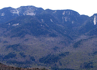
Armstrong Mountain is a mountain located in Essex County, New York, named after Thomas Armstrong, a local pioneer. The mountain is part of the Great Range of the Adirondack Mountains. Armstrong Mtn. is flanked to the southwest by Gothics, and to the northeast by Upper Wolfjaw Mountain.
Doubletop Mountain is a mountain located in Ulster County, New York. The mountain is part of the Catskill Mountains. Doubletop Mountain is flanked to the northwest by Graham Mountain, to the east by Big Indian Mountain, and to the southwest by the Beaver Kill Range.
Lone Mountain is a mountain located in Ulster County, New York. The mountain is part of the Catskill Mountains. Lone Mountain is flanked to the southwest by Table Mountain, and to the east by Rocky Mountain.
The Campbell Branch Little Black River is a short river in Quebec (Canada) and northern Maine.
The East Branch Mattawamkeag River is a tributary of the Mattawamkeag River in Aroostook County, Maine. From its source in Dudley, the river runs 36 miles (58 km) south and southeast to its confluence with the West Branch Mattawamkeag River in Haynesville, about 10 miles (16 km) west of the Canada–United States border.
The East Branch Moose River is a short tributary of the South Branch Moose River in Skinner, Maine. From its source on Kibby Mountain, the river runs 3.1 miles (5.0 km) northwest to its confluence with the Moose River's South Branch.
The East Branch Nezinscot River is a 19.4-mile-long (31.2 km) river in Maine. It flows from its source on Black Mountain in Peru to its confluence with the West Branch in Buckfield. The resulting river, the Nezinscot, continues east to the Androscoggin River, which flows to the Kennebec River near its mouth at the Atlantic Ocean.
The East Branch Piscataquis River is a tributary of the Piscataquis River in Piscataquis County, Maine. From its source in Little Squaw, it runs south 14 miles (23 km) to its confluence with the West Branch Piscataquis River in Blanchard to form the Piscataquis.
The East Branch Pleasant River is a 32.4-mile-long (52.1 km) tributary of the Piscataquis River in Piscataquis County, Maine. From its source in Shawtown, the river runs about 19 miles (31 km) generally southeast to Upper Ebeemee Lake, then about 13 miles (21 km) south through Ebeemee Lake to its confluence with the West Branch to form the Pleasant River in Brownville.
The Middle Branch Pleasant River is a tributary of the Piscataquis River in Piscataquis County, Maine. From the outflow of Middle Branch Pond in Maine Township 5, Range 9, WELS, the river runs 11.4 miles (18.3 km) southeast to its confluence with the East Branch in Brownville. The East Branch runs about 1.5 miles (2.4 km) further south, joining with the West Branch to form the main stem of the Pleasant River.
The Passadumkeag River is a river in Maine. From the confluence of its East Branch and West Branch in Maine Township 3, Range 1, NBPP, the river runs 48.2 miles (77.6 km) south and west to its mouth on the Penobscot River in Passadumkeag.
The West Branch Piscataquis River is a 22-mile-long (35 km) tributary of the Piscataquis River in Piscataquis County, Maine. Its source is in East Moxie, Somerset County . The river runs about 6 miles (10 km) east, then 11 miles (18 km) south, then 5 miles (8 km) east to its confluence with the East Branch Piscataquis River in Blanchard to form the Piscataquis.
The East Branch Pockwock Stream is a tributary of the Pocwock River, flowing in Townships T17 R13 Wels and T16 R13 Wels, in the Aroostook County, in North Maine Woods, in Maine, the United States.

