Corsica, Pennsylvania

Last updated
Corsica, Pennsylvania
Main Street in Corsica.jpg
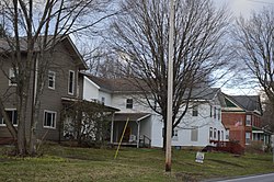
Houses on Main Street
Jefferson County Pennsylvania Incorporated and Unincorporated areas Corsica Highlighted.svg
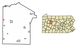
Location of Corsica in Jefferson County, Pennsylvania.
USA Pennsylvania location map.svg
Red pog.svg
Corsica
Usa edcp location map.svg
Red pog.svg
Corsica
Coordinates: 41°10′52″N79°12′08″W / 41.18111°N 79.20222°W / 41.18111; -79.20222
Country United States
State Pennsylvania
County Jefferson
Settled1802
Incorporated1860 [1]
Government
  TypeBorough Council
  MayorDavid Leadbetter
  PresidentCarol Cox
  Vice PresidentAlan Bowley
  SecretaryTammy Laird
Area
[2]
  Total0.45 sq mi (1.17 km2)
  Land0.45 sq mi (1.17 km2)
  Water0.00 sq mi (0.00 km2)
Elevation
1,613 ft (492 m)
Population
 (2020) [3]
  Total319
  Density704.19/sq mi (271.77/km2)
Time zone UTC-5 (Eastern (EST))
  Summer (DST) UTC-4 (EDT)
ZIP code
15829
Area code 814
FIPS code 42-16304
Website www.boroughofcorsica.com

Corsica is a borough in Jefferson County, Pennsylvania, United States. The population was 357 at the 2010 census. [4] It was named for the island of Corsica, birthplace of Napoleon Bonaparte. The mayor of the borough is Dave Leadbetter.

Contents

Geography

Corsica is located in western Jefferson County at 41°10′52″N79°12′8″W / 41.18111°N 79.20222°W / 41.18111; -79.20222 (41.181233, -79.202287). [5] Its western border is the Clarion County line.

U.S. Route 322 passes through the center of town as Main Street, and leads east 6 miles (10 km) to Brookville, the Jefferson county seat, and west 10 miles (16 km) to Clarion. Interstate 80 passes just north of the borough limits, with access from Exit 73 (Pennsylvania Route 949). I-80 leads east 27 miles (43 km) to DuBois and west 54 miles (87 km) to Interstate 79 near Mercer. PA 949 leads northeast 8 miles (13 km) to Sigel and south 5 miles (8 km) to Summerville.

According to the United States Census Bureau, the borough of Corsica has a total area of 0.40 square miles (1.04 km2), all land. [4]

History

Corsica suffered a devastating fire in 1873, which destroyed most of the town's businesses and residences.

The first spade of dirt signifying the groundbreaking for Interstate 80 was shoveled on March 19, 1959, near Corsica.

Demographics

Historical population
CensusPop.Note
1860 249
1870 37249.4%
1880 3915.1%
1890 338−13.6%
1900 293−13.3%
1910 3012.7%
1920 35818.9%
1930 3919.2%
1940 48123.0%
1950 421−12.5%
1960 4312.4%
1970 374−13.2%
1980 3811.9%
1990 337−11.5%
2000 3545.0%
2010 3570.8%
2020 319−10.6%
Sources: [6] [7] [8] [3]

As of the census [7] of 2000, there were 354 people, 145 households, and 94 families residing in the borough. The population density was 758.9 inhabitants per square mile (293.0/km2). There were 157 housing units at an average density of 336.6 per square mile (130.0/km2). The racial makeup of the borough was 98.59% White, 0.85% Asian, and 0.56% from two or more races.

There were 145 households, out of which 30.3% had children under the age of 18 living with them, 55.2% were married couples living together, 4.8% had a female householder with no husband present, and 34.5% were non-families. 30.3% of all households were made up of individuals, and 11.7% had someone living alone who was 65 years of age or older. The average household size was 2.44 and the average family size was 3.08.

In the borough the population was spread out, with 26.6% under the age of 18, 11.0% from 18 to 24, 28.0% from 25 to 44, 20.3% from 45 to 64, and 14.1% who were 65 years of age or older. The median age was 34 years. For every 100 females there were 114.5 males. For every 100 females age 18 and over, there were 101.6 males.

The median income for a household in the borough was $30,625, and the median income for a family was $38,438. Males had a median income of $27,813 versus $18,125 for females. The per capita income for the borough was $13,752. About 7.1% of families and 11.0% of the population were below the poverty line, including 8.2% of those under age 18 and 17.8% of those age 65 or over.

Public services

The Clarion-Limestone Area School District provides kindergarten through 12th grade public education for the community. Clarion-Limestone Area School District operates two schools, Clarion-Limestone Jr/Sr High School (7th-12th) and Clarion-Limestone Elementary School (K-6th).

The borough is home to the Corsica Volunteer Fire Department.

Related Research Articles

<span class="mw-page-title-main">South Bethlehem, Pennsylvania</span> Borough in Pennsylvania, United States

South Bethlehem is a borough in Armstrong County, Pennsylvania, United States. The population was 489 at the 2020 census.

<span class="mw-page-title-main">Callensburg, Pennsylvania</span> Borough in Pennsylvania, United States

Callensburg is a borough in Clarion County, Pennsylvania, United States. The population was 207 at the 2010 census.

<span class="mw-page-title-main">Clarion Township, Clarion County, Pennsylvania</span> Township in Pennsylvania, United States

Clarion Township is a township in Clarion County, Pennsylvania, United States. The population was 3,649 at the 2020 census, a decrease from the figure of 4,116 tabulated in 2010, which was, in turn, an increase over the total of 3,273 at the 2000 census.

<span class="mw-page-title-main">Foxburg, Pennsylvania</span> Borough in Pennsylvania, United States

Foxburg is a borough in Clarion County, Pennsylvania, United States. It is located along the east bank of the Allegheny River, about 2 miles (3 km) north of the mouth of the Clarion River. As of the 2020 census it had a population of 181.

<span class="mw-page-title-main">Hawthorn, Pennsylvania</span> Borough in Pennsylvania, United States

Hawthorn is a borough in Clarion County, Pennsylvania, United States. The population was 482 at the 2020 census.

<span class="mw-page-title-main">Knox, Pennsylvania</span> Borough in Pennsylvania, United States

Knox is a borough in Clarion County, Pennsylvania, United States. The population was 1,102 at the 2020 census.

<span class="mw-page-title-main">Knox Township, Clarion County, Pennsylvania</span> Township in Pennsylvania, United States

Knox Township is a township that is located in Clarion County, Pennsylvania, United States. As of the 2020 census, the township population was 993, a decrease from the figure of 1,036 that was tabulated in 2010.

<span class="mw-page-title-main">Limestone Township, Clarion County, Pennsylvania</span> Township in Pennsylvania, United States

Limestone Township is a township that is located in Clarion County, Pennsylvania, United States. The population was 1,870 at the time of the 2020 census, an increase from the figure of 1,858 tabulated in 2010.

<span class="mw-page-title-main">Redbank Township, Clarion County, Pennsylvania</span> Township in Pennsylvania, United States

Redbank Township is a township in Clarion County, Pennsylvania, United States. The population was 1,334 at the 2020 census, a decrease from the figure of 1,370 tabulated in 2010.

<span class="mw-page-title-main">Richland Township, Clarion County, Pennsylvania</span> Township in Pennsylvania, United States

Richland Township is a township in Clarion County, Pennsylvania, United States. The population was 473 at the 2020 census, a decrease from the figure of 494 tabulated in 2010.

<span class="mw-page-title-main">Rimersburg, Pennsylvania</span> Borough in Pennsylvania, United States

Rimersburg is a borough in Clarion County in the U.S. state of Pennsylvania. The population was 945 at the 2020 census.

<span class="mw-page-title-main">Shippenville, Pennsylvania</span> Borough in Pennsylvania, United States

Shippenville is a borough in Clarion County, Pennsylvania, United States. The population was 446 at the 2020 census.

<span class="mw-page-title-main">Sligo, Pennsylvania</span> Borough in Pennsylvania, United States

Sligo is a borough in Clarion County, Pennsylvania, United States. The population was 686 at the 2020 census.

<span class="mw-page-title-main">St. Petersburg, Pennsylvania</span> Borough in Pennsylvania, United States

St. Petersburg is a borough in Clarion County, Pennsylvania, United States. The population was 338 at the 2020 census.

<span class="mw-page-title-main">Strattanville, Pennsylvania</span> Borough in Pennsylvania, United States

Strattanville is a borough in Clarion County, Pennsylvania, United States. The population was 537 at the 2020 census.

<span class="mw-page-title-main">Barnett Township, Jefferson County, Pennsylvania</span> Township in Pennsylvania, United States

Barnett Township is a township in Jefferson County, Pennsylvania, United States. The population was 231 at the 2020 census down from 254 at the 2010 census. It was named for Jefferson County pioneer Joseph Barnett.

<span class="mw-page-title-main">Brookville, Pennsylvania</span> Borough in Pennsylvania, United States

Brookville is a borough in Jefferson County in the U.S. state of Pennsylvania, 80 miles (130 km) northeast of Pittsburgh. As of the 2010 census, the population was 3,933. Founded in 1830, it is the county seat of Jefferson County.

<span class="mw-page-title-main">Summerville, Pennsylvania</span> Borough in Pennsylvania, United States

Summerville is a borough in Jefferson County, Pennsylvania, United States. The population was 528 at the 2010 census.

<span class="mw-page-title-main">Union Township, Jefferson County, Pennsylvania</span> Township in Pennsylvania, United States

Union Township is a township in Jefferson County, Pennsylvania, United States. The population was 845 at the 2020 census. The name was derived from the term applied to the country of the United States.

<span class="mw-page-title-main">Falls Creek, Pennsylvania</span> Borough in Pennsylvania, United States

Falls Creek is a borough located in Jefferson and Clearfield counties in Pennsylvania, United States. The population was 1,036 at the 2020 census. Of this, 994 were in Jefferson County, and 42 were in Clearfield County.

References

  1. McKnight, William James (1917). Historical. J.H. Beers. p. 498.
  2. "ArcGIS REST Services Directory". United States Census Bureau. Retrieved October 12, 2022.
  3. 1 2 "Census Population API". United States Census Bureau. Retrieved Oct 12, 2022.
  4. 1 2 "Geographic Identifiers: 2010 Census Summary File 1 (G001): Corsica borough, Pennsylvania". American Factfinder. U.S. Census Bureau. Archived from the original on February 13, 2020. Retrieved November 7, 2018.
  5. "US Gazetteer files: 2010, 2000, and 1990". United States Census Bureau. 2011-02-12. Retrieved 2011-04-23.
  6. "Census of Population and Housing". U.S. Census Bureau. Retrieved 20 March 2022.
  7. 1 2 "U.S. Census website". United States Census Bureau . Retrieved 2008-01-31.
  8. "Incorporated Places and Minor Civil Divisions Datasets: Subcounty Resident Population Estimates: April 1, 2010 to July 1, 2012". Population Estimates. U.S. Census Bureau. Archived from the original on 11 June 2013. Retrieved 11 December 2013.