Clover Township, Jefferson County, Pennsylvania

Last updated
Clover Township, Pennsylvania
Clover Township along 949.jpg
Countryside between Corsica and Summerville
Map of Jefferson County, Pennsylvania Highlighting Clover Township.PNG
Map of Jefferson County, Pennsylvania Highlighting Clover Township
Map of Pennsylvania highlighting Jefferson County.svg
Map of Jefferson County, Pennsylvania
Country United States
State Pennsylvania
County Jefferson
Settled1812
Incorporated1841
Government
  TypeTownship of the Second Class, having a three member board of Supervisors
Area
[1]
  Total16.12 sq mi (41.75 km2)
  Land15.94 sq mi (41.29 km2)
  Water0.18 sq mi (0.46 km2)
Population
 (2010) [2]
  Total430
  Estimate 
(2022) [2]
424
  Density27/sq mi (10/km2)
Time zone UTC-5 (Eastern (EST))
  Summer (DST) UTC-4 (EDT)
Area code 814
FIPS code 42-065-14408

Clover Township is a township in Jefferson County, Pennsylvania, United States. The population was 430 at the 2020 census, [2] down from 448 at the 2010 census. [3] It was named for Levi G. Clover, Jefferson County prothonotary, in 1841. [4]

Contents

Geography

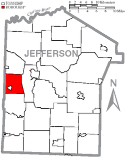
Clover Township is in western Jefferson County and is bordered on its west side by Clarion County. According to the United States Census Bureau, the township has a total area of 16.1 square miles (41.8 km2), of which 15.9 square miles (41.3 km2) are land and 0.2 square miles (0.5 km2), or 1.11%, are water. Redbank Creek, a tributary of the Allegheny River, crosses the township from east to southwest.

The township entirely surrounds the borough of Summerville, located on Redbank Creek. There are two unincorporated villages, Baxter and Content. Pennsylvania Route 28 crosses the township, roughly following Redbank Creek and leading northeast to Brookville, the Jefferson county seat, and southwest to Hawthorn.

Demographics

Historical population
CensusPop.Note
1850 737
1860 91023.5%
1870 868−4.6%
1880 1,05421.4%
1890 642−39.1%
1900 604−5.9%
1910 75024.2%
1920 7895.2%
1930 550−30.3%
1940 540−1.8%
1950 536−0.7%
1960 480−10.4%
1970 448−6.7%
1980 50011.6%
1990 5234.6%
2000 474−9.4%
2010 430−9.3%
2022 (est.)424 [2]
U.S. Decennial Census [5]

As of the census [6] of 2010, there were 448 people, 190 households, and 139 families residing in the township. The population density was 29.3 inhabitants per square mile (11.3/km2). There were 225 housing units at an average density of 13.4/sq.mi (5.2/km2). The racial makeup of the township was 99.3% White, 0.7% from other races Hispanic or Latino of any race were 0.7% of the population.

There were 190 households, out of which 22.6% had children under the age of 18 living with them, 62.1% were married couples living together, 6.8% had a female householder with no husband present, and 26.8% were non-families. 25.8% of all households were made up of individuals, and 10% had someone living alone who was 65 years of age or older. The average household size was 2.36 and the average family size was 2.79.

In the township the population was spread out, with 10.1% under the age of 18, 6.2% from 18 to 24, 10.2% from 25 to 44, 18.6% from 45 to 64, and 8.3% who are 65 years of age or older. The median age was 46.9 years. There were 225 males and 223 females.

The median income for a household in the township was $46,786, and the median income for a family was $59,057. The per capita income for the township was $23,739. About 5.6% of families and 7.5% of the population were below the poverty line, including 12.5% of those under age 18 and 5.9% of those age 65 or over.

Related Research Articles

<span class="mw-page-title-main">Redbank Township, Armstrong County, Pennsylvania</span> Township in Pennsylvania, United States

Redbank Township is a township in Armstrong County, Pennsylvania, United States. The population was 975 at the 2020 census, a decrease from the figure of 1,064 tabulated in 2010.

<span class="mw-page-title-main">South Bethlehem, Pennsylvania</span> Borough in Pennsylvania, United States

South Bethlehem is a borough in Armstrong County, Pennsylvania, United States. The population was 489 at the 2020 census.

<span class="mw-page-title-main">Millcreek Township, Clarion County, Pennsylvania</span> Township in Pennsylvania, United States

Millcreek Township is a township in Clarion County, Pennsylvania, United States. The population was 361 at the 2020 census, a decrease from the figure of 396 tabulated in 2010.

<span class="mw-page-title-main">Porter Township, Clarion County, Pennsylvania</span> Township in Pennsylvania, United States

Porter Township is a township in Clarion County, Pennsylvania, United States. The population was 1,287 at the 2020 census, a decrease from the figure of 1,348 tabulated in 2010.

<span class="mw-page-title-main">Redbank Township, Clarion County, Pennsylvania</span> Township in Pennsylvania, United States

Redbank Township is a township in Clarion County, Pennsylvania, United States. The population was 1,334 at the 2020 census, a decrease from the figure of 1,370 tabulated in 2010.

<span class="mw-page-title-main">Beaver Township, Jefferson County, Pennsylvania</span> Township in Pennsylvania, United States

Beaver Township is a township in Jefferson County, Pennsylvania, United States. The population was 468 at the 2020 census, down from 498 at the 2010 census. It was named for Beaver Run, a stream which traverses the township from east to west.

<span class="mw-page-title-main">Brookville, Pennsylvania</span> Borough in Pennsylvania, United States

Brookville is a borough in Jefferson County in the U.S. state of Pennsylvania, 80 miles (130 km) northeast of Pittsburgh. As of the 2010 census, the population was 3,933. Founded in 1830, it is the county seat of Jefferson County.

<span class="mw-page-title-main">Eldred Township, Jefferson County, Pennsylvania</span> Township in Pennsylvania, United States

Eldred Township is a township in Jefferson County, Pennsylvania, United States. The population was 1,273 at the 2020 census. It was named for Nathaniel B. Eldred, President Judge of the judicial district of which Jefferson County was a part.

<span class="mw-page-title-main">Knox Township, Jefferson County, Pennsylvania</span> Township in Pennsylvania, United States

Knox Township is a township in Jefferson County, Pennsylvania, in the United States. As of the 2020 census, the township population was 1,008. It was named for John C. Knox, then President Judge of the judicial district.

<span class="mw-page-title-main">Oliver Township, Jefferson County, Pennsylvania</span> Township in Pennsylvania, United States

Oliver Township is a township in Jefferson County, Pennsylvania, United States. The population was 1,006 at the 2020 census. It was named after Commodore Oliver Hazard Perry.

<span class="mw-page-title-main">Pine Creek Township, Jefferson County, Pennsylvania</span> Township in Pennsylvania, United States

Pine Creek Township is a township in Jefferson County, Pennsylvania, United States. The population was 1,325 at the 2020 census. The township was named for the abundance of pine trees in the area.

<span class="mw-page-title-main">Ringgold Township, Jefferson County, Pennsylvania</span> Township in Pennsylvania, United States

Ringgold Township is a township in Jefferson County, Pennsylvania, United States. The population was 772 at the 2020 census.

<span class="mw-page-title-main">Rose Township, Jefferson County, Pennsylvania</span> Township in Pennsylvania, United States

Rose Township is a township in Jefferson County, Pennsylvania, United States. The population was 1,157 at the 2020 census. It was named for a prominent citizen named Dr. Rose.

<span class="mw-page-title-main">Summerville, Pennsylvania</span> Borough in Pennsylvania, United States

Summerville is a borough in Jefferson County, Pennsylvania, United States. The population was 528 at the 2010 census.

<span class="mw-page-title-main">Union Township, Jefferson County, Pennsylvania</span> Township in Pennsylvania, United States

Union Township is a township in Jefferson County, Pennsylvania, United States. The population was 845 at the 2020 census. The name was derived from the term applied to the country of the United States.

<span class="mw-page-title-main">Warsaw Township, Jefferson County, Pennsylvania</span> Township in Pennsylvania, United States

Warsaw Township is a township in Jefferson County, Pennsylvania, United States. As of the 2020 census, the township population was 1,367.

<span class="mw-page-title-main">Washington Township, Jefferson County, Pennsylvania</span> Township in Pennsylvania, United States

Washington Township is a township in Jefferson County, Pennsylvania, United States. The population was 1,892 at the 2020 census. It was named for President George Washington.

<span class="mw-page-title-main">Winslow Township, Jefferson County, Pennsylvania</span> Township in Pennsylvania, United States

Winslow Township is a township in Jefferson County, Pennsylvania, United States. The population was 2,543 at the 2020 census. It was named for Associate Judge James Winslow.

<span class="mw-page-title-main">Worthville, Pennsylvania</span> Borough in Pennsylvania, United States

Worthville is a borough in Jefferson County, Pennsylvania, United States. The population was sixty-seven at the time of the 2010 census, a decline from the figure of eighty-five, which had been tabulated in 2000.

<span class="mw-page-title-main">Falls Creek, Pennsylvania</span> Borough in Pennsylvania, United States

Falls Creek is a borough located in Jefferson and Clearfield counties in Pennsylvania, United States. The population was 1,036 at the 2020 census. Of this, 994 were in Jefferson County, and 42 were in Clearfield County.

References

  1. "2016 U.S. Gazetteer Files". United States Census Bureau. Retrieved Aug 14, 2017.
  2. 1 2 3 4 Bureau, US Census. "City and Town Population Totals: 2020-2022". Census.gov. US Census Bureau. Retrieved September 4, 2023.
  3. "Geographic Identifiers: 2010 Census Summary File 1 (G001): Clover township, Jefferson County, Pennsylvania". American Factfinder. U.S. Census Bureau. Archived from the original on February 13, 2020. Retrieved November 9, 2018.
  4. McKnight, William James (1917). Historical. J.H. Beers. p. 476.
  5. "Census of Population and Housing". Census.gov. Retrieved June 4, 2016.
  6. "U.S. Census website". United States Census Bureau . Retrieved 2008-01-31.

41°07′54″N79°10′32″W / 41.13167°N 79.17556°W / 41.13167; -79.17556