East Cambridge, Cambridge, Massachusetts

Last updated
Detail of 1854 map of Cambridge, showing East Cambridge and vicinity. All of the swampy land shown in the ward between the Craigie Bridge and West Boston Bridge (now Longfellow Bridge) has since been landfilled and developed. Miller's River (here labeled Miller's Creek) was also filled and is now mainly a railroad yard. The Broad Canal follows Broadway and Portland Street. 1854 EastCambridgeMA map byWalling BPL 12775.png
Detail of 1854 map of Cambridge, showing East Cambridge and vicinity. All of the swampy land shown in the ward between the Craigie Bridge and West Boston Bridge (now Longfellow Bridge) has since been landfilled and developed. Miller's River (here labeled Miller's Creek) was also filled and is now mainly a railroad yard. The Broad Canal follows Broadway and Portland Street.

East Cambridge is a neighborhood of Cambridge, Massachusetts. East Cambridge is bounded by the Charles River and the Charlestown neighborhood of Boston on the east, the Somerville border on the north, Broadway and Main Street on the south, and the railroad tracks on the west. [1] Most of the streets form a grid aligned with Cambridge Street, which was laid out to directly connect what is now the Charles River Dam Bridge with what in 1809 was the heart of Cambridge, Harvard Square. The northern part of the grid is a roughly six by eight block residential area. Cambridge Street itself is retail commercial, along with Monsignor O'Brien Highway, the Twin Cities Plaza strip mall, and the enclosed Cambridgeside Galleria. Lechmere Square is the transportation hub for the northern side. The southern half of the grid is largely office and laboratory space for hundreds of dot-com companies, research labs and startups associated with MIT, biotechnology firms including Genzyme, Biogen and Moderna, the Athenaeum Press Building, light industry, an NRG Energy power station (formerly Mirant Kendall), and various small businesses. This half of the neighborhood is generally identified with Kendall Square. Along the waterfront are several hotels and taller apartment buildings.

Contents

History and development

East Cambridge was originally an island at high tide, surrounded by marshland. [2] The Millers River, called Willis Creek in colonial times, passed just to the north. The shoreline is shown as Lechmere's Point on Revolutionary War maps, and was the landing point for British troops en route to the Battles of Lexington and Concord. [3]

The investors who constructed Craigie's Bridge encouraged the creation of the grid (which originally only extended to Charles and Sixth). By 1844, the island was connected to destinations on the mainland via a small number of roads: Harvard via Cambridge Street, what is now Kendall Square via Third Street (then Court Street), and two roads to Charlestown/Medford (Gore and Monsignor O'Brien Highway – formerly Bridge Street; this was before Somerville split from Charlestown). [4]

The area became host to the Middlesex County courthouse designed by Charles Bulfinch; industries like soap, furniture, and the Boston Porcelain and Glass Company; merchants; lawyers; and residences from factory worker cottages to the upscale "Quality Row" and "Millionaire's Row". [2]

Freight service between neighboring Charlestown and Lowell opened on the Middlesex Canal around 1802, while the Middlesex Turnpike connected Broadway with points north around 1810. The Boston and Lowell Railroad began parallel freight service in 1835.

The Fitchburg Railroad opened on the north side of the neighborhood in 1843, while the Grand Junction Railroad (later Boston and Albany Railroad) was constructed on the west side in 1847. A B&A rail yard north of Binney and Portland fed freight tracks which ran down neighborhood streets (some of which can still be seen) to industrial customers from Rogers and Potter Streets. (The curve of the yard can still be seen on an industrial building on Fulkerson Street, formerly Ninth.) [5] The quirky Meigs Elevated Railway, a steam-powered monorail, ran as a demonstration project in the late 1800s. "East Cambridge Begins at The Tracks", a controversial slogan in the early 20th century, challenged neighborhood honor between the residents of East Cambridge and Wellington-Harrington.[ citation needed ]

Considerable landfill expanded the street grid to nearly its modern configuration by the 1920s, connecting with the surrounding neighborhoods but leaving the Lechmere Canal and part of the Broad Canal. [5] The Miller's River has since been completely filled, except for a small remnant under the I-93 Charlestown interchange.

From 1895 to 1940, there was a wide public park between Commercial Street and the Charles River. Designed by Charles Eliot, it was called The Front; part of it was sold for private development in 1950. Another riverside park was eliminated by the Museum of Science, which opened on the Charles River Dam Bridge in 1951. Around 1956–57, [6] additional ramps, referred to as the Cambridge Viaduct, [7] [8] were installed to double the capacity of Memorial Drive under the Longfellow Bridge. The ramps split the road into two carriageways, westbound using the original First Street underpass, and eastbound using the new viaduct. The new configuration prevents safe pedestrian access to a stairway to the Longfellow Bridge, requiring a longer path of travel than by following the original seawall.

The high-rise Middlesex Jail was constructed in 1971 on top of the former Cambridge Superior Courthouse. [9]

The 1978 East Cambridge Riverfront Plan [2] resulted in the redirection of traffic to Commercial Street, improving a narrower strip of parkland along Cambridge Parkway for recreational use. A widened Binney Street, the riverside apartment buildings, the CambridgeSide Galleria, and the re-landscaping of the remaining Lechmere Canal with access to The Front were also enabled by this plan. The plan envisioned relocating Lechmere Station to the north side of Monsignor O'Brien Highway with a pedestrian overpass.

Since the late 1990s, East Cambridge and its neighbor Lechmere Square have undergone a gentrification process, as old factories have been converted into condominiums and office space. The neighborhood is currently the site of most of large scale developments in Cambridge, including North Point, which plans over a dozen residential towers. In 2011, several new restaurants opened in the Kendall Square area. The relocation of Lechmere station was made part of a land swap arrangement to be paid for by the NorthPoint developers, but later became part of the Green Line Extension. The new station opened on March 21, 2022. [10]

Demographics

Club Lusitania, a Portuguese-American sports bar and club in East Cambridge on Fifth Street. Club Lusitania.jpg
Club Lusitania, a Portuguese-American sports bar and club in East Cambridge on Fifth Street.

There are predominantly Irish and Portuguese natives, with a mix of Polish and Italians along with professionals who work in Boston and Kendall Square. It is predominantly a middle-class neighborhood, with over 96% of residents working in white collar industries. [11]

Per American Community Survey, in 2019 East Cambridge had a population of 12,254 residents living in 5,816 households. The average household income was $140,245. 64% of them were United States born citizens, while 12.64% were citizens from abroad. 23.25% of residents were not United States citizens. [11]

Since 2005, the average household income has risen and real estate values have increased significantly. The boom in Kendall Square area has brought a lot of development and modernization to the area.

Notable residents

Dorothea Lynde Dix became an advocate for the humane treatment of the insane during the Antebellum era, during which time she volunteered as a Sunday school teacher in East Cambridge. [12]

Related Research Articles

<span class="mw-page-title-main">Cambridge, Massachusetts</span> City in Massachusetts, United States

Cambridge is a city in Middlesex County, Massachusetts, in the United States. It is a major suburb in the Greater Boston metropolitan area, located directly across the Charles River from Boston. The city's population as of the 2020 U.S. census was 118,403, making it the largest city in the county, the fourth most populous city in the state, behind Boston, Worcester, and Springfield, and ninth most populous city in New England. It was named in honor of the University of Cambridge in England, which was an important center of the Puritan theology that was embraced by the town's founders.

<span class="mw-page-title-main">Somerville, Massachusetts</span> City in Massachusetts, United States

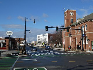
Somerville is a city located directly to the northwest of Boston, and north of Cambridge, in Middlesex County, Massachusetts, United States. As of the 2020 United States Census, the city had a total population of 81,045 people. With an area of 4.12 square miles (10.7 km2), the city has a density of 19,671/sq mi (7,595/km2), making it the most densely populated municipality in New England and the 16th most densely populated incorporated municipality in the country. Somerville was established as a town in 1842, when it was separated from Charlestown. In 2006, the city was named the best-run city in Massachusetts by The Boston Globe. In 1972, 2009, and 2015, the city received the All-America City Award. It is home to Tufts University, which has its campus along the Somerville and Medford border.

<span class="mw-page-title-main">Charlestown, Boston</span> Neighborhood of Boston in Massachusetts, United States

Charlestown is the oldest neighborhood in Boston, Massachusetts, in the United States. Originally called Mishawum by the Massachusett tribe, it is located on a peninsula north of the Charles River, across from downtown Boston, and also adjoins the Mystic River and Boston Harbor waterways. Charlestown was laid out in 1629 by engineer Thomas Graves, one of its earliest settlers, during the reign of Charles I of England. It was originally a separate town and the first capital of the Massachusetts Bay Colony.

<span class="mw-page-title-main">Union Square (Somerville)</span> Neighborhood in Somerville, Massachusetts

<span class="mw-page-title-main">Inman Square</span> Neighborhood in Cambridge Massachusetts

Inman Square is a neighborhood and historic district in Cambridge, Massachusetts. It lies north of Central Square, at the junction of Cambridge, Hampshire, and Inman Streets near the Cambridge–Somerville border.

<span class="mw-page-title-main">Lechmere station</span> Light rail station in Cambridge, Massachusetts, US

Lechmere station is a Massachusetts Bay Transportation Authority (MBTA) Green Line light rail station in Lechmere Square in East Cambridge, Massachusetts. It is located on the east side of Monsignor O'Brien Highway near First Street, adjacent to the NorthPoint development. The accessible elevated station has a single island platform, with headhouses at both ends. It opened on March 21, 2022, as part of the Green Line Extension (GLX). Lechmere station is served by Green Line D branch and E branch service.

The Canal Street incline was a ramp connecting two transit tunnels in Boston with surface and elevated lines. It was located in the Bulfinch Triangle between North Station and Haymarket Square in two blocks bounded by Canal Street to the west, Causeway Street to the north, Haverhill Street to the east, and Market Street to the south. The incline was the north end of the Tremont Street subway and the Washington Street Tunnel. Built in 1898, it remained in use until 2004 when the last connecting line was moved underground.

The Charles River Dam Bridge, officially the Craigie Bridge, also called Craigie's Bridge or the Canal Bridge, is a six-lane bascule bridge across the Charles River in the West End neighborhood of Boston. The bridge, maintained by the Massachusetts Department of Conservation and Recreation, carries Massachusetts Route 28 next to the Green Line's Lechmere Viaduct. The Museum of Science is located on the dam and nearby piers. Charles River Dam Road connects Leverett Circle in the West End to East Cambridge, but most of the road is fixed, and the asymmetrically sited drawbridge is a short span entirely on the Boston side of the river.

The Urban Ring was a proposed project of the Massachusetts Bay Transportation Authority and the Massachusetts Department of Transportation, to develop new public transportation routes that would provide improved circumferential connections among many existing transit lines that project radially from downtown Boston. The Urban Ring Corridor is located roughly one to two miles from downtown Boston, passing through the Massachusetts cities of Boston, Chelsea, Everett, Medford, Somerville, Cambridge, and Brookline. The project was expected to convert 41,500 car trips to transit trips daily.

<span class="mw-page-title-main">Community College station</span> Rapid transit station in Charlestown, Massachusetts, US

Community College station is a rapid transit station on the MBTA Orange Line in Boston, Massachusetts. It is located in the Charlestown neighborhood off Austin Street near New Rutherford Avenue (MA-99), under the double-decked elevated structure carrying Interstate 93 to the Zakim Bunker Hill Bridge. The station is named for the adjacent Bunker Hill Community College. The station opened in April 1975, replacing the City Square and Thompson Square stations of the Charlestown Elevated. It was made accessible around 2005.

<span class="mw-page-title-main">CambridgeSide</span> Shopping mall in Cambridge, Massachusetts, United States

CambridgeSide is an enclosed shopping mall in Cambridge, Massachusetts that opened in 1990. As of 2023, the mall is anchored by TJ Maxx. Previous anchors include department stores Filene's, Lechmere, Macy's, Macy's Home and Children's, and Sears.

North Point is a neighborhood within the East Cambridge section of Cambridge, Massachusetts. A former railroad yard, the site was originally built by the Boston and Maine Railroad. It is triangular in shape and bound by the MBTA Commuter Rail Fitchburg Line, the Charles River and associated dam with the Lechmere Viaduct, the former Lechmere wetlands, and Millers River remnant that once divided Cambridge and Charlestown, along with the Interstate 93 Northern Expressway viaduct to the northeast.

<span class="mw-page-title-main">Causeway Street elevated</span>

The Causeway Street elevated was an elevated section of the MBTA Green Line light rail system in Boston, located in the area near North Station. It was in operation from 1912 until 2004, when it was replaced with a new tunnel and underground station on a slightly different alignment.

<span class="mw-page-title-main">Lechmere Viaduct</span> Bridge over the Charles River in Boston

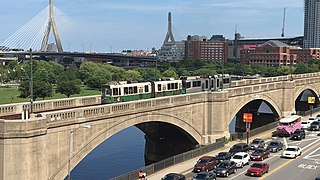
The Lechmere Viaduct is a concrete arch bridge connecting the West End neighborhood of Boston to East Cambridge, Massachusetts. Opened in 1912, the viaduct carries the MBTA's Green Line over the Charles River. It is adjacent to the Charles River Dam Bridge, but structurally separate.

<span class="mw-page-title-main">North Point Park (Massachusetts)</span> Park in Massachusetts, United States

North Point Park is an 8.5-acre (3.4 ha) park located along the north side of the Charles River in Cambridge, Massachusetts and Boston's West End, created as mitigation for the taking of planned parkland for the construction of the Big Dig.

<span class="mw-page-title-main">Green Line Extension</span> Light rail system extension

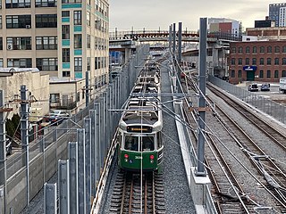
The Green Line Extension (GLX) was a construction project to extend the Massachusetts Bay Transportation Authority (MBTA) Green Line light rail system northwest into Somerville and Medford, two inner suburbs of Boston, Massachusetts. The project opened in two phases in 2022 at a total cost of $2.28 billion. Total ridership on the 4.3-mile (6.9 km) extension is estimated to reach 45,000 one-way trips per day in 2030.

<span class="mw-page-title-main">Sullivan Square</span>

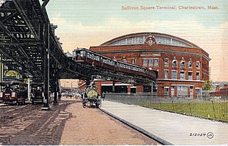
Sullivan Square is a traffic circle located at the north end of the Charlestown neighborhood of Boston, Massachusetts. It is named after James Sullivan, an early 19th-century Governor of Massachusetts. Sullivan Square station on the MBTA Orange Line is located just west of the square.

<span class="mw-page-title-main">Millers River (Middlesex)</span> River in Middlesex County, Massachusetts, United States

Millers River was a river in Middlesex County, Massachusetts. It has since mostly been obscured by landfill and "made land". The small remaining estuary is a remnant of wetlands and open water that once divided Cambridge from Charlestown, Massachusetts. The exact historical course of parts the river is somewhat uncertain, and thus parts of the Charlestown-Cambridge and Somerville-Cambridge borders may have changed due to incorrect historical reconstruction.

<span class="mw-page-title-main">Andrew Craigie</span>

Andrew Craigie (1754-1819) is best known for serving as the first Apothecary General of the Continental Army during the American Revolution. The one-time owner of the Longfellow House–Washington's Headquarters National Historic Site, Craigie developed much of East Cambridge, Massachusetts and was responsible for the construction of the Canal Bridge connecting East Cambridge and Boston, which later became known as the Craigie Bridge and later was rebuilt as the Charles River Dam Bridge, but which is still also referred to as Craigie's Bridge.

References

  1. "Archived copy" (PDF). Archived from the original (PDF) on 2010-06-05. Retrieved 2009-02-06.{{cite web}}: CS1 maint: archived copy as title (link)
  2. 1 2 3 City of Cambridge, Massachusetts (1978). "East Cambridge Riverfront Plan". Archived from the original on 2011-05-23. Retrieved 2012-01-05.
  3. American Experience | Patriots Day | Maps | PBS
  4. Dearborn, Nathaniel S. (1822). "A new & complete map of the city of Boston, with part of Charlestown, Cambridge & Roxbury" . Retrieved 2012-01-07.
  5. 1 2 Cambridge City Engineer (1922). "Map of the City of Cambridge" . Retrieved 2012-01-05.
  6. "Storrow Drive and Memorial Drive at Night". 2004. Archived from the original on 2012-02-05. Retrieved 2012-01-16.
  7. "Memorial Drive Poster" (PDF). Retrieved 2012-01-16.[ permanent dead link ]
  8. City of Cambridge Community Development Department (2002). "Cambridge Riverfront Plan" (PDF). Archived from the original (PDF) on 2011-11-25. Retrieved 2012-01-16.
  9. "Camb Info" (PDF). Archived from the original (PDF) on 2012-01-28. Retrieved 2012-01-07.
  10. Lisinski, Chris (February 24, 2022). "Green Line Extension service to begin March 21". WBUR. Retrieved February 25, 2022.
  11. 1 2 "East Cambridge, MA Household Income, Population & Demographics | Point2". www.point2homes.com. Retrieved 2022-05-15.
  12. Parry, Manon S. (2006-04-01). "Dorothea Dix (1802–1887)". American Journal of Public Health. 96 (4): 624–625. doi:10.2105/AJPH.2005.079152. ISSN   0090-0036. PMC   1470530 .

42°22′00″N71°04′48″W / 42.36667°N 71.08000°W / 42.36667; -71.08000