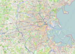
Cambridge is a city in Middlesex County, Massachusetts, United States. It is a suburb in the Greater Boston metropolitan area, located directly across the Charles River from Boston. The city's population as of the 2020 U.S. census was 118,403, making it the most populous city in the county, the fourth-largest in Massachusetts behind Boston, Worcester, and Springfield, and ninth-most populous in New England. The city was named in honor of the University of Cambridge in Cambridge, England, which was an important center of the Puritan theology that was embraced by the town's founders.
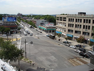
Kendall Square is a neighborhood in Cambridge, Massachusetts, United States. The square itself is at the intersection of Main Street and Broadway. It also refers to the broad business district east of Portland Street, northwest of the Charles River, north of MIT and south of Binney Street.
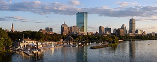
Back Bay is an officially recognized neighborhood of Boston, Massachusetts, built on reclaimed land in the Charles River basin. Construction began in 1859, as the demand for luxury housing exceeded the availability in the city at the time, and the area was fully built by around 1900. It is most famous for its rows of Victorian brownstone homes—considered one of the best preserved examples of 19th-century urban design in the United States—as well as numerous architecturally significant individual buildings, and cultural institutions such as the Boston Public Library, and Boston Architectural College. Initially conceived as a residential-only area, commercial buildings were permitted from around 1890, and Back Bay now features many office buildings, including the John Hancock Tower, Boston's tallest skyscraper. It is also considered a fashionable shopping destination and home to several major hotels.

Dorchester is a neighborhood comprising more than 6 square miles (16 km2) in the City of Boston, Massachusetts, United States. Originally, Dorchester was a separate town, founded by Puritans who emigrated in 1630 from Dorchester, Dorset, England, to the Massachusetts Bay Colony. This dissolved municipality, Boston's largest neighborhood by far, is often divided by city planners in order to create two planning areas roughly equivalent in size and population to other Boston neighborhoods.

Harvard Square is a triangular plaza at the intersection of Massachusetts Avenue, Brattle Street and John F. Kennedy Street near the center of Cambridge, Massachusetts, United States. The term "Harvard Square" is also used to delineate the business district and Harvard University surrounding that intersection, which is the historic center of Cambridge. Adjacent to Harvard Yard, the historic heart of Harvard University, the Square functions as a commercial center for Harvard students, as well as residents of western Cambridge, the western and northern neighborhoods and the inner suburbs of Boston. The Square is served by Harvard station, a major MBTA Red Line subway and a bus transportation hub.
Union Square is a neighborhood in the southeastern part of Somerville, Massachusetts, United States. It is centered on Union Square proper, which is located at the intersection of Washington Street, Webster Avenue, and Somerville Avenue.

Inman Square is a neighborhood and historic district in Cambridge, Massachusetts. It lies north of Central Square, at the junction of Cambridge, Hampshire, and Inman Streets near the Cambridge–Somerville border.

Kendall/MIT station is an underground rapid transit station in Cambridge, Massachusetts. It is served by the MBTA Red Line. Located at the intersection of Main Street and Broadway, it is named for the primary areas it serves - the Kendall Square business district and the Massachusetts Institute of Technology (MIT). Opened in March 1912 as part of the original Cambridge subway, Kendall/MIT has two side platforms serving the line's two tracks. The Kendall Band, a public art installation of hand-operated musical sculptures, is located between the tracks in the station with controls located on the platforms. Kendall/MIT station is accessible. With 17,018 weekday boardings by a FY2019 count, Kendall/MIT has the fourth highest ridership among MBTA subway stations.
Allston is an officially recognized neighborhood in Boston, Massachusetts, United States. It was named after the American painter and poet Washington Allston. It comprises the land covered by the zip code 02134. For the most part, Allston is administered collectively with the adjacent neighborhood of Brighton. The two are often referred to together as Allston–Brighton. Boston Police Department District D-14 covers the Allston-Brighton area and a Boston Fire Department Allston station is located in Union Square which houses Engine 41 and Ladder 14. Engine 41 is nicknamed "The Bull" to commemorate the historic stockyards of Allston.

The Massachusetts Bay Transportation Authority (MBTA) operates two specially designated crosstown bus routes in the Boston, Massachusetts, United States area, called CT2 and CT3, and intended as limited-stop buses connecting major points. The two weekday-only routes largely parallel MBTA bus local routes, but with fewer stops to reduce travel times.

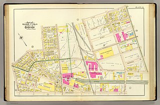
Cambridgeport is one of the neighborhoods of Cambridge, Massachusetts. It is bounded by Massachusetts Avenue, the Charles River, the Grand Junction Railroad, and River Street. The neighborhood contains predominantly residential homes, many of the triple decker style common in New England. Central Square, at the northernmost part of Cambridgeport, is an active commercial district and transportation hub, and University Park is a collection of renovated or recently constructed office and apartment buildings. The neighborhood also includes Fort Washington Park, several MIT buildings, and Magazine Beach.
The Urban Ring was a proposed project of the Massachusetts Bay Transportation Authority and the Massachusetts Department of Transportation, to develop new public transportation routes that would provide improved circumferential connections among many existing transit lines that project radially from downtown Boston. The Urban Ring Corridor is located roughly one to two miles from downtown Boston, passing through the Massachusetts cities of Boston, Chelsea, Everett, Medford, Somerville, Cambridge, and Brookline. The project was expected to convert 41,500 car trips to transit trips daily.

Memorial Drive, colloquially referred to as Mem Drive, is a 3.9-mile (6.3 km) parkway along the north bank of the Charles River in Cambridge, Massachusetts, United States.

University Park at MIT is a mixed-use urban renewal project in Cambridge, Massachusetts, United States, occupying land near Central Square between the Massachusetts Institute of Technology (MIT) campus and the primarily residential neighborhood of Cambridgeport. It is a joint project of the City of Cambridge, MIT, and Brookfield Asset Management. It is not part of the MIT campus.
The Port, formerly Area 4, is a neighborhood of Cambridge, Massachusetts, roughly between Central Square, Inman Square, and MIT. It is bounded on the south by Massachusetts Avenue, on the west by Prospect Street, on the north by Hampshire Street, and on the east by the Grand Junction Railroad tracks. Area 4 is a densely populated residential neighborhood with about 7,000 residents.

The Margaret Fuller House was the birthplace and childhood home of American transcendentalist Margaret Fuller (1810–1850). It is located at 71 Cherry Street, in the Old Cambridgeport Historic District area of Cambridge, Massachusetts, in the neighborhood now called "The Port". The house is now a National Historic Landmark.

Christ The King Presbyterian Church is a Presbyterian Church in America (PCA) church, founded in 1995. It occupies the historic building of the former Prospect Congregational Church, located at 99 Prospect Street in Cambridge, Massachusetts near Central Square.

The New England Confectionery Company Factory, also known as the NECCO Candy Factory, is a historic factory complex at 250 Massachusetts Avenue in Cambridge, Massachusetts. The property is now owned by DFS Advisors, and is under long-term lease to Novartis. The complex, which includes the factory building, a power plant, and a modern (2003) parking garage, occupies most of an entire city block bounded by Massachusetts Avenue, Cross Street, Albany Street, and Lansdowne Street. The Moderne-style building was constructed of reinforced concrete, faced predominantly with beige brick and trimmed with limestone. On some facades smooth concrete predominates as the finish surface. The building had a water tower that was painted to resemble a roll of Necco Wafers; during the alterations of the property for use by Novartis, the water tower was retained, and is now painted with a DNA pattern in pastel colors. The building was listed on the National Register of Historic Places in 2005.

The Salem–Auburn Streets Historic District is a residential historic district at Salem and Auburn Streets in Cambridge, Massachusetts. The district includes a collection of houses that is among the oldest in the Cambridgeport section of the city, and includes most of the houses on two blocks of these streets. The district was added to the National Register of Historic Places in 1982.

Union Square is a square in the Allston neighborhood of Boston, Massachusetts at the intersection of Cambridge Street and Brighton Avenue/North Beacon Street. Union Square is serviced by the MBTA 57, 64, 66, 501, and 503 buses. There is also a station for the Blue Bikes bicycle sharing system in Union Square.