
Gettysburg National Cemetery is a United States national cemetery in Gettysburg, Pennsylvania created for Union casualties from the Battle of Gettysburg in the American Civil War. The Battle of Gettysburg, which was fought between July 1 to 3, 1863, resulted in the largest number of casualties of any Civil War battle but also was considered the war's turning point, leading ultimately to the Union victory.

The Gettysburg Battlefield is the area of the July 1–3, 1863 military engagements of the Battle of Gettysburg within and around the borough of Gettysburg, Pennsylvania. Locations of military engagements extend from the 4-acre (1.6 ha) site of the first shot at Knoxlyn Ridge on the west of the borough, to East Cavalry Field on the east. A military engagement prior to the battle was conducted at the Gettysburg Railroad trestle over Rock Creek, which was burned on June 27.
Cemetery Hill is a landform on the Gettysburg Battlefield that was the scene of fighting each day of the Battle of Gettysburg. The northernmost part of the Army of the Potomac defensive "fish-hook" line, the hill is gently sloped and provided a site for American Civil War artillery.

Little Round Top is the smaller of two rocky hills south of Gettysburg, Pennsylvania—the companion to the adjacent, taller hill named Big Round Top. It was the site of an unsuccessful assault by Confederate troops against the Union left flank on July 2, 1863, the second day of the Battle of Gettysburg, during the American Civil War.

Culp's Hill, which is about 3⁄4 mi (1,200 m) south of the center of Gettysburg, Pennsylvania, played a prominent role in the Battle of Gettysburg. It consists of two rounded peaks, separated by a narrow saddle. Its heavily wooded higher peak is 630 ft (190 m) above sea level. The lower peak is about 100 feet shorter than its companion. The eastern slope descends to Rock Creek, about 160 feet lower in elevation, and the western slope is to a saddle with Stevens Knoll with a summit 100 ft (30 m) lower than the main Culp's Hill summit. The hill was owned in 1863 by farmer Henry Culp and was publicized as "Culp's Hill" by October 31, 1865.

Cemetery Ridge is a geographic feature in Gettysburg National Military Park, south of the town of Gettysburg, Pennsylvania, that figured prominently in the Battle of Gettysburg, July 1 to July 3, 1863. It formed a primary defensive position for the Union Army during the battle, roughly the center of what is popularly known as the "fish-hook" line. The Confederate States Army launched attacks on the Union positions on the second and third days of the battle, but were driven back both times.

Devil's Den is a boulder-strewn hill on the south end of Houck's Ridge at Gettysburg Battlefield, used by artillery and sharpshooters on the second day of the 1863 Battle of Gettysburg during the American Civil War. A tourist attraction since the memorial association era, several boulders are worn from foot traffic and the site includes numerous cannons, memorials, and walkways, including a bridge spanning two boulders.

Seminary Ridge is a dendritic ridge that served as an area of military engagements during the Battle of Gettysburg, the bloodiest battle of the American Civil War, which was fought between July 1 and July 3, 1863 in and around Gettysburg, Pennsylvania. Seminary Ridge also served as a military installation during World War II.

Big Round Top is a boulder-strewn hill notable as the topographic high point of the Gettysburg Battlefield and for 1863 American Civil War engagements for which Medals of Honor were awarded. In addition to battle monuments, a historic reconstruction era structure on the uninhabited hill is the Big Round Top Observation Tower Foundation Ruin.

Rock Creek is an 18.9-mile-long (30.4 km) tributary of the Monocacy River in south-central Pennsylvania and serves as the border between Cumberland and Mount Joy townships. Rock Creek was used by the Underground Railroad and flows near several Gettysburg Battlefield sites, including Culp's Hill, the Benner Hill artillery location, and Barlow Knoll.

Evergreen Cemetery – formerly called Citizen's Cemetery and Ever Green Cemetery – is a historic 29.12 acre rural cemetery located just outside Gettysburg Borough, in Cumberland Township, Adams County, Pennsylvania, United States. It is part of Gettysburg Battlefield Historic District, and is surrounded by Gettysburg National Military Park and Soldiers' National Cemetery.

The 75th Ohio Infantry Regiment, sometimes 75th Ohio Volunteer Infantry was an infantry regiment from southwestern Ohio in the Union Army during the American Civil War. It served in the Eastern Theater, most notably in the battles of Chancellorsville and Gettysburg and then in the siege operations against Charleston, South Carolina.
Sylvanus Tunning Rugg was an officer in the Union Army who commanded an artillery battery at the Battle of Gettysburg during the American Civil War, as well as in other leading battles of the Army of the Potomac. He also served in the Western Theater late in his career.

The Pennsylvania State Memorial is a monument in Gettysburg National Military Park that commemorates the 34,530 Pennsylvania soldiers who fought in the July 1 to 3, 1863 Battle of Gettysburg during the American Civil War. The memorial stands along Cemetery Ridge, the Union battle line on July 2, 1863. Completed in 1914, it is the largest of the state monuments on the Gettysburg Battlefield.
Emmor Cope (1834-1927) was an American Civil War officer of the Union Army noted for the "Map of the Battlefield of Gettysburg from the original survey made August to October, 1863", which he researched by horseback as a sergeant after being ordered back to Gettysburg by Maj. Gen. George G. Meade. Cope is also noted for commemorative era battlefield administration and designs, including the layout of the 1913 Gettysburg reunion. Cope had enlisted as a Private of Company A,, temporarily detached to Battery C, 5th U.S. Artillery, and mustered out as a V Corps aide-de-camp of Maj Gen Gouverneur K. Warren.

The Wheatfield Road is a Gettysburg Battlefield crossroad from the Peach Orchard east-southeastward along the north side of The Wheatfield, north of the Valley of Death, and over the north foot of Little Round Top. In addition to modern tourist use, the road is notable for Battle of Gettysburg use and postbellum trolley use associated with the 1892-1896 US v. Gettysburg Electric Ry. case of the US Supreme Court.
The Gettysburg Battlefield Memorial Association (GBMA) was an historic preservation membership organization and is the eponym for the battlefield's memorial association era. The association was chartered by the Commonwealth of Pennsylvania on April 13, 1864, after attorney David McConaughy recommended on August 14, 1863, a preservation association to sell membership stock for battlefield fundraising. McConaughy transferred his land acquired in 1863 to the GBMA, and the association's boardmembers were initially local officials. The GBMA sold stock to raise money, hired a superintendent at $1000/yr, added to McConaughy's land holdings, and operated a wooden observation tower on East Cemetery Hill from 1878–95.

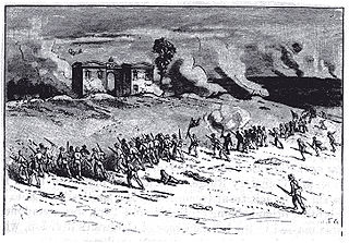
Evergreen Cemetery gatehouse (1855) is a historic building located at 799 Baltimore Pike in Adams County, Pennsylvania. During the American Civil War, the gatehouse played an important role in the July 1 to 3, 1863 Battle of Gettysburg. It is a contributing structure in Gettysburg Battlefield Historic District.

McPherson Ridge is a landform used for military engagements during the 1863 Battle of Gettysburg, when the I Corps of the Union Army had a headquarters on the ridge and was defeated by the Confederate division of Major General Henry Heth. The ridge has terrain above ~530 ft (160 m) and is almost entirely a federally protected area except for township portions at the southern end and along Pennsylvania Route 116, including a PennDOT facility. The northern end is a slight topographic saddle point on the west edge of Oak Ridge, and summit areas above 560 ft (170 m) include 4 on/near the Lincoln Highway, a broader summit south of the Fairfield Road, and the larger plateau at the northern saddle.

The 44th and 12th New York Infantry Monument is a Gettysburg Battlefield memorial erected near the summit of Little Round Top to commemorate combat in the Battle of Little Round Top. The castellated building is the largest monument to a regiment on the battlefield, is the 1st of only 2 Battle of Gettysburg memorials with observation decks, and supplemented the Gettysburg Battlefield Memorial Association wooden towers on Big Round Top and East Cemetery Hill. The July 3, 1893, memorial dedication was the site of an altercation against photographer William H. Tipton by Gen. Sickles, who was served a court writ the following day and was forced out of the New York Monuments Commission in 1912 after malfeasance.
