East Duke, Oklahoma

Last updated

East Duke, Oklahoma
OKMap-doton-EastDuke.PNG
Location of East Duke, Oklahoma
Coordinates: 34°39′46″N99°34′11″W / 34.66278°N 99.56972°W / 34.66278; -99.56972
Country United States
State Oklahoma
County Jackson
Area
[1]
  Total0.43 sq mi (1.13 km2)
  Land0.43 sq mi (1.13 km2)
  Water0.00 sq mi (0.00 km2)
Elevation
[2]
1,421 ft (433 m)
Population
 (2020)
  Total394
  Density905.75/sq mi (350.06/km2)
Time zone UTC-6 (Central (CST))
  Summer (DST) UTC-5 (CDT)
ZIP code
73532
Area code 580
FIPS code 40-22550 [3]
GNIS feature ID2412459 [2]

East Duke, now known as Duke, is a town in Jackson County, Oklahoma, United States. The population was 394 as of the 2020 United States census. [4] It is located about 14 miles west of the county seat of Altus, and is located at the intersection of US Route 62 and Oklahoma State Highway 34. [5]

Contents

History

The town of Duke was founded in 1890. [6] Speculation about the location of a projected railroad sparked a separation in the community, creating an old town called West Duke, and a new town called East Duke. [6] While the community reconciled in 1915 when the parties literally buried a hatchet delivered in a horse-drawn hearse, West Duke did not ultimately survive, and East Duke is now known simply as Duke. [6]

Geography

According to the United States Census Bureau, the town has a total area of 0.4 square miles (1.0 km2), all land.

Demographics

Historical population
CensusPop.Note
1920 502
1930 5438.2%
2000 445
2010 424−4.7%
2020 394−7.1%
U.S. Decennial Census [7]

As of the census of 2010, there were 424 people living in the town. [8] The population density was 1,024.2 inhabitants per square mile (395.4/km2). There were 201 housing units at an average density of 459 per square mile (177/km2). [8] The racial makeup of the town was 88.31% White, 0.22% African American, 0.67% Native American, 0.90% Asian, 5.17% from other races, and 4.72% from two or more races. Hispanic or Latino of any race were 9.44% of the population.

There were 172 households, [8] out of which 36.2% had children under the age of 18 living with them, 66.1% were married couples living together, 8.0% had a female householder with no husband present, and 24.7% were non-families. 20.7% of all households were made up of individuals, and 11.5% had someone living alone who was 65 years of age or older. The average household size was 2.56 and the average family size was 2.98.

In the town, the population was spread out, with 28.1% under the age of 18, 7.4% from 18 to 24, 29.7% from 25 to 44, 21.3% from 45 to 64, and 13.5% who were 65 years of age or older. The median age was 35 years. For every 100 females, there were 104.1 males. For every 100 females age 18 and over, there were 89.3 males.

The median income for a household in the town was $33,942, and the median income for a family was $39,063. Males had a median income of $30,673 versus $16,875 for females. The per capita income for the town was $16,739. About 4.7% of families and 8.5% of the population were below the poverty line, including 12.7% of those under age 18 and 9.4% of those age 65 or over.

Related Research Articles

<span class="mw-page-title-main">Jackson County, Oklahoma</span> County in Oklahoma, United States

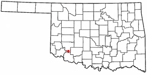
Jackson County is a county located in the southwestern corner of the U.S. state of Oklahoma. As of the 2020 census, the population was 24,785. Its county seat is Altus. According to the Encyclopedia of Oklahoma History and Culture, the county was named for two historical figures: President Andrew Jackson and Confederate General Stonewall Jackson. One source states that the county was named only for the former president, while an earlier source states it was named only for General Stonewall Jackson.

<span class="mw-page-title-main">Denning, Arkansas</span> Town in Arkansas, United States

Denning is a town in Franklin County, Arkansas, United States. It is part of the Fort Smith, Arkansas-Oklahoma Metropolitan Statistical Area. The population was 314 at the 2010 census, up from 270 at the 2000 census.

<span class="mw-page-title-main">Wiederkehr Village, Arkansas</span> City in Arkansas, United States

Wiederkehr Village is a city in Franklin County, Arkansas, United States. It is part of the Fort Smith, Arkansas-Oklahoma Metropolitan Statistical Area. The population was 38 at the 2010 census. It is named after Swiss winemaker Johann Andreas Wiederkehr, who immigrated to the area in 1880.

<span class="mw-page-title-main">Sawyer, Oklahoma</span> Town in Oklahoma, United States

Sawyer is a town in Choctaw County, Oklahoma, United States. The population was 321 at the 2010 census.

<span class="mw-page-title-main">Amber, Oklahoma</span> Town in Oklahoma, United States

Amber is a town in Grady County, Oklahoma, United States. The population was 413 at the 2020 census, a 1.4% decrease from 2010.

<span class="mw-page-title-main">Bradley, Oklahoma</span> Town in Oklahoma, United States

Bradley is a town in Grady County, Oklahoma, United States. The population was 78 at the 2020 United States census.

<span class="mw-page-title-main">Granite, Oklahoma</span> Town in Oklahoma, United States

Granite is a town in Greer County, Oklahoma, United States. The population was 1,628 at the 2020 census.

<span class="mw-page-title-main">Altus, Oklahoma</span> City in Oklahoma, United States

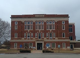
Altus is a city in and the county seat of Jackson County, Oklahoma, United States. The population was 18,729 at the 2020 census.

<span class="mw-page-title-main">Headrick, Oklahoma</span> Town in Oklahoma, United States

Headrick is a town in Jackson County, Oklahoma, United States. The population was 94 at the 2010 census, down from 130 in 2000.

<span class="mw-page-title-main">Martha, Oklahoma</span> Town in Oklahoma, United States

Martha is a town in Jackson County, Oklahoma, United States. The population was 162 as of the 2020 United States census. The town is located about 9 driving miles north-northwest of the county seat of Altus.

<span class="mw-page-title-main">Olustee, Oklahoma</span> Town in Oklahoma, United States

Olustee is a town in Jackson County, Oklahoma, United States. "Olustee" is said to be a Seminole word meaning "pond" or from the Creek (Muscogee) language ue-lvste (/oy-lást-i/) meaning "black water", and being taken from the Battle of Olustee in Florida. The population was 468 as of the 2020 United States census.

<span class="mw-page-title-main">Lone Wolf, Oklahoma</span> Town in Oklahoma, United States

Lone Wolf is a town in Kiowa County, Oklahoma, United States. The population was 438 at the 2010 census, a decline of 12.4 percent from 500 in 2000. The town was named for Chief Lone Wolf (1843–1923), a warrior chief of the Kiowa who fought to preserve his people's autonomy and way of life.

<span class="mw-page-title-main">Mountain Park, Oklahoma</span> Town in Oklahoma, United States

Mountain Park is a town in Kiowa County, Oklahoma, United States. The population was 409 at the 2010 census, a 4.9 percent increase from 390 in 2000.

<span class="mw-page-title-main">Snyder, Oklahoma</span> City in Oklahoma, United States

Snyder is a city in Kiowa County, Oklahoma, United States. The population was 1,394 at the 2010 census. This figure represented a decline of 7.6 percent from 1,509 persons in 2000.

<span class="mw-page-title-main">Davenport, Oklahoma</span> Town in Oklahoma, United States

Davenport is a town in Lincoln County, Oklahoma, United States. The population was 814 at the 2010 census.

<span class="mw-page-title-main">Kendrick, Oklahoma</span> Town in Oklahoma, United States

Kendrick is a town in Lincoln County, Oklahoma, United States. The population was 139 at the 2010 census.

<span class="mw-page-title-main">Tryon, Oklahoma</span> Town in Oklahoma, United States

Tryon is a town in Lincoln County, Oklahoma, United States. The population was 491 at the 2010 census. The community is named after early land owner Fred S. Tryon.

<span class="mw-page-title-main">Warwick, Oklahoma</span> Town in Oklahoma, United States

Warwick is a town in Lincoln County, Oklahoma, United States. The population was 184 at the 2020 census, up from 148 in 2010.

<span class="mw-page-title-main">Byars, Oklahoma</span> Town in Oklahoma, United States

Byars is a town in McClain County, Oklahoma, United States. The population was 184 at the 2020 census, down from 255 at the 2010 census.

<span class="mw-page-title-main">Lake Aluma, Oklahoma</span> Town in Oklahoma, United States

Lake Aluma is a town in Oklahoma County, Oklahoma, United States, and a part of the Oklahoma City Metropolitan Area. The population was 88 at the 2010 census.

References

  1. "ArcGIS REST Services Directory". United States Census Bureau. Retrieved September 20, 2022.
  2. 1 2 U.S. Geological Survey Geographic Names Information System: East Duke, Oklahoma
  3. "U.S. Census website". United States Census Bureau . Retrieved January 31, 2008.
  4. "East Duke (town), Oklahoma". United States Census Bureau. Retrieved March 16, 2024.
  5. "Duke, Oklahoma to Altus, Oklahoma". Google Maps. Retrieved March 16, 2024.
  6. 1 2 3 "Duke". Oklahoma Historical Society. Retrieved March 17, 2024.
  7. "Census of Population and Housing". Census.gov. Retrieved June 4, 2016.
  8. 1 2 3 "2010 City Population and Housing Occupancy Status". U.S. Census Bureau. Retrieved October 18, 2013.[ dead link ]

Notable people Logan Harrod