Friendship, Oklahoma

Last updated

Friendship, Oklahoma
Friendship Hist Mkr.png
Friendship state historical marker
USA Oklahoma location map.svg
Red pog.svg
Friendship
Usa edcp location map.svg
Red pog.svg
Friendship
Coordinates: 34°41′52″N99°13′43″W / 34.69778°N 99.22861°W / 34.69778; -99.22861
Country United States
State Oklahoma
County Jackson
Area
[1]
  Total0.15 sq mi (0.39 km2)
  Land0.15 sq mi (0.39 km2)
  Water0.00 sq mi (0.00 km2)
Elevation
[2]
1,394 ft (425 m)
Population
 (2020)
  Total23
  Density153.33/sq mi (59.20/km2)
Time zone UTC-6 (Central (CST))
  Summer (DST) UTC-5 (CDT)
Area code 580
FIPS code 40-27900 [3]
GNIS feature ID2412660 [2]

Friendship is an incorporated town in Jackson County, Oklahoma, United States. The population was 23 as of the 2020 United States census, [4] just down one person from the 2010 census figure of 24. [3]

Contents

History

Before Oklahoma became the 46th state, Friendship was located in Indian Territory, Oklahoma Territory, and Greer County, Texas. [5] :1 [6]

Southwestern Oklahoma was once part of a vast sea of grass stretching as far as the eye could see, populated by millions of buffalo and claimed by Texas, but ruled by the Comanche and Kiowa people. [5] :1 After the last free bands of Comanche and Kiowa were confined to the reservation at Fort Sill in 1875, the area became safe for cattle drives. From 1876 to 1892, millions of longhorns were driven from Texas to Dodge City, Kansas, and Ogallala, Nebraska, over the Great Western Cattle Trail which passed through the middle of what is now Friendship. [5] :6 [6]

In 1880, giant Texas cattle companies, attracted by the rich grazing land, started moving into southwestern Oklahoma. At that time, the area was claimed by Texas as Greer County, based on its assertion that the North Fork of the Red River was the main channel of the Red River. In 1890, the Oklahoma Territory was created, and a lawsuit was filed by the United States to resolve the boundary dispute. In 1896, the U.S. Supreme Court determined that the area was a part of the Oklahoma Territory, not Texas, and it was opened for homesteading in 1897. [5] :8 [6]

Over the years, a number of communities, including Clabber Flat, Alfalfa, Lone Oak, Ricks, Riverside, Pleasant Point and Navajoe, were settled in the Friendship area. Clabber Flat School, which opened in 1899, became the first Friendship School, changing its name to Friendship because of its association with the Friendship Baptist Church, which was organized and often met at the school. [5] :12 [6]

Friendship was originally known as "Alfalfa" and was the site of the Alfalfa Post Office from 1903 to 1905. In 1908, the Friendship Baptist Church was built at Alfalfa, and the town soon became known as "Friendship". [5] :13,43 In 1920, the Friendship and Navajoe School Districts, and parts of the Lone Oak and Riverside School Districts, consolidated to form a new Friendship Consolidated District. In 1935, Pleasant Point consolidated with Friendship, and in later years, students were gained from the Ozark and Headrick School Districts. [5] :39,51 [6]

Friendship thrived during the first part of the 20th century. At its peak, the town included two service stations, two grocery stores, two cotton gins, two blacksmith shops, a garage, a hardware store, a barber shop, a cafe, a feed mill, a domino parlor and as many as twenty residences. [5] :38 [6] In addition to the Friendship Baptist Church within the town, the Midway Methodist Church was constructed in 1913, one mile east of the town. [5] :32

After World War II, improved transportation allowed area residents to take their trade to Altus, and there was a pronounced exodus from the farm to the city. One by one, the businesses in Friendship closed. [5] :38 After the Friendship School burned in 1962, Friendship and Warren schools were consolidated to form a new school district known as Navajo, which built a new school midway between the two towns in 1963. [5] :53 [6] [7] 1982 marked the closing of the Midway Methodist Church. [5] :34

Today

Western Cattle Trail state historical marker W Cattle Trail Marker.png
Western Cattle Trail state historical marker

Incorporated in 1999, Friendship has seen a recent increase in residential construction in its vicinity. However, only the Friendship Baptist Church, a community center (which houses the Friendship Volunteer Fire Department) and a few residences actually exist within the town limits. [6]

Geography

Friendship is in northeastern Jackson County, 10 miles (16 km) by road northeast of the center of Altus, the county seat.

According to the U.S. Census Bureau, Friendship has an area of 0.15 square miles (0.39 km2), all land. [3]

Demographics

Historical population
CensusPop.Note
2010 24
2020 23−4.2%
U.S. Decennial Census [8]

Related Research Articles

<span class="mw-page-title-main">Yoakum County, Texas</span> County in Texas, United States

Yoakum County is a county located in the far western portion of the U.S. state of Texas. As of the 2020 census, the population was 7,694. Its county seat is Plains. The county was created in 1876 and later organized in 1907. It is named for Henderson King Yoakum, a Texas historian.

<span class="mw-page-title-main">Tillman County, Oklahoma</span> County in Oklahoma, United States

Tillman County is a county located in the southwestern part of Oklahoma, United States. As of the 2020 census, the population was 6,968. The county seat is Frederick.

<span class="mw-page-title-main">Kiowa County, Oklahoma</span> County in Oklahoma, United States

Kiowa County is a county located in the southwestern part of the U.S. state of Oklahoma. As of the 2020 census, the population was 8,509. Its county seat is Hobart. The county was created in 1901 as part of Oklahoma Territory. It was named for the Kiowa people.

<span class="mw-page-title-main">Jackson County, Oklahoma</span> County in Oklahoma, United States

Jackson County is a county located in the southwestern corner of the U.S. state of Oklahoma. As of the 2020 census, the population was 24,785. Its county seat is Altus. According to the Encyclopedia of Oklahoma History and Culture, the county was named for two historical figures: President Andrew Jackson and Confederate General Stonewall Jackson. One source states that the county was named only for the former president, while an earlier source states it was named only for General Stonewall Jackson.

<span class="mw-page-title-main">Harmon County, Oklahoma</span> County in Oklahoma, United States

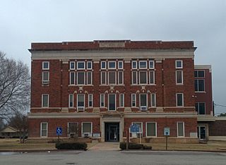
Harmon County is a county in the southwest corner of the U.S. state of Oklahoma. As of the 2020 Census, the population was 2,488, making it the second-least populous county in Oklahoma, behind only Cimarron County. It has lost population in every census since 1930. The county seat is Hollis.

<span class="mw-page-title-main">Greer County, Oklahoma</span> County in Oklahoma, United States

Greer County is a county located along the southwest border of the U.S. state of Oklahoma. As of the 2020 census, the population was 5,491. Its county seat is Mangum. From 1860 to 1896, the state of Texas claimed an area known as Greer County, Texas, which included present-day Greer County along with neighboring areas. In 1896 it was designated as a county in Oklahoma Territory under a ruling by the US Supreme Court. The rural Greer County is home to Quartz Mountain State Park, near the community of Lone Wolf, Oklahoma. It is also home to the Oklahoma State Reformatory, located in Granite. Its population has declined since 1930 due to changes in agriculture and migration to cities for work.

<span class="mw-page-title-main">Grady County, Oklahoma</span> County in Oklahoma, United States

Grady County is a county located in the U.S. state of Oklahoma. As of the 2020 census, the population was 54,795. Its county seat is Chickasha. It was named for Henry W. Grady, an editor of the Atlanta Constitution and southern orator.

<span class="mw-page-title-main">Ellis County, Oklahoma</span> County in Oklahoma, United States

Ellis County is a county located on the western border of the U.S. state of Oklahoma. As of the 2020 census, the population was 3,749, making it the fifth-least populous county in Oklahoma. Its county seat is Arnett.

<span class="mw-page-title-main">Comanche County, Oklahoma</span> County in Oklahoma, United States

Comanche County is a county located in the U.S. state of Oklahoma. As of the 2020 census, the population was 121,125, making it the fifth-most populous county in Oklahoma. Its county seat is Lawton. The county was created in 1901 as part of Oklahoma Territory. It was named for the Comanche tribal nation.

<span class="mw-page-title-main">Caddo County, Oklahoma</span> County in Oklahoma, United States

Caddo County is a county located in the U.S. state of Oklahoma. As of the 2020 census, the population was 26,945. Its county seat is Anadarko. Created in 1901 as part of Oklahoma Territory, the county is named for the Caddo tribe who were settled here on a reservation in the 1870s. Caddo County is immediately west of the seven-county Greater Oklahoma City metro area, and although is not officially in the metro area, it has many economic ties in this region.

<span class="mw-page-title-main">Anadarko, Oklahoma</span> City in Oklahoma, United States

Anadarko is a city in Caddo County, Oklahoma, United States. The city is fifty miles (80.5 km) southwest of Oklahoma City. The population was 5,745 at the 2020 census. It is the county seat of Caddo County.

<span class="mw-page-title-main">Lawton, Oklahoma</span> City in Oklahoma, United States

Lawton is a city in and the county seat of Comanche County, in the U.S. state of Oklahoma. Located in southwestern Oklahoma, approximately 87 mi (140 km) southwest of Oklahoma City, it is the principal city of the Lawton, Oklahoma, metropolitan statistical area. According to the 2020 census, Lawton's population was 90,381, making it the sixth-largest city in the state, and the largest in Western Oklahoma.

<span class="mw-page-title-main">Mangum, Oklahoma</span> City in Oklahoma, United States

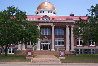
Mangum is a city in and county seat of Greer County, Oklahoma, United States. The population was 3,010 at the 2010 census. It was originally part of Old Greer County in the Texas panhandle. The community was named for A. S. Mangum, who owned the land on which the town was founded in 1882. It became part of the Oklahoma Territory in 1896, and thus part of the state of Oklahoma on November 16, 1907.

<span class="mw-page-title-main">Altus, Oklahoma</span> City in Oklahoma, United States

Altus is a city in and the county seat of Jackson County, Oklahoma, United States. The population was 18,729 at the 2020 census.

<span class="mw-page-title-main">Woodward, Oklahoma</span> City in Oklahoma, United States

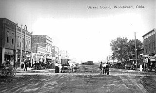
Woodward is a city in and the county seat of Woodward County, Oklahoma, United States. It is the largest city in a nine-county area. The population was 12,133 at the time of the 2020 census.

<span class="mw-page-title-main">Oklahoma's 3rd congressional district</span> U.S. House district for Oklahoma

Oklahoma's 3rd congressional district is the largest congressional district in the state, covering an area of 34,088.49 square miles, over 48 percent the state's land mass. The district is bordered by New Mexico, Colorado, Kansas, and the Texas panhandle. Altogether, the district includes a total of 32 counties, and covers more territory than the state's other four districts combined. It is one of the largest districts in the nation that does not cover an entire state.

<span class="mw-page-title-main">Southwestern Oklahoma</span>

Southwest Oklahoma is a geographical name for the southwest portion of the state of Oklahoma, typically considered to be south of the Canadian River, extending eastward from the Texas border to a line roughly from Weatherford, to Anadarko, to Duncan. Geologically, the region is defined by a failed continental rift known as the Southern Oklahoma Aulacogen. The austere nature of the prairie landscape with intermittent island ranges has made it a favorable place for artists and photographers alike. For tourism purposes, the Oklahoma Tourism and Recreation Department has designated Southwestern Oklahoma as Great Plains Country, and defined it to consist of 14 counties including Roger Mills, Custer, Beckham, Washita, Caddo, Kiowa, Greer, Harmon, Jackson, Comanche, Tillman, Cotton, Stephens, and Jefferson counties.

<span class="mw-page-title-main">Quartz Mountains</span> Mountains in the US state Oklahoma

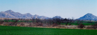
The Quartz Mountains are an extension of the Wichita Mountains in the far southwestern part of the state of Oklahoma. According to the Encyclopedia of Oklahoma History and Culture, the range was originally formed about 550 million years ago as a "failed continental rift". It was uplifted about 300 million years ago and has since weathered into its current condition. The unique geography provides cover for the most northerly natural population of the Texas live oak, quercus fusiformis. This rare oak is generally regarded as the most cold hardy evergreen oak.

<span class="mw-page-title-main">Navajoe, Oklahoma</span> Ghost Town in Oklahoma, United States

Navajoe is a ghost town in Jackson County, Oklahoma, United States, located eight miles east and four miles north of Altus at the base of the Navajo Mountains.

Driftwood is a small unincorporated community in northern Alfalfa County, Oklahoma, United States. A formerly prosperous small rural community, at one time it had two churches, a grocery store, barber shop, gas station with repair shop, grain elevator, two-story school, a telephone office, bank, and post office. Currently, it is made up of less than a dozen residences - along with a church and cemetery - grouped along both sides of Oklahoma State Highway 8/State Highway 58.

References

  1. "ArcGIS REST Services Directory". United States Census Bureau. Retrieved September 20, 2022.
  2. 1 2 U.S. Geological Survey Geographic Names Information System: Friendship, Oklahoma
  3. 1 2 3 "Geographic Identifiers: 2010 Census Summary File 1 (G001): Friendship town, Oklahoma". American Factfinder. U.S. Census Bureau. Archived from the original on February 13, 2020. Retrieved October 17, 2018.
  4. "Friendship (town), Oklahoma". United States Census Bureau. Retrieved March 16, 2024.
  5. 1 2 3 4 5 6 7 8 9 10 11 12 The Early Day Friendship Area: Its Settlement and Communities, Friendship History Group (2002).
  6. 1 2 3 4 5 6 7 8 History of Friendship, Oklahoma, Verna Biddy Johnson and Don Butler. http://www.rootsweb.ancestry.com/~okfhg/
  7. Navajo(e): A Raid, A Battle and A Postscript, Prairie Lore, Volume 48, No. 1, Don Butler (2011)
  8. "Census of Population and Housing". Census.gov. Retrieved June 4, 2015.