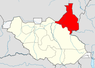
Upper Nile is a state in South Sudan. The White Nile flowes through the state, giving it its name. The state also shares a similar name with the region of Greater Upper Nile, of which it was part along with the states of Unity and Jonglei. It had an area of 77,823 square kilometres (30,048 sq mi). Malakal was the capital of the state. The towns of Upper Nile State Benythieng Akoka, Maluth, Renk, Kodok, the location of the Fashoda Incident that ended the "Scramble for Africa", was located in the state. Upper Nile seceded from Sudan as part of the Republic of South Sudan on 9 July 2011.
Renk is a town in South Sudan.

The States of South Sudan were created out of the three historic former provinces of Bahr el Ghazal (northwest), Equatoria (southern), and Greater Upper Nile (northeast). The states are further divided into 79 counties.
Melut County is an administrative area in the Upper Nile State.
Baliet is an administrative county in the Upper Nile State, South Sudan. The County headquarters is the town of Baliet, located on the north side of the Sobat River 20 km south east of Malakal, the capital city of Upper Nile State.
Makal is a county in the Upper Nile State. Previously, it was a part of Upper Nile, South Sudan.

Eastern Lakes State was a state in South Sudan that existed between 2 October 2015 and 22 February 2020. It was located in the Bahr el Ghazal region and it bordered Southern Liech to the north, Western States to the west, Amadi to the southwest, Terekeka to the southeast, and Jonglei to the east.

Imatong State was a state in South Sudan that existed between 2 October 2015 and 22 February 2020. It was located in the Equatoria region and it bordered Yei River to the southwest, Jubek to the west, Terekeka and Jonglei to the northwest, Boma to the northeast, Namorunyang to the east, and Uganda to the south.

Terekeka State was a state in South Sudan that existed between 2 October 2015 and 22 February 2020. It was located in the Equatoria region and it bordered Amadi, Eastern Lakes, Imatong, Jonglei, and Jubek. It has an estimated population of 176,030 in 2014, and the capital and largest city of the state is Terekeka, South Sudan.

Boma State was a state in South Sudan that existed between 2 October 2015 and 22 February 2020. It was located in the Greater Upper Nile region and was formerly part of the state of Jonglei. The state bordered Akobo State, Imatong State, Jonglei State, Kapoeta State, Bieh State, Terekeka State and the country of Ethiopia to the east.

Bieh State was a state in South Sudan that existed between 2 October 2015 and 22 February 2020. It was located in the Greater Upper Nile region and it bordered Fangak to the west, Central Upper Nile to the north, Latjoor and Akobo to the east, and Jonglei to the south.

Latjoor was a state in South Sudan that existed between 2 October 2015 and 22 February 2020. It was located in the Greater Upper Nile region and it bordered Eastern Nile to the north, Eastern Bieh to the south, and Ethiopia to the east.

Northern Liech was a state in South Sudan that existed between 2 October 2015 and 22 February 2020. It was located in the Greater Upper Nile region and it bordered Ruweng to the north, Western Bieh to the east, Southern Liech to the south, Tonj to the south, and Gogrial and Twic to the west.

The Ruweng Administrative Area is an administrative area in South Sudan. The area was known as Ruweng State between 2 October 2015 and 22 February 2020 when it was a state of South Sudan.

Southern Liech State was a state in South Sudan that existed between 2 October 2015 and 22 February 2020. It was located in the Greater Upper Nile region and it bordered Northern Liech to the north, Western Bieh to the east, Jonglei to the southeast, Eastern Lakes to the south, Western Lakes to the southwest, and Tonj to the west.

Fangak State was a state in South Sudan that existed between 2 October 2015 and 22 February 2020. It was located in the Greater Upper Nile region and it bordered Ruweng to the northwest, Western Nile to the northeast, Eastern Nile to the east, Eastern Bieh to the southeast, Jonglei to the south, Southern Liech to the southwest, and Northern Liech to the west.

Fashoda State was a state in South Sudan that existed between 2 October 2015 and 22 February 2020. It was located in the Greater Upper Nile region of South Sudan, and it bordered the country of Sudan to the north, and the southern Sudanese states of Eastern Nile to the east, Western Bieh to the southwest, and Ruweng to the west.
James Kok Ruey has been the Governor of Western Bieh State, South Sudan since 24 December 2015. He is the first governor of the state, which was created by President Salva Kiir on 2 October 2015. James Kok is currently an MP in National parliament representing Pangak constituency since 2021. He previously served as the Minister of Humanitarian Affairs and Disaster Management and later a Member of Parliament, representing Fangak County in Jonglei. In 2001, he represented the Sudan People's Defense Forces/Democratic Front in negotiations with the Sudan People's Liberation Army, incurring the wrath of less conciliatory SPDF members who saw cooperation as betrayal.
This article lists events from the year 2019 in South Sudan
James Tor Monybuny is a South Sudanese politician who has been the deputy governor of Upper Nile State since January 2021, and was the first governor of Central Upper Nile State from 2017-2019. Monybuny is from Baliet, and is a member of the Ngok Lual Yak section of the Padang Dinka. Earlier in his career, Monybuny was a pastor for the Presbyterian Church in South Sudan and the Baliet County commissioner.
