
Sackville—Preston—Chezzetcook is a federal electoral district in Halifax, Nova Scotia, Canada, that has been represented in the House of Commons of Canada since 1997.

The Eastern Shore is a region of the Canadian province of Nova Scotia. It is the Atlantic coast running northeast from Halifax Harbour to the eastern end of the peninsula at the Strait of Canso.
The Halifax Regional Municipality (HRM) in Nova Scotia, Canada has a widely varied geography.

The Musquodoboit River is a Canadian river located in central Nova Scotia in the northeastern part of Halifax Regional Municipality. The river is approximately 97 kilometres (60 mi) in length with roughly 88 kilometres (55 mi) being traversable by paddle. It has a watershed area of 1,409 square kilometres (544 sq mi)
The Tobeatic Wilderness Area is the largest protected area in the Canadian Maritimes, located in southwestern Nova Scotia. It contains nearly 120,000 hectares of land and spans parts of five counties, Annapolis, Digby, Queens, Shelburne and Yarmouth. Located adjacent to Kejimkujik National Park, it was formerly known as the Tobeatic Wildlife Management Area, and the Tobeatic Game Reserve.
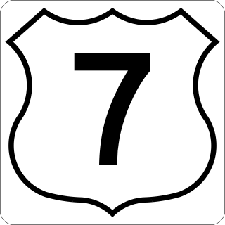
Nova Scotia Trunk 7 is part of the Canadian province of Nova Scotia's system of Trunk Highways. The route runs from Bedford to Antigonish, along the Eastern Shore for a distance of 269 kilometres (167 mi). Part of Trunk 7 is known as the Marine Drive.
The Marine Drive is a designated scenic route along Nova Scotia's Eastern Shore. It closely follows the coast of the Atlantic Ocean and the Strait of Canso from the Canso Causeway to the junction of Route 322 and Highway 111 in Dartmouth.
Musquodoboit Harbour is a natural harbour in Canada on the Eastern Shore of Nova Scotia.

Musquodoboit Harbour is a rural community located in Nova Scotia, Canada within the Halifax Regional Municipality. The community is situated on the Eastern Shore at the mouth of the Musquodoboit River. The community lies 45 kilometres east of downtown Halifax. With a hospital, RCMP detachment, postal outlet, schools, recreational center, library, municipal office and other services, Musquodoboit Harbour is a serve centre for many of the surrounding communities.

Nova Scotia is a province located in Eastern Canada fronting the Atlantic Ocean. One of the Maritime Provinces, Nova Scotia's geography is complex, despite its relatively small size in comparison to other Canadian provinces.

Eastern Shore District High School is a public school in the Musquodoboit Harbour area east of Dartmouth, Nova Scotia, Canada. It is operated by the Halifax Regional Centre for Education (HRCE).
Gibraltar is a rural community of the Halifax Regional Municipality in the Canadian province of Nova Scotia on Nova Scotia Route 357, approximately 15 km north of Musquodoboit Harbour.

Eunice Lake is a lake located in the Ship Harbour Long Lake Wilderness Area in Nova Scotia, Canada. It can only be accessed by the Admiral Lake Loop of the Musquodoboit Trailways Association. The lake is about 320 meters long and 190 meters wide. The trailhead is about 2 km north of Musquodoboit Harbour.

The White Lake Wilderness Area is a wilderness area located in Nova Scotia, Canada, in Halifax Regional Municipality. Several trails, all maintained by the Musquodoboit Trailways Association, pass through it; Gibraltar Rock Loop, White Lake Wilderness Trails, the Musquodoboit Rail Trail, the Bayers Lake Loop, and the Admiral Lake loop. Access to much of the remainder of the wilderness area is possible only by canoe, requiring multiple portages to get to some of the more remote lakes.
The Waverley - Salmon River Long Lake Wilderness Area is a provincial wilderness area located about 20 kilometers east of Dartmouth Nova Scotia, Canada.
The Musquodoboit Trailway is a 14.5-kilometre-long (9.0 mi) multiuse rail trail located in Halifax County, Nova Scotia, running the distance from Gibralter to Musquodoboit Harbour. The entire route is part of the Halifax spur of The Great Trail, and follows Nova Scotia Route 357 for its length.

The Eastern Shore is a tourism region of the province of Nova Scotia, Canada. It provides two percent of the revenue for the province's tourism economy. One of its key features is an archipelago known as the 100 Wild Islands area.

Tangier Grand Lake Wilderness Area is a relatively large wilderness area located within the province of Nova Scotia, Canada, centered on its namesake lake, Tangier Grand Lake, the largest lake in Nova Scotia which does not have direct road access.

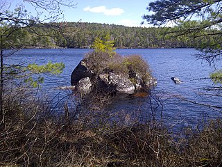
Moose Cove Lake is a lake located in Halifax County, Nova Scotia, approximately 3.3 kilometres (2.1 mi) due north of Salmon River Bridge. The lake is located within the Ship Harbour Long Lake Wilderness Area.


