
Paterson is the largest city in and the county seat of Passaic County, New Jersey, United States.

Forest Hill is an unincorporated community and neighborhood within the city of Newark in Essex County, New Jersey, United States. It is a pre-World War II neighborhood in the North Ward. It is bounded on the west by Branch Brook Park, on the south by Bloomfield Avenue, and on the east by both Summer and Mt. Prospect Avenues, the neighborhood of Broadway. The neighborhood's ZIP code is 07104.
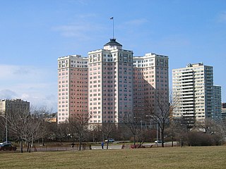
The Bryn Mawr Historic District is on the lakefront of the Edgewater neighborhood of far-north Chicago, Illinois. It extends along Bryn Mawr Avenue between Broadway Avenue and Sheridan Road. Its most prominent features are the Belle Shore Apartment Hotel, Bryn Mawr Apartment Hotel, Edgewater Beach Apartments, Edgewater Presbyterian Church, Manor House, and the northernmost area of Lincoln Park.

Skylands is a 1,119 acres (4.5 km²) estate property located in Ringwood State Park in Ringwood, New Jersey, a borough in Passaic County in the state of New Jersey. The Skylands property consists of the historic Skylands Manor mansion, The Castle at Skylands Manor and the New Jersey Botanical Garden; the botanical garden is 96-acre (390,000 m2) and it is open to the public year-round. The Skylands property is within the Ramapo Mountains and it is maintained by the Skyland Association. The property is marketed with the garden as New Jersey State Botanical Garden at Skylands.
Downtown Paterson is the main commercial district of Paterson, Passaic County, New Jersey, United States. The area is the oldest part of the city, along the banks of the Passaic River and its Great Falls. It is roughly bounded by Interstate 80, Garret Mountain Reservation, Route 19, Oliver Street, and Spruce Street on the south; the Passaic River, West Broadway, Cliff Street, North 3rd Street, Haledon Avenue, and the borough of Prospect Park on the west; and the Passaic River also to the north.
Eastside is a neighborhood in Paterson, New Jersey, United States. It is bordered by South Paterson, Downtown Paterson, Riverside and the Passaic River It is bound by 10th Avenue and Montgomery Street to the north, Straight Street to the west, I-80 to the south and the river to the east. It is Paterson's largest neighborhood and includes the smaller neighborhoods of Sandy Hill, People's Park, Eastside Park Historic District and the Manor Section. Eastside is a mostly residential area with commercial centers along 33rd Street and Broadway. It is also home to Eastside Park, Paterson's largest park.

Riverside is a larger neighborhood in Paterson, New Jersey and, as its name states, this neighborhood is bound by the Passaic River to the west, north and east, separating the city from Hawthorne and offering 5 major crossings into the Greater Paterson Borough of Fair Lawn, giving residents access to NJ Transits Urban Local-Hoboken PATH Connect Train Line in the Radburn and Broadway Districts, easily accessible by Bus, car, or walking, as well as keeping Jewish, Muslim, Baptist, Eastern Orthodox, etc. Religious Communities and families within walking distance of relatives, places of Worship, and other points of interests within the East Rivers 07514-07410 neighborhoods. It is loosely bounded in the south by 10th Avenue and Montgomery Street from the Eastside neighborhood, but it is common for anyone who lived, lives, or frequents the area the boundary using the word "Riversude" begins, from South to North, at Broadway to 1st/Maple Ave. and, from West to East, from Madison Ave to River Rd, to call their neighborhood "Riverside" within the sub-Culture of the 07514-07410 East River area, typically referred to as "River Rats", named after the 2 ft Long Rats that can be seen swimming, flipping or basking in the Sun in and around the East River. Riverside is mostly a quiet working-class neighborhood. The neighborhood is mostly residential with some industrial uses. Madison Avenue cuts through the heart of this district, but to many this is a loose boundary with Madison Ave. being the Western boundary, while Route 20 runs through the eastern border of Riverside providing an easy commute to Route 80 East and New York City. However, traditionally "Riverside" ended at River Rd. This section is ethnically diverse with a growing Hispanic community concentrating mostly north and along River Street. African Americans and Caribbean blacks live south of River Street. Many Albanians make their home in the East 18th Street and River Street areas. River View Terrace is located in this neighborhood. Riverside is located in parts of the 3rd and 4th Wards of Paterson.
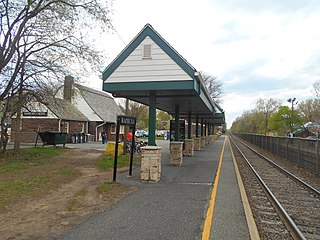
Radburn is a New Jersey Transit train station in the Dutch Colonial Revival style, served by the Bergen County Line. It is on Fair Lawn Avenue in the Radburn section of Fair Lawn, in Bergen County, New Jersey, United States. It is one of two New Jersey Transit train stations in Fair Lawn, the other being Broadway.

The Old Dauphin Way Historic District is a historic district in the city of Mobile, Alabama, United States. It was named for Dauphin Way, now known as Dauphin Street, which bisects the center of the district from east to west. The district is roughly bounded by Broad Street on the east, Springhill Avenue on the north, Government Street on the south, and Houston Avenue on the west. Covering 766 acres (3.10 km2) and containing 1466 contributing buildings, Old Dauphin Way is the largest historic district in Mobile.

The Broadway Historic District in Bangor, Maine, United States, bounded by Garland, Essex, State, Park, and Center Streets, is one of the residential neighborhoods most favored by the city's lumber barons and business elites in the early to late 19th century. A second and slightly later Bangor neighborhood of primarily elite houses, centered on West Broadway, is also listed on the National Register of Historic Places as the Whitney Park Historic District. Both historic districts are also protected under local ordinance.

The Whitney Avenue Historic District is a historic district in the East Rock neighborhood of New Haven, Connecticut. It is a 203-acre (82 ha) district which included 1,084 contributing buildings when it was listed on the National Register of Historic Places in 1989.
Bergen-Lafayette is a section of Jersey City, New Jersey.

The Prospect Park Historic District in Davenport, Iowa, United States, is a historic district that was listed on the National Register of Historic Places in 1984. In its 23.2-acre (9.4 ha) area, it included 23 contributing buildings in 1984. The Prospect Park hill was listed on the Davenport Register of Historic Properties in 1993.

Forest Park is a Victorian garden district located in Springfield, Massachusetts, developed between 1880 and 1920. It is the city's most populous neighborhood, and surrounds the 735-acre Frederick Law Olmsted–designed Forest Park, for which the neighborhood is named. The Forest Park neighborhood has nature and recreation within walking distance. To the west, I-91 separates Forest Park from the Connecticut River. A 195-acre section of the neighborhood was listed on the National Register of Historic Places in 1982 as the Forest Park Heights Historic District.

The Ashby Manor Historic District is located in northwest Des Moines, Iowa, United States. It is a residential area that lies between Beaver Avenue, which is a major north-south artery, on the west and Ashby Park on the east. The historic period of the housing was 1925-1941. The street layout follows a curving pattern, which differentiates it from the grid pattern of the surrounding area. The streets also feature a mature tree canopy. The historic district has 148 properties of which 99 are houses and 49 are garages. Ninety-one properties are considered contributing properties and 57 are noncontributing. It has been listed on the National Register of Historic Places since 1992. It is a part of the Suburban Development in Des Moines Between the World Wars, 1918--1941 MPS.
Fred Wesley Wentworth was an American architect known for his many buildings in Downtown Paterson, New Jersey as well as several residences and theaters in northeastern New Jersey. Wentworth had a major impact on shaping Paterson after a wind-driven fire decimated much of the central business district in 1902. His body of work consisted of institutional, commercial, residential, religious and healthcare buildings as well as some of the nation's first movie theaters designed exclusively for motion pictures. He was a Fellow of the American Institute of Architects.

Eastside Park is a park located in Paterson, New Jersey. The park is bordered by Martin Luther King, Jr. Way (Broadway) to the north, McLean Boulevard to the east, Park Avenue to the south, and Derrom Avenue to the west. Eastside Park is the cornerstone of the Eastside Park Historic District, a state and nationally registered historic place added to the National Register of Historic Places on July 7, 2004.

Andrew Derrom was an English-American civil engineer, industrialist, inventor, and military officer.
The North Jefferson Avenue Historic District is a small residential historic district located at the intersection of Carroll and Jefferson Avenues in Saginaw, Michigan. It was listed on the National Register of Historic Places in 1982.


