Passaic County is a county in the U.S. state of New Jersey that is part of the New York metropolitan area. As of the 2020 United States census, the county was the state's eighth-most-populous county, with a population of 524,118, its highest decennial count ever and an increase of 22,892 (+4.6%) from the 2010 census count of 501,226, which in turn reflected an increase of 12,177 (+2.5%) from the 489,049 counted in the 2000 census. The most populous place in Passaic County is Paterson, with 159,732 residents at the 2020 Census, more than 29% of the county's population, while West Milford covered 80.32 square miles (208.0 km2), the largest total area of any municipality and more than 40% of the county's area.
West Milford is a township in Passaic County, in the U.S. state of New Jersey. As of the 2020 United States census, the township's population was 24,862, a decrease of 988 (−3.8%) from the 2010 census count of 25,850, which in turn reflected a decline of 560 (−2.1%) from the 26,410 counted in the 2000 census. It is the largest in the county by total area, covering 80.32 square miles (208.0 km2) and more than 40% of the county.
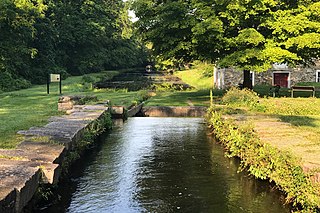
The Morris Canal (1829–1924) was a 107-mile (172 km) common carrier anthracite coal canal across northern New Jersey that connected the two industrial canals at Easton, Pennsylvania across the Delaware River from its western terminus at Phillipsburg, New Jersey to New York Harbor and New York City via its eastern terminals in Newark and on the Hudson River in Jersey City. The canal was sometimes called the Morris and Essex Canal, in error, due to confusion with the nearby and unrelated Morris and Essex Railroad.
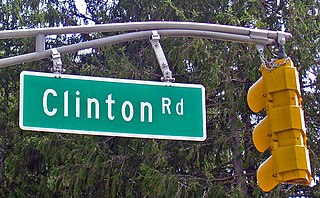
Clinton Road is located in West Milford, Passaic County, New Jersey, United States. It runs in a generally north–south direction, beginning at Route 23 near Newfoundland and running roughly 10 mi (16 km) to its northern terminus at Upper Greenwood Lake.

Meramec State Park is a public recreation area located near Sullivan, Missouri, about 60 miles from St. Louis, along the Meramec River. The park has diverse ecosystems such as hardwood forests and glades. There are over 40 caves located throughout the park, the bedrock is dolomite. The most famous is Fisher Cave, located near the campgrounds. The park borders the Meramec Conservation Area.

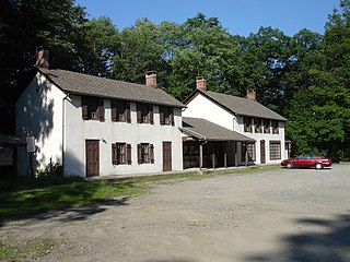
Ringwood Manor, located in Passaic County, New Jersey, was the site of an ironworks and home to a number of well-known ironmasters from the 1740s to the late 19th century. The current manor house was not built until 1807.
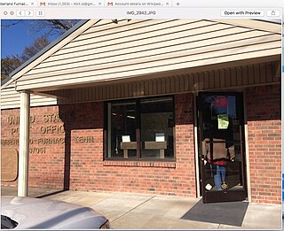
Cumberland Furnace is an unincorporated community in Dickson County, Tennessee, United States. Cumberland Furnace is served by a U.S. Post Office, ZIP Code 37051.
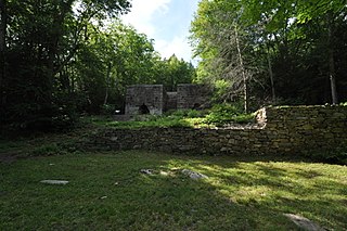
Long Pond Ironworks State Park is located in the community of Hewitt, in West Milford, New Jersey, United States. The park is known for its old stone walls, furnaces and other remnants of a once industrious ironworking community that now sits next to the swiftly flowing Wanaque River. The park is operated and maintained by the New Jersey Division of Parks and Forestry and has an area of 145 acres (0.59 km2).

Cornwall Furnace is located near Cedar Bluff, Alabama in Cherokee County. It was built by the Noble Brothers to supply iron products to the Confederate States of America during the American Civil War.

The John Winthrop Jr. Iron Furnace Site is a historic archaeological site at 61 Crescent Street, Quincy, Massachusetts. The site is called Braintree Furnace in some texts; the West Quincy location at the time of operation was in a part of Braintree, Massachusetts, that later became Quincy. Its importance lies in the fact that it was the first iron blast furnace established in what would become the United States. Furnace Brook, a stream which begins on the eastern slopes of the Blue Hills and meanders for about four miles from southwest to northeast through the middle of Quincy toward Quincy Bay, was named for the works site.

The Brierfield Furnace, also known as the Bibb Naval Furnace and Brierfield Ironworks, is a historic district in Brierfield, Alabama, encompassed by Brierfield Ironworks Historical State Park. The district covers 486 acres (197 ha) and includes one building and nine sites. It was listed on the National Register of Historic Places on November 20, 1974.
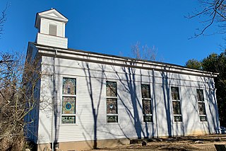
Cokesbury, historically known as Cokesburg, is an unincorporated community located on the border of Clinton and Tewksbury townships in Hunterdon County, New Jersey. It was named after two Methodist bishops, Coke and Asbury. The Cokesbury Historic District was listed on the state and national registers of historic places in 1997.

The Clay Street Bridge is a bridge on the Passaic River between Newark and East Newark, New Jersey. The swing bridge is the 13th bridge from the river's mouth at Newark Bay and is 6.1 miles (9.8 km) upstream from it. Opened in 1903, the Warren through truss rim-bearing bridge was substantially rehabilitated in 1975–1976, its original working parts are now part of the collection of the Newark Museum. It is listed on the New Jersey Register of Historic Places (ID#5153) and is eligible for the National Register of Historic Places.

The Beckley Furnace Industrial Monument is a state-owned historic site preserving a 19th-century iron-making blast furnace on the north bank of the Blackberry River in the town of North Canaan, Connecticut. The site became a 12-acre (4.9 ha) state park in 1946; it was added to the National Register of Historic Places in 1978.

Washington Iron Furnace is an historic iron furnace, located in Rocky Mount, Franklin County, Virginia. The granite furnace was built around 1770, and measures 30 feet high on its south face. It helped establish industry in the county, and was listed on the National Register of Historic Places in 1973.
Tranquility Ridge Park is a 2,062 acre Watershed Protection Area that spans the border of Ringwood and West Milford, New Jersey, United States, and is directly south of the New Jersey-New York State Line. Tranquility Ridge Park is directly adjacent to Sterling Forest State Park in NY, and Long Pond Ironworks State Park in NJ. The area was once part of Long Pond Ironworks, which was developed as an ironworks "plantation" by Peter Hasenclever in 1766, and produced iron for American forces during the American Revolutionary War, the War of 1812, and the American Civil War.
Mine Hills Preserve is a natural and historical conservation area on Mine Hills Road in northwestern Roxbury, Connecticut. Owned by the Roxbury Land Trust, it protects the site of a well-preserved 19th-century iron mine and furnace works. Several miles of trails provide access to abandoned quarry areas and the preserved remains of the iron works, whose uses are explained by informational panels. The preserve is open from dawn to dusk. The 360-acre (150 ha) preserve was listed on the National Register of Historic Places in 1979.

The New Hampton Pony Pratt Truss Bridge is a historic pony Pratt truss bridge on Shoddy Mill Road in New Hampton of Lebanon Township, Hunterdon County, New Jersey. It crosses the Musconetcong River between Lebanon Township, Hunterdon County and Washington Township, Warren County. It was designed by Francis C. Lowthorp and built in 1868 by William Cowin of Lambertville, New Jersey. The bridge was added to the National Register of Historic Places on July 26, 1977 for its significance in engineering, industry and transportation. It is one of the few early examples of iron Pratt truss bridges remaining in the United States. It was later documented by the Historic American Engineering Record in 1991. It was added as a contributing property to the New Hampton Historic District on April 6, 1998.
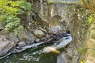
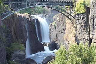
The Arch Bridge from the Boonton Ironworks crosses the Rockaway River in Grace Lord Park in the town of Boonton in Morris County, New Jersey. The single-span fieldstone arch bridge was built by John Carson Sr. in 1866 to carry a water pipe to the ironworks. It was added to the National Register of Historic Places on September 1, 2022, for its significance in engineering. It is currently used as a pedestrian bridge.


