Clay County is located in the U.S. state of Missouri and is part of the Kansas City metropolitan area. As of the 2020 census, the county had a population of 253,335, making it the fifth-most populous county in Missouri. Its county seat is Liberty. The county was organized January 2, 1822, and named in honor of U.S. Representative Henry Clay from Kentucky, later a member of the United States Senate and United States Secretary of State.

The Fishing River is a 39.0-mile-long (62.8 km) tributary of the Missouri River in western Missouri in the United States. It rises in the northeastern extremity of Kansas City in Clay County and flows generally eastward and southeastward through Clay and southeastern Ray counties, past the town of Mosby. It joins the Missouri River about 3 miles (5 km) south of the town of Orrick.

The 2016 United States House of Representatives elections in Missouri were held on November 8, 2016, to elect the eight U.S. representatives from the state of Missouri, one from each of the state's eight congressional districts. The elections coincided with the 2016 U.S. presidential election, as well as other elections to the House of Representatives, elections to the United States Senate and various state and local elections. The primaries were held on August 2.
Clay is an unincorporated community in Adair County, in the U.S. state of Missouri.
Claysville is an unincorporated community in Boone County, in the U.S. state of Missouri. It is the southernmost settlement in Boone County. Claysville is near the Missouri River.
Arley is an unincorporated community in Clay County, in the U.S. state of Missouri.
Chandler is an unincorporated community in Clay County, in northwest Missouri. The community is on the Burlington Northern Railroad Line between Liberty and Kearney. Holmes Creek flows past the community.
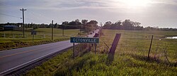
Claysville is an unincorporated community in Clay County, Missouri, United States.
Clevenger is an unincorporated community in Clay County, in the U.S. state of Missouri.
Miltondale is an unincorporated community in Clay County, in the U.S. state of Missouri.
Paradise is an unincorporated community in northwest Clay County, in the U.S. state of Missouri. The community lies between the two arms of the Smithville Lake on the Little Platte River. The city of Smithville lies across the lake to the southwest. The community is located along Missouri Route W about four miles southeast of Trimble in adjacent Clinton County.
Stockdale is an unincorporated community in Clay County, Missouri, United States. It was so named because livestock was shipped by rail from its depot.
Winner is an unincorporated community in Clay County, in the U.S. state of Missouri.
Haynesville is an unincorporated community in southern Clinton County, in the U.S. state of Missouri. The community lies about one quarter mile east of I-35 and north of Missouri Route PP. The community of Holt is located approximately two miles to the southwest on the west side of I-35 in northern Clay County.
Robbins is an unincorporated community in Johnson County, in the U.S. state of Missouri.
Heather is an unincorporated community in Marion County, in the U.S. state of Missouri.
Turners Mill is an extinct town in eastern Oregon County, in the U.S. state of Missouri. The GNIS classifies it as a populated place. The mill was adjacent to Turners Spring on the north bank of the Eleven Point River.
Elkhorn is an unincorporated community in southwest Ray County, in the U.S. state of Missouri and part of the Kansas City metropolitan area.
Vibbard is an unincorporated community in northwest Ray County, in the U.S. state of Missouri and part of the Kansas City metropolitan area.
Current View is an unincorporated community in Clay County, Arkansas and Ripley County, Missouri, United States. The community straddles the Missouri-Arkansas border on the northeast bank of the Current River. Arkansas Highway 211 connects to the south and Missouri Route E is to the north. Doniphan, Missouri lies approximately eight miles to the north-northwest and Success, Arkansas is about five miles south.