
The Souris River or Mouse River is a river in central North America. Approximately 435 miles (700 km) in length, it drains about 23,600 square miles (61,100 km2) in Canada and the United States.
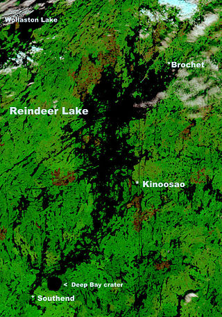
Reindeer Lake is a large lake in Western Canada located on the border between north-eastern Saskatchewan and north-western Manitoba, with the majority in Saskatchewan. The name of the lake appears to be a translation of the Algonquian name. It is the 24th largest lake in the world by area, as well as being the second-largest lake in Saskatchewan and the ninth largest in Canada. Eight percent of the lake lies in Manitoba while 92% of the lake is in Saskatchewan.
North Seal River Airport is located on the shore of Egenolf Lake adjacent to North Seal River, Manitoba, Canada.

Whiteshell Provincial Park is a provincial park in southeast Manitoba, approximately 120 kilometres (75 mi) east of the city of Winnipeg. The park is considered to be a Class II protected area under the IUCN protected area management categories. It is 275,210 hectares in size.
Atikaki Provincial Park is a wilderness park in Manitoba, Canada, located east of Lake Winnipeg along the Ontario boundary in the Canadian Shield. The area of Atikaki Provincial Park is 3,981 square kilometres (1,537 sq mi). Atikaki Provincial Park is north of Nopiming Provincial Park and borders the Woodland Caribou Provincial Park in Ontario.
Treaty 2 was entered in to on 21 August 1872 at Manitoba House, Rupertsland, with representatives of the Queen of Great Britain and Ireland. The original Anishinaabe, who were present, constitute Treaty 2 today. It is known that many of the chiefs and leaders within the territory were at the early gathering and after the treaty was agreed to. Those who were not present were represented through Metis until they indicated where they wished their farming reserves to be established. The treaty reaffirmed the inherent rights that the Anishinaabe had prior to European contact, located where southwestern Manitoba is today and a small part of southeastern Saskatchewan.

Island Lake is a small community in northeast Manitoba, Canada. The community consists of an archipelago near the north shore of Island Lake which includes the following islands: Red Sucker Lake, Garden Hill, Wasagamack, St Theresa point.
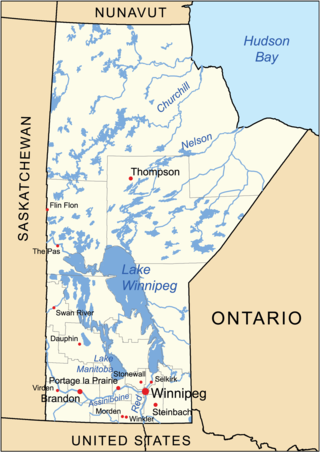
The geography of Manitoba addresses the easternmost of the three prairie Canadian provinces, located in the longitudinal centre of Canada. Manitoba borders on Saskatchewan to the west, Ontario to the east, Nunavut to the north, and the American states of North Dakota and Minnesota to the south. Although the border with Saskatchewan appears straight on large-scale maps, it actually has many right-angle corners that give the appearance of a slanted line. In elevation, Manitoba ranges from sea level on Hudson Bay to 2727 ft (831 m) on top of Baldy Mountain. The northern sixty percent of the province is on the Canadian Shield. The northernmost regions of Manitoba lie permafrost, and a section of tundra bordering Hudson Bay.
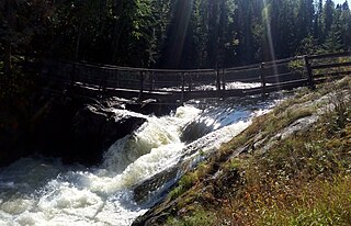
Wekusko Falls Provincial Park is a provincial park straddling the Grass River and Wekusko Lake, located in central Manitoba on Manitoba Provincial Road 392 near Snow Lake, Manitoba.
Stony Lake is a lake in the northern Manitoba, Canada.
Nueltin Lake straddles the Manitoba—Nunavut border in Canada. The lake, which has an area of 2,279 km2 (880 sq mi), is predominantly in Nunavut's Kivalliq Region, and on the Manitoba side there is the Nueltin Lake Airport which serves the fishing lodge. The lake is split into two parts by a set of narrows. It is drained by the Thlewiaza River.
Lake St. Joseph is a large lake in Kenora District and Thunder Bay District in Northwestern Ontario, Canada. It is in the James Bay drainage basin and is the source of the Albany River. The east end of the lake can be reached using Ontario Highway 599 from the town of Ignace, 260 kilometres (160 mi) to the south on Ontario Highway 17. The nearest town is Pickle Lake, 30 kilometres (19 mi) north along Highway 599.
The Seal River is a river in the Northern Region of Manitoba, Canada. It travels 260 kilometres (160 mi) from Shethanei Lake to the Hudson Bay. The river was nominated for the Canadian Heritage Rivers System in 1987 and was officially listed in 1992. In January 2024, the Governments of Canada and Manitoba and Members of the Sayisi Dene First Nation, O-Pipon-Na-Piwin Cree Nation, Northlands Denesuline First Nation and Barren Lands First Nation reached an agreement to designate the watershed as an Indigenous and community conserved area.
Sasagiu Rapids Provincial Park is a provincial park in Manitoba, Canada. It is located 85 kilometres south of Thompson on Highway 6, and covers all portions of unsubdivided Sections 10 and 15 Township 71 Range 7 W.P.M. shown on Plan 19853. It lies in the southwestern portion of the Mystery Lake Local Government District.
Limestone Lake is a lake in Northern Manitoba, Canada. It is in the Hudson Bay drainage basin and is the source of the Limestone River.

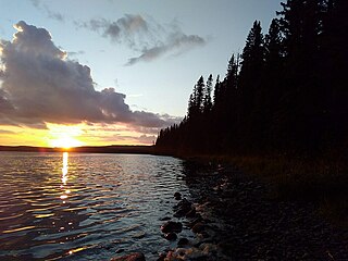
Lake Athapapuskow is a glacial lake in Manitoba and Saskatchewan, Canada, located 15 km (9.3 mi) southeast of Flin Flon, Manitoba. The lake is in the Hudson Bay drainage basin and is the source of the Goose River.
The Thlewiaza River is a river in Canada. Although some sources define the river as originating out of Nueltin Lake, according to the Canadian Geographical Names Database the river begins at Snyder Lake in northwestern Manitoba. From there the river flows northeast through Kasmere Lake into the southwest end of Nueltin Lake. It exits Nueltin Lake at its northern end in Nunavut and flows 275 kilometres (171 mi) east through Edehon Lake and Ranger Seal Lake before emptying into Hudson Bay. Its drainage basin covers an area of 64,399.6 square kilometres (24,864.8 sq mi).
Porcupine Hills Provincial Park is the newest provincial park in the Canadian Province of Saskatchewan. It was created in 2018 through the amalgamation of five pre-existing provincial recreation sites south-east of the town of Hudson Bay. The park is in the Porcupine Provincial Forest in the Porcupine Hills, which is a geographical feature in eastern Saskatchewan and western Manitoba. The hills are part of a range of hills called the Manitoba Escarpment.

