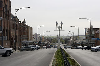
Bathurst is a city in the Central Tablelands of New South Wales, Australia. Bathurst is about 200 kilometres (120 mi) west-northwest of Sydney and is the seat of the Bathurst Regional Council. Founded in 1815, Bathurst is the oldest inland settlement in Australia and had a population of 37,396 in 2021.

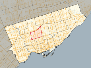
Forest Hill is a neighbourhood and former village in Midtown Toronto, Ontario, Canada, located north of Downtown Toronto. The village was amalgamated into Toronto in 1967 and the area has retained its name as a neighbourhood. Along with other neighbourhoods such as Rosedale and The Bridle Path, it is one of Toronto's wealthiest neighbourhoods, with an average income, among income recipients 15 or older in private households, of $157,600 in Forest Hill South and $89,700 in Forest Hill North, compared to the $59,250 average income in Toronto's Census Metropolitan Area and $54,450 in Canada as a whole.

Bathurst Street is a main north–south arterial road in Toronto, Ontario, Canada. It begins at an intersection of the Queens Quay roadway, just north of the Lake Ontario shoreline. It continues north through Toronto to the Toronto boundary at Steeles Avenue. It is a four-lane thoroughfare throughout Toronto. The roadway continues north into York Region where it is known as York Regional Road 38.

Yanchep is an outer coastal suburb of Perth, Western Australia, 56 kilometres (35 mi) north of the Perth CBD. It is a part of the City of Wanneroo local government area. Originally a small crayfishing settlement, it was developed by entrepreneur Alan Bond in the 1970s and 80s for the 1987 America's Cup. The area covers the urban centre of Yanchep as well as Yanchep National Park in its entirety.

Alkimos is a coastal suburb of Perth, Western Australia, located 42 kilometres (26 mi) north-northwest of Perth's central business district. It is part of the City of Wanneroo local government area.

Eglinton is a locality in the Western Australian capital city of Perth, approximately 44 kilometres (27 mi) north of Perth's central business district on the Indian Ocean. For the most part, the suburb is covered in native banksia woodland, scrubland and heath typical of the Swan Coastal Plain. However, in recent years, there has been growth in residential estates, with a town centre to be built in the near future.

Jindalee is an outer coastal suburb of Perth, Western Australia, located approximately 40 kilometres (25 mi) north of the Perth central business district. Its local government area is the City of Wanneroo.

Kelso is a suburb of Bathurst, New South Wales, Australia, in the Bathurst Regional Council area.

Bathurst is an electoral district of the Legislative Assembly in the Australian state of New South Wales. It is represented by Paul Toole of the Nationals.

Lawrence Manor is a neighbourhood in the city of Toronto, Ontario, Canada. This neighbourhood is bounded by Bathurst Street on the east, Highway 401 to the north, the Allen to the west, and Lawrence Avenue to the south. The western side of the area borders along Bathurst Heights and the large public housing project.
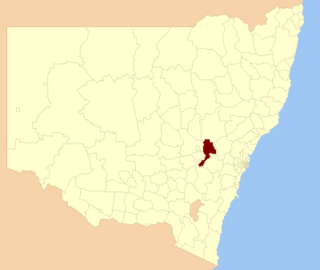
Bathurst Regional Council is a local government area in the Central West region of New South Wales, Australia. The area is located adjacent to the Great Western Highway, Mid-Western Highway, Mitchell Highway and the Main Western railway line. At the 2021 census, the Bathurst Region had a population of 43,567.

Vaughan Road is a road in Toronto, Ontario, Canada. It is a contour collector road that is parallel to a buried creek to the north called Castle Frank Brook. Vaughan Road begins on Bathurst Street south of St. Clair Avenue West, then it becomes a north–south street, hence its address numbering system, then it becomes a northwest–southeast street. Finally, Vaughan Road ends in a dead-end near Fairbank station at the intersection of Eglinton Avenue and Dufferin Street. Vaughan Road Academy is named after this road.
Eglinton—Lawrence is a provincial electoral district in Toronto, Ontario, Canada. It elects one member to the Legislative Assembly of Ontario.
West Bathurst is a suburb of Bathurst in the Bathurst Region, New South Wales, Australia.

Forest Hill is an underground light rail transit (LRT) station under construction on Line 5 Eglinton, a new line that is part of the Toronto subway system. It will be located in the Forest Hill neighbourhood at the intersection of Bathurst Street and Eglinton Avenue. It is scheduled to open no earlier than 2024.
Mount Panorama is a suburb of Bathurst, New South Wales, Australia, in the Bathurst Region. The suburb of Mount Panorama is the site of the Mount Panorama Circuit a street racing track.
South Bathurst is a suburb of Bathurst, New South Wales, Australia, in the Bathurst Region.
Mitchell is a suburb of Bathurst, New South Wales, Australia, in the Bathurst Region.
Robin Hill is a suburb of Bathurst, New South Wales, Australia, in the Bathurst Region.

