
Macquarie Pass National Park is a national park in New South Wales, Australia, 90 km southwest of Sydney. It is located around the pass of the same name, which is on the Illawarra Highway and part of the Illawarra escarpment.
Blackburn South is a suburb of Melbourne, Victoria, Australia, 16 km east of Melbourne's Central Business District, located within the City of Whitehorse local government area. Blackburn South recorded a population of 10,939 at the 2021 census.
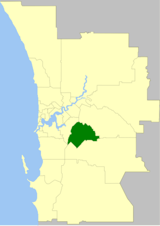
The City of Gosnells is a local government area in the southeastern suburbs of the Western Australian capital city of Perth, located northwest of Armadale and about 20 kilometres (12 mi) southeast of Perth's central business district. The City covers an area of 128 square kilometres (49.42 sq mi), a portion of which is state forest rising into the Darling Scarp to the east, and had a population of approximately 118,000 at the 2016 Census. The largest activity centre in the City is the Central Maddington shopping centre. District centres exist in the Gosnells town centre and Thornlie.

Peppermint Grove is an affluent western suburb of Perth, Western Australia on the north bank of the Swan River at Freshwater Bay. Its local government area, the smallest in the country, is the Shire of Peppermint Grove. The suburb was named after the Swan River peppermint trees lining many streets. The suburb has long been associated with Western Australia's wealthiest and oldest families. Their prosperity is reflected in the many historical houses in the area, such as The Cliffe and the Federation Queen Anne style St Just. Colin Barnett, a former Premier of Western Australia, dubbed the suburb "Monaco of WA" due to its small size and concentration of wealth. It is also known as millionaire’s row and had the highest income of any suburb in Australia in 2022.

The Shire of Augusta Margaret River is a local government area in the south-west corner of the South West region of Western Australia, approximately 270 kilometres (168 mi) south of Perth. The shire covers an area of 2,243 square kilometres (866 sq mi) and had a population of over 14,000 at the 2016 Census, about half of whom live in the towns of Margaret River and Augusta.

Carcoar is a small town in the Central West region of New South Wales, Australia, in Blayney Shire. In 2021, the town had a population of 271 people. It is situated just off the Mid-Western Highway 258 km west of Sydney and 52 km south-west of Bathurst and is 720 m above sea level. It is located in a small green valley, with the township and buildings on both banks of the Belubula River. It is the third oldest settlement west of the Blue Mountains. Carcoar is a Gundungurra word meaning either 'frog' or 'kookaburra'. Nearby towns are Blayney, Millthorpe, Mandurama, Neville, Lyndhurst and Barry

Bigga is a village in the Southern Tablelands of New South Wales, Australia, in Upper Lachlan Shire. It is in the Parish of Bigga, County of Georgiana. The name Bigga is thought to originate as a shortened version of the Biggs Grant. Bigga is on the western side of the Abercrombie Mountains. It is 91 km northwest of Goulburn and 52 km southeast of Cowra. Nearby towns are: Abercrombie River, Binda, Greenmantle, Grabine, Reids Flat, and Tuena. Nearby places are: Blanket Flat and Crooked Corner. These places were once towns.

The City of Kalamunda is a local government area in the eastern metropolitan region of the Western Australian capital city of Perth about 25 kilometres (16 mi) east of Perth's central business district. The area covers 324 square kilometres (125 sq mi), much of which is state forest rising into the Darling Scarp to the east. As of 2021, the city had a population of 58,762.
Ellen Grove is an outer south-western suburb in the City of Brisbane, Queensland, Australia. In the 2021 census, Ellen Grove had a population of 3,586 people.

Carole Park is an industrial suburb in the City of Ipswich, Queensland, Australia. In the 2021 census, Carole Park had a population of 8 people.

The City of Armadale is a local government area in the southeastern suburbs of the Western Australian capital city of Perth, about 28 kilometres (17.4 mi) southeast of Perth's central business district. The City covers an area of 560 square kilometres (216 sq mi), much of which is state forest rising into the Darling Scarp to the east, and had a population of almost 80,000 as at the 2016 Census. At the 2021 census, the population had risen to 94,184.

The Shire of Capel is a local government area in the South West region of Western Australia, taking in the land between the cities of Bunbury and Busselton about 200 kilometres (124 mi) south of the state capital, Perth. The Shire covers an area of 557.6 square kilometres (215.3 sq mi), and its seat of government is the town of Capel.

The Tiwi Islands Region is a local government area (LGA) of the Northern Territory, Australia. The LGA covers an area of 7,483 square kilometres (2,889 sq mi) and had an estimated population of 2,753 in June 2018, and is governed by the Tiwi Islands Regional Council, formerly Tiwi Islands Shire Council.
Palm Grove is a suburb of the Central Coast region of New South Wales, Australia. It is located about 10 kilometres (6 mi) upstream along Ourimbah Creek from the town of Ourimbah. It is part of the Central Coast Council local government area.

Tuena is a town in the Southern Tablelands of New South Wales, Australia, in Upper Lachlan Shire. It is located on Tuena Creek, tributary of the Abercrombie River, 269 km (167 mi) west of the state capital, Sydney. At the 2016 census, Tuena and the surrounding area had a population of 59.
Little Grove is a suburb of Albany, Western Australia.
Peel is a locality in the Bathurst Region of New South Wales, Australia. It had a population of 290 people as of the 2016 census.

The 2022 Supercars Championship was a motor racing series for Supercars. It was the twenty-fourth running of the Supercars Championship and the twenty-sixth series in which Supercars have contested the Australian Touring Car Championship, the premier title in Australian motorsport.
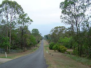
Forest Grove is a locality in the South West region of Western Australia in the Shire of Augusta-Margaret River.
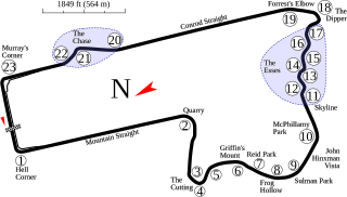
The 2022 Bathurst 1000 was a motor racing event for Supercars held on the week of 6 to 9 October 2022. It hosted the eleventh round of the 2022 Supercars Championship. It took place at the Mount Panorama Circuit in Bathurst, New South Wales, Australia and featured a single 1000 kilometre race.

