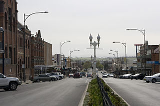
Bathurst is a city in the Central Tablelands of New South Wales, Australia. Bathurst is about 200 kilometres (120 mi) west-northwest of Sydney and is the seat of the Bathurst Regional Council. Bathurst is the oldest inland settlement in Australia and had a population of 37,191 in June 2019.

Bigga is a village in the Southern Tablelands of New South Wales, Australia, in Upper Lachlan Shire. It is in the Parish of Bigga, County of Georgiana. The name Bigga is thought to originate as a shortened version of the Biggs Grant. Bigga is on the western side of the Abercrombie Mountains. It is 91 km northwest of Goulburn and 52 km southeast of Cowra. Nearby towns are: Abercrombie River, Binda, Greenmantle, Grabine, Reids Flat, and Tuena. Nearby places are: Blanket Flat and Crooked Corner. These places were once towns.
Holroyd is a small suburb in western Sydney, New South Wales, Australia. Holroyd is located 20 kilometres (12 mi) west of the Sydney central business district in the local government area of the Cumberland Council. The previous local government area of Holroyd City took its name from Arthur Holroyd, first Mayor of the area, local landowner and businessman. The administrative centre is located in nearby Merrylands.

Pitt Town is a historic town and suburb of Sydney, in the state of New South Wales, Australia. Pitt Town is 59 kilometres north-west of the Sydney central business district in the local government area of the City of Hawkesbury. It is bounded in the north by the Hawkesbury River.

Kelso is a suburb of Bathurst, New South Wales, Australia, in the Bathurst Regional Council area.

Bathurst is an electoral district of the Legislative Assembly in the Australian state of New South Wales. It is represented by Paul Toole of The Nationals.
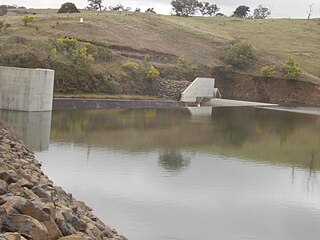
Ben Chifley Dam, or Chifley Dam, is a rock and earth-fill embankment dam across the Campbells River in the central west region of New South Wales, Australia. The main purpose of the dam is to supply potable water to the city of Bathurst.
West Bathurst is a suburb of Bathurst in the Bathurst Region, New South Wales, Australia.
Perthville is a small town in New South Wales, Australia. The town is located on the Central Tablelands, approximately 10 kilometres (6.2 mi) from the regional city of Bathurst. The town has evolved over time due to road improvements to be a satellite suburb of Bathurst.
Eglinton is a northern suburb of Bathurst, New South Wales, Australia, in the Bathurst Region.

Llanarth is a locality in the Bathurst Region of New South Wales, Australia, approximately 3 kilometres (1.9 mi) from Bathurst. It was named after the historic Llanarth property, established in 1858 by the Smith family after their previous home of Llanarth in Cornwall. It had a population of 2,198 people as of the 2016 census.
Raglan is a locality in the Bathurst Region of New South Wales, Australia. It was named after FitzRoy Somerset, 1st Baron Raglan, commander-in-chief of the Allied forces in the Crimean War from 1850 to 1855. It had a population of 1,199 people as of the 2016 census.
Mount Panorama is a suburb of Bathurst, New South Wales, Australia, in the Bathurst Region.
Mitchell is a suburb of Bathurst, New South Wales, Australia, in the Bathurst Region.
Robin Hill is a suburb of Bathurst, New South Wales, Australia, in the Bathurst Region.
Forest Grove is a suburb of Bathurst, New South Wales, Australia, in the Bathurst Region.
Gormans Hill is a suburb of Bathurst, New South Wales, Australia, in the Bathurst Region.
Windradyne is a suburb of Bathurst, New South Wales, Australia, in the Bathurst Region.

Vittoria is a locality in the Bathurst Region of New South Wales, Australia. It had a population of 62 people as of the 2016 census.
Meadow Flat is a locality in the Bathurst Region and City of Lithgow of New South Wales, Australia. It had a population of 309 people as of the 2016 census.
