
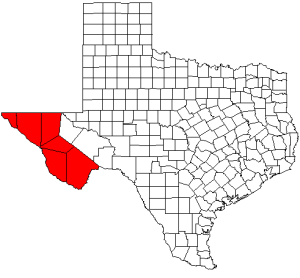
El Paso County is the westernmost county in the U.S. state of Texas. As of the 2020 census, the population was 865,657, making it the ninth-most populous county in the state of Texas. Its seat is the city of El Paso, the sixth-most populous city in Texas and the 22nd-most populous city in the United States. The county was created in 1850 and later organized in 1871.
Anthony is a city in Doña Ana County, New Mexico, United States. The population was 8,693 at the 2020 census. It is located on the New Mexico–Texas state line in the Upper Mesilla Valley, and on Interstate 10, 24 miles south of Las Cruces and 18 miles north of El Paso, Texas.

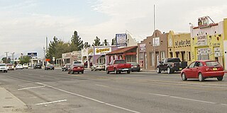
Chaparral is an unincorporated community and census-designated place (CDP) in Doña Ana and Otero counties, New Mexico. The population was 14,631 at the 2010 census. Chaparral is primarily a bedroom community for the neighboring city of El Paso, Texas, and the neighboring military installations of White Sands Missile Range and Fort Bliss. It is officially part of the Las Cruces Metropolitan Statistical Area.

Doña Ana is a census-designated place (CDP) in Doña Ana County, New Mexico, United States. The population was 1,211 at the 2010 census.

Hatch is a village in Doña Ana County, New Mexico, United States. The population was 1,648 at the 2010 census. The town is experiencing moderate growth, along with its outliers of Salem, Arrey, Derry, and Rincon. Hatch is widely known as the "best chile place in the World," for growing a wide variety of peppers, especially the New Mexican cuisine staple, and one of New Mexico's state vegetables, the New Mexico chile.

Las Cruces is the second-most populous city in the U.S. state of New Mexico and the seat of Doña Ana County. As of the 2020 census the population was 111,385, making Las Cruces the most populous city in both Doña Ana County and southern New Mexico. The Las Cruces metropolitan area had an estimated population of 213,849 in 2017. It is the principal city of a metropolitan statistical area which encompasses all of Doña Ana County and is part of the larger El Paso–Las Cruces combined statistical area with a population of 1,088,420 making it the 56th largest combined statistical area in the United States.

Mesquite is an unincorporated community and census-designated place (CDP) in Doña Ana County, New Mexico, United States. The population was 1,112 at the 2010 census, up from 948 at the 2000 census. It is part of the Las Cruces Metropolitan Statistical Area.

Santa Teresa is a census-designated place (CDP) in Dona Ana County, New Mexico, United States. It is home to the Santa Teresa Port of Entry and is part of the Las Cruces Metropolitan Statistical Area, although geographically it is considerably closer to El Paso, Texas, than to Las Cruces. While the United States Census Bureau has defined Santa Teresa as a CDP, the census definition of the area may not precisely correspond to local understanding of the area with the same name. The population was 4,258 at the 2010 census and 5,044 at the 2020 census. The National Weather Service El Paso Weather Forecast Office that serves extreme western Texas and Southwestern New Mexico states is based in Santa Teresa.
Sunland Park is a city in southeastern Doña Ana County, New Mexico, United States, on the borders of Texas and the Mexican state of Chihuahua, with Ciudad Juárez adjoining it on the south and El Paso, Texas, on the east. The community of Santa Teresa adjoins it on the northwest. The population of Sunland Park was 14,106 at the 2010 census and was estimated at 17,978 by the United States Census Bureau in 2019. Though it lies adjacent to El Paso, being in Doña Ana County makes it a part of the Las Cruces metropolitan statistical area. Las Cruces is 42 miles (68 km) to the north.

Vado is an unincorporated community and census-designated place (CDP) in Doña Ana County, New Mexico, United States. The population was 3,194 at the 2010 census. The ZIP code for Vado is 88072, its area code is 575, and it is part of the Las Cruces Metropolitan Statistical Area.
The Rio Grande Council of Governments (RGCOG) is a voluntary association of cities, counties and special districts in West Texas and Doña Ana County, New Mexico

The Albuquerque–Santa Fe–Los Alamos combined statistical area is made up of eight counties in north central New Mexico. The combined statistical area consists of the Albuquerque and Santa Fe metropolitan statistical areas, and the Las Vegas, Los Alamos, and Española micropolitan statistical areas. The 2013 delineations included the Grants micropolitan statistical area, but it was removed in the 2018 revisions. As of the 2020 census, the CSA had a population of 1,162,523. Roughly 56% of New Mexico's residents live in this area. Prior to the 2013 redefinitions, the CSA consisted only of the Santa Fe metropolitan statistical area and the Española micropolitan statistical area. The total land area of the Albuquerque–Santa Fe–Las Vegas combined statistical area in the 2013 definition is 26,421 sq mi (68,430 km2).

U.S. Highway 85 or US 85 is a route in the system of United States Numbered Highways maintained by the Texas Department of Transportation (TxDOT). The Texas portion of US 85 is located entirely within El Paso County beginning at the U.S.-Mexico border between the city of El Paso and Ciudad Juárez, Chihuahua. The approximately 20-mile (32 km) route briefly overlays US 62 in downtown El Paso, then traverses north along the city's west side before merging with the combined route of Interstate 10 and US 180. The route then follows I-10 and US 180 through the towns of Vinton and Anthony before crossing the New Mexico state line into the town of Anthony, New Mexico, in Doña Ana County.

The El Paso metropolitan area, officially the El Paso metropolitan statistical area, as defined by the United States Census Bureau, is an area consisting of two counties – El Paso and Hudspeth – in far West Texas, anchored by the city of El Paso. As of the 2020 United States census, the MSA had a population of 868,859. The El Paso MSA forms part of the larger El Paso–Las Cruces combined statistical area, with a total population of 1,088,420 as of the 2020 United States Census.

El Paso–Juárez, also known as Juárez–El Paso, the Borderplex or Paso del Norte, is a transborder agglomeration, on the border between Mexico and the United States. The region is centered on two large cities: Ciudad Juárez, Chihuahua, Mexico, and El Paso, Texas, U.S. Additionally, nearby Las Cruces, New Mexico, U.S., is sometimes included as part of the region, referred to as El Paso–Juárez–Las Cruces or El Paso–Juárez–Southern New Mexico. With over 2.7 million people, this binational region is the 2nd largest conurbation on the United States–Mexico border. The El Paso–Juárez region is the largest bilingual, binational work force in the Western Hemisphere.

Doña Ana County is a county located in the southern part of the New Mexico, United States. As of the 2020 U.S. Census, its population was 219,561, which makes it the second-most populated county in New Mexico. Its county seat is Las Cruces, the second-most populous municipality in New Mexico after Albuquerque, with 111,385 as of the 2020 U.S. Census.
La Union is a census-designated place in Doña Ana County, New Mexico, United States. Its population was 1,106 as of the 2010 census. NM 182 connects the community to NM 28. It is a part of the El Paso–Las Cruces combined statistical area.
The Elephant Butte Irrigation District is a 6,870 acres (27.8 km2) historic district in New Mexico and Texas which was listed on the National Register of Historic Places in 1997. The listing included three contributing buildings and 214 contributing structures, in Doña Ana County, New Mexico, Sierra County, New Mexico and El Paso County, Texas.
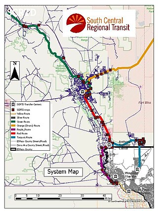
The South Central Regional Transit District operates a network of several local and intercity bus routes in southern New Mexico, serving Las Cruces, Alamogordo, Hatch/Garfield, Anthony, and Sunland Park, with three connections to El Paso, Texas, as well as serving many smaller communities along a network of eight fixed routes. Routes operate Monday through Friday, except the Yellow Line servicing Sunland Park, which operates Monday through Saturday. All routes cost $1 for adults, and $0.50 for children, seniors, students, and people with disabilities. Bus transfers between SCRTD buses are free. The service is supported primarily by federal grants and local funding from membership fees and Doña Ana County funding agreement for services.

