Vinton, Texas

Last updated

Vinton, Texas
TXMap-doton-Vinton.PNG
Location of Vinton, Texas
ElPaso County Vinton.svg
Coordinates: 31°57′34″N106°35′37″W / 31.95944°N 106.59361°W / 31.95944; -106.59361
Country United States
State Texas
County El Paso
Incorporated1961 [1]
Government
  TypeMayor-council
Area
[2]
  Total2.74 sq mi (7.10 km2)
  Land2.74 sq mi (7.10 km2)
  Water0.00 sq mi (0.00 km2)
Elevation
[3]
3,839 ft (1,170 m)
Population
 (2020)
  Total2,684
  Density980/sq mi (380/km2)
Time zone UTC-7 (Mountain (MST))
  Summer (DST) UTC-6 (MDT)
ZIP code
79821
Area code 915
FIPS code 48-75668 [4]
GNIS feature ID2413596 [3]
Website www.vintontx.govoffice2.com

Vinton is a village in El Paso County, Texas, United States. The population was 2,684 at the 2020 census. It is part of the El Paso Metropolitan Statistical Area.

Contents

History

Native Americans inhabited the site of Vinton before the arrival of the Spaniards, who made it a stopping place along the Camino Real, the road from El Paso to Santa Fe, which passed along the east bank of the Rio Grande through what is now Vinton. In Spanish and Mexican colonial times, it was known as La Salinera, from the salt cedars which grew there in abundance; when the area passed to the United States after the US-Mexican War, this water stop became known as Cottonwood, and was located in the northern part of Vinton along the river, 22 miles from El Paso. In 1857, it was used by the San Antonio-San Diego Mail Line and from 1858 to 1861 by the Butterfield Overland Mail, that had a stage station called Cottonwood Station, located 22 miles from El Paso and 25 miles from Fort Fillmore up river in New Mexico. [5] [6] [7]

Vinton was named for Southern Pacific Railroad surveyor John C. Vinton, who laid the cross-country route for the railroad through the area in 1881, and was most likely established around that time. A post office was opened there in 1892, and the town grew slowly in the next 100 years, reaching 605 in 1990, then tripling in population in the following decade to 1892 in the 2000 census. The incorporation of Vinton as Village of Industry on August 8, 1961 [8] originated with Border Steel Corporation, which opened a mill in town that year; now owned by Arcelor Mittal, it is still in operation. [7] [9]

Geography

According to the United States Census Bureau, the village has a total area of 2.4 square miles (6.2 km2), all land.

Demographics

Historical population
CensusPop.Note
1980 372
1990 60562.6%
2000 1,892212.7%
2010 1,9714.2%
2020 2,68436.2%
U.S. Decennial Census [10]

2020 Census data

Vinton racial composition [11]
(NH = Non-Hispanic) [lower-alpha 1]
RaceNumberPercentage
White (NH)36313.52%
Black or African American (NH)702.61%
Native American or Alaska Native (NH)632.35%
Asian (NH)200.75%
Pacific Islander (NH)20.07%
Some Other Race (NH)60.22%
Mixed/Multi-Racial (NH)90.34%
Hispanic or Latino 2,15180.14%
Total2,684

As of the 2020 United States census, there were 2,684 people, 432 households, and 379 families residing in the village.

2000 Census data

As of the census [4] of 2000, there were 1,892 people, 496 households, and 431 families residing in the village. The population density was 779.9 inhabitants per square mile (301.1/km2). There were 520 housing units at an average density of 214.4 per square mile (82.8/km2). The racial makeup of the village was 80.44% White, 1.00% African American, 0.16% Native American, 0.11% Asian, 15.59% from other races, and 2.70% from two or more races. Hispanic or Latino of any race were 93.60% of the population.

There were 496 households, out of which 67.1% had children under the age of 18 living with them, 66.7% were married couples living together, 13.9% had a female householder with no husband present, and 13.1% were non-families. 11.9% of all households were made up of individuals, and 4.0% had someone living alone who was 65 years of age or older. The average household size was 3.81 and the average family size was 4.13.

In the village, the population was spread out, with 43.0% under the age of 18, 9.8% from 18 to 24, 31.5% from 25 to 44, 12.7% from 45 to 64, and 3.0% who were 65 years of age or older. The median age was 23 years. For every 100 females, there were 101.9 males. For every 100 females age 18 and over, there were 95.8 males. The median income for a household in the village was $26,779, and the median income for a family was $27,240. Males had a median income of $22,955 versus $14,777 for females. The per capita income for the village was $9,974. About 25.2% of families and 30.4% of the population were below the poverty line, including 31.6% of those under age 18 and 32.8% of those age 65 or over.

Education

Almost all of Vinton is served by the Canutillo Independent School District, while a small section is in the Anthony Independent School District. [14] Childress Elementary School is located in the village, [15] and it is zoned to Childress for pre-kindergarten to fifth grades, [16] and Canutillo Middle School for sixth to eighth grades. [17] High-school students attend Canutillo High School and may also attend Northwest Early College High School should they qualify for admission.

Related Research Articles

<span class="mw-page-title-main">Midland County, Texas</span> County in Texas, United States

Midland County is a county located in the U.S. state of Texas. As of 2020, the population was 169,983. The county seat is Midland. The county is so named for being halfway (midway) between Fort Worth and El Paso on the Texas and Pacific Railway. Midland County is included in the Midland, TX Metropolitan Statistical Area as well as the Midland–Odessa Combined Statistical Area.

<span class="mw-page-title-main">Matagorda County, Texas</span> County in Texas, United States

Matagorda County is a county located in the U.S. state of Texas. As of the 2020 census, the population was 36,255. Its county seat is Bay City, not to be confused with the larger Baytown in Harris and Chambers Counties. Matagorda County is named for the canebrakes that once grew along the coast.

<span class="mw-page-title-main">El Paso County, Texas</span> County in Texas, United States

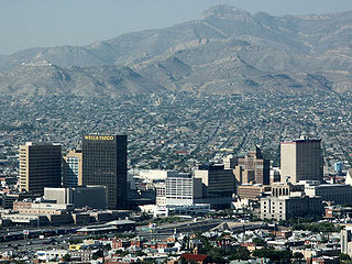
El Paso County is the westernmost county in the U.S. state of Texas. As of the 2020 census, the population was 865,657, making it the ninth-most populous county in the state of Texas. Its seat is the city of El Paso, the sixth-most populous city in Texas and the 22nd-most populous city in the United States. The county was created in 1850 and later organized in 1871.

<span class="mw-page-title-main">Childress County, Texas</span> County in Texas, United States

Childress County is a county located in the U.S. state of Texas. As of the 2020 census, its population was 6,664. The county seat is Childress. The county was created in 1876 and later organized in 1887. It is named for George Campbell Childress, the author of the Texas Declaration of Independence.

<span class="mw-page-title-main">Santa Teresa, New Mexico</span> Census-designated place in Doña Ana County, New Mexico, United States

Santa Teresa is a census-designated place (CDP) in Dona Ana County, New Mexico, United States. It is home to the Santa Teresa Port of Entry and is part of the Las Cruces Metropolitan Statistical Area, although geographically it is considerably closer to El Paso, Texas than to Las Cruces. While the United States Census Bureau has defined Santa Teresa as a CDP, the census definition of the area may not precisely correspond to local understanding of the area with the same name. The population was 4,258 at the 2010 census and 5,044 at the 2020 census. The National Weather Service El Paso Weather Forecast Office that serves extreme western Texas and Southwestern New Mexico states is based in Santa Teresa.

<span class="mw-page-title-main">Agua Dulce, El Paso County, Texas</span> Census-designated place in Texas, United States

Agua Dulce is a census-designated place (CDP) in El Paso County, Texas, United States. The population was 3,218 at the 2020 census. It is part of the El Paso Metropolitan Statistical Area. The ZIP Code encompassing the CDP area is 79928.

<span class="mw-page-title-main">Canutillo, Texas</span> Census-designated place in Texas, United States

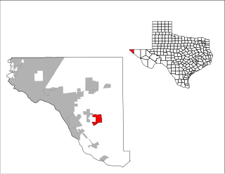
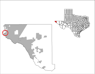
Canutillo is a census-designated place (CDP) in El Paso County, Texas, United States. The population was 6,321 at the 2010 census. It is part of the El Paso Metropolitan Statistical Area. The ZIP Codes encompassing the CDP area are 79835 and 79932.

<span class="mw-page-title-main">Homestead Meadows North, Texas</span> Census-designated place in Texas, United States

Homestead Meadows North is a census-designated place (CDP) in El Paso County, Texas, United States. The population was 5,124 at the 2010 census. It is part of the El Paso Metropolitan Statistical Area. The ZIP Code encompassing the CDP area is 79938.

<span class="mw-page-title-main">Homestead Meadows South, Texas</span> Census-designated place in Texas, United States

Homestead Meadows South is a census-designated place (CDP) in El Paso County, Texas, United States. The population was 7,247 at the 2010 census. It is part of the El Paso Metropolitan Statistical Area. The ZIP Code encompassing the CDP area is 79938.

<span class="mw-page-title-main">Morning Glory, Texas</span> Census-designated place in Texas, United States

Morning Glory is a census-designated place (CDP) in El Paso County, Texas, United States. The population was 522 at the 2020 census, down from 651 at the 2010 census. It is part of the El Paso Metropolitan Statistical Area. The ZIP Code encompassing the CDP area is 79836.

<span class="mw-page-title-main">Prado Verde, Texas</span> Census-designated place in Texas, United States

Prado Verde is a census-designated place (CDP) in El Paso County, Texas, United States. The population is 246 according to the 2010 census. It is part of the El Paso Metropolitan Statistical Area. The ZIP Code encompassing the CDP area is 79932.

<span class="mw-page-title-main">Sparks, Texas</span> Census-designated place in Texas, United States

Sparks is a census-designated place (CDP) in El Paso County, Texas, United States. The population was 4,529 at the 2010 census. It is part of the El Paso Metropolitan Statistical Area. The ZIP Code encompassing the CDP area is 79928.

<span class="mw-page-title-main">Tornillo, Texas</span> Place in Texas, United States

Tornillo is a border town in El Paso County, Texas, United States. The population was 1,568 at the 2010 census. For statistical purposes, the United States Census Bureau has defined this unincorporated community as a census-designated place (CDP). It is part of the El Paso Metropolitan Statistical Area. The Tornillo and Guadalupe, Chihuahua, area is connected by the Tornillo–Guadalupe International Bridge.

<span class="mw-page-title-main">Westway, Texas</span> Census-designated place in Texas, United States

Westway is a census-designated place (CDP) in El Paso County, Texas, United States. The population was 4,188 at the 2010 census. It is part of the El Paso Metropolitan Statistical Area. It is located east of Interstate 10, approximately 2 miles (3 km) from the New Mexico - Texas state line. The ZIP Code encompassing the CDP area is 79835.

<span class="mw-page-title-main">El Lago, Texas</span> City in Harris County, Texas, United States

El Lago is a city in Harris County, Texas, United States. The population was 3,090 at the 2020 census.

<span class="mw-page-title-main">Fort Davis, Texas</span> Census-designated place in Texas, United States

Fort Davis is an unincorporated community and census-designated place (CDP) in Jeff Davis County, Texas, United States. The population was 1,201 at the 2010 census, up from 1,050 at the 2000 census. It is the county seat of Jeff Davis County.

<span class="mw-page-title-main">Seven Oaks, Texas</span> City in Texas, United States

Seven Oaks is a city in Polk County, Texas, United States. The population was 68 at the 2020 census.

<span class="mw-page-title-main">Falcon Village, Texas</span> CDP in Texas, United States

Falcon Village is a census-designated place (CDP) in Starr County, Texas, United States. The population was 3 at the 2020 census.

<span class="mw-page-title-main">Las Lomas, Texas</span> CDP in Texas, United States

Las Lomas is a census-designated place (CDP) in Starr County, Texas, United States. The population was 3,147 at the 2010 census. Las Lomas is one of several colonias in Starr County, within the Rio Grande Valley region. The name is derived from the community's terrain.

<span class="mw-page-title-main">Canutillo Independent School District</span> School district in Texas, United States

Canutillo Independent School District (CISD) is a public school district with its headquarters in El Paso, Texas. Dr. Pedro Galaviz is the Superintendent of Schools.

References

  1. "Vinton Police Department - TEXAS". Archived from the original on October 13, 2020. Retrieved August 1, 2014.
  2. "2019 U.S. Gazetteer Files". United States Census Bureau. Retrieved August 7, 2020.
  3. 1 2 U.S. Geological Survey Geographic Names Information System: Vinton, Texas
  4. 1 2 "U.S. Census website". United States Census Bureau . Retrieved January 31, 2008.
  5. Table of distances from Texas Almanac, 1859, Book, ca. 1859; digital images, (http://texashistory.unt.edu/ark:/67531/metapth123765/ accessed November 12, 2013), University of North Texas Libraries, The Portal to Texas History, http://texashistory.unt.edu; crediting Texas State Historical Association, Denton, Texas
  6. List of Stations from New York Times, October 14 1858, Itinerary of the Route
  7. 1 2 "VILLAGE OF VINTON, EL PASO COUNTY, TEXAS BASE MAP" (PDF). Texas Department of Agriculture Planning and Capacity Building Fund. July 2012. Archived from the original (PDF) on August 8, 2014. Retrieved August 1, 2014.
  8. "Village of Vinton, Texas – Basic Financial Statements For the Year Ended September 30, 2008 and Independent Auditors' Report" (PDF). Archived from the original (PDF) on August 8, 2014. Retrieved August 1, 2014.
  9. "TSHA | Vinton, TX".
  10. "Census of Population and Housing". Census.gov. Retrieved June 4, 2015.
  11. "Explore Census Data". data.census.gov. Retrieved May 19, 2022.
  12. https://www.census.gov/ [ not specific enough to verify ]
  13. "About the Hispanic Population and its Origin". www.census.gov. Retrieved May 18, 2022.
  14. "2020 CENSUS - SCHOOL DISTRICT REFERENCE MAP: El Paso County, TX" (PDF). U.S. Census Bureau . Retrieved June 29, 2022. - Vinton block map
  15. "Home". Bill Childress Elementary School. Retrieved July 4, 2022. 7700 Cap Carter Road, Vinton, TX 79821
  16. "Canutillo ISD Boundary Map" (PDF). Canutillo Independent School District . Retrieved July 4, 2022. - Only indicates elementary zoning.
  17. "CISD 2015 Boundary Map". Canutillo Independent School District . Retrieved July 4, 2022.
  1. Note: the US Census treats Hispanic/Latino as an ethnic category. This table excludes Latinos from the racial categories and assigns them to a separate category. Hispanics/Latinos can be of any race. [12] [13]