Related Research Articles
New England and Macleay was an electoral district of the Legislative Assembly in the Australian state of New South Wales from 1856 to 1859, in the Northern Tablelands region of New England and part of the Mid North Coast region, including the area to the north of the Macleay River. but excluding the area south of the Macleay River which was included in the Counties of Gloucester and Macquarie. To the north was the electorate of Clarence and Darling Downs and to the west the electorate of Liverpool Plains and Gwydir. It elected two members, with voters casting two votes and the first two candidates being elected. It was partly replaced by New England.
Lachlan and Lower Darling was an electoral district of the Legislative Assembly in the Australian state of New South Wales. It existed between 1856 and 1859, and was named after the Lachlan and Darling Rivers. It elected two members simultaneously. In 1859 it was replaced by Lachlan.

Murray is an electoral district in the Australian state of New South Wales.
The Electoral district of City of Sydney was an electorate of the New South Wales Legislative Council.

The Electoral district of County of Camden was an electorate of the New South Wales Legislative Council at a time when some of its members were elected and the balance were appointed by the Governor.

The Electoral district of Pastoral Districts of Clarence and Darling Downs was an electorate of the New South Wales Legislative Council at a time when some of its members were elected and the balance were appointed by the Governor. It was a new electorate created in 1851 by the expansion of the Legislative Council to 54, 18 to be appointed and 36 elected. It included the Clarence Valley and the Darling Downs region, which became part of Queensland on its establishment in 1859.
The Electoral district of Sydney Hamlets was an electorate of the New South Wales Legislative Council at a time when some of its members were elected and the balance were appointed by the Governor. It was a new electorate created in 1851 by the expansion of the Legislative Council to 54 members, with 18 to be appointed and 36 elected. The electoral district included what were then outer suburbs of Sydney and are now the inner suburbs of Glebe, Camperdown, O'Connell Town, Chippendale, Redfern, Surry Hills, Paddington, St Leonards and Balmain.
This is a list of members of the New South Wales Legislative Council from 1851 to 1856. The 1851 Electoral Act increased the number of members in the Council to 54, 18 to be appointed and 36 elected. The initial appointments were made in October 1851.</ref> The Speaker was Charles Nicholson.
The Electoral district of Stanley Boroughs was an electorate of the New South Wales Legislative Council at a time when some of its members were elected and the balance were appointed by the Governor. It was a new electorate created in 1851 by the expansion of the Legislative Council to 54 members, with 18 to be appointed and 36 elected. The previous district of Counties of Gloucester, Macquarie, and Stanley was split into the districts of Gloucester & Macquarie, Stanley and Stanley Boroughs. The district included North Brisbane, South Brisbane, Kangaroo Point and Ipswich.

The Electoral district of Counties of Gloucester, Macquarie, and Stanley and from 1851, Gloucester and Macquarie, was an electorate of the partially elected New South Wales Legislative Council, created for the first elections for the Council in 1843. The counties of Gloucester and Macquarie were the settled coastal areas north of Northumberland County, while the County of Stanley was the area surrounding Brisbane, in what became part of Queensland after its separation in 1859. Polling took place at Raymond Terrace, Port Macquarie, Dungog, Stroud, Brisbane, Ipswich and Mr Rowley's residence on the Manning River. The County of Stanley was removed from the district with the expansion of the Council in 1851 and became the districts of County of Stanley and Stanley Boroughs.
The 1856 New South Wales colonial election was to return 54 members of Legislative Assembly composed of 34 electoral districts with 18 returning 1 member, 13 returning 2 members, two returning 3 members and one returning 4 members, all with a first past the post system. In multi-member districts, because each voter could cast more than one vote, it is not possible to total the votes to show the number of voters and voter turnout in these districts is estimated. 8 members from 6 districts were returned unopposed.
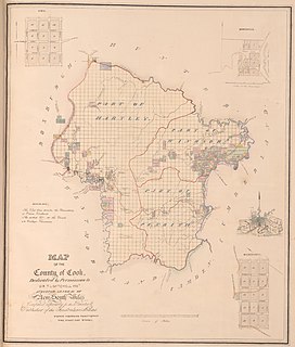
The Electoral district of Counties of Cook and Westmoreland, also known as the United Midland Counties of Cook and Westmoreland, was an electorate of the New South Wales Legislative Council at a time when some of its members were elected and the balance were appointed by the Governor.
The Electoral district of Cumberland Boroughs, also known as the United towns of Windsor, Richmond, Liverpool and Campbelltown, was an electorate of the New South Wales Legislative Council at a time when two thirds were elected, one sixth were official members, that is they held a government office and the balance were appointed by the Governor.
The 1851 New South Wales colonial election, was held between 12 and 25 September. It involved a re-distribution of electorates as a result of the separation of Victoria, which had 6 seats in the previous council, and the expansion of the council from 24 elected members to 36 elected members representing 31 electorates. The major changes were the addition of 8 pastoral districts and the separate representation for the northern regions of what would later become Queensland. These had previously been a part of the single district of Gloucester, Macquarie, and Stanley and from 1851 were covered by the separate districts of Stanley, Stanley Boroughs and the pastoral districts of Moreton, Wide Bay, Burnett, and Maranoa. The other 8 additional seats were distributed among the nineteen counties of New South Wales.
The Electoral district of Pastoral Districts of Liverpool Plains and Gwydir was an electorate of the New South Wales Legislative Council at a time when some of its members were elected and the balance were appointed by the Governor. It was a new electorate created in 1851 by the expansion of the Legislative Council to 54, 18 to be appointed and 36 elected. The district was named after the Liverpool Plains and Gwydir River and covered what is now known as the North West Slopes region. On its eastern side was the Pastoral Districts of New England and Macleay and to the south was the Pastoral Districts of Wellington and Bligh. Polling was to occur in the towns of Murrurundi, Tamworth, Wee Waa, Warialda and the Woolshed on the Namoi River.
The Electoral district of Pastoral District of Maneroo was an electorate of the New South Wales Legislative Council at a time when some of its members were elected and the balance were appointed by the Governor. It was a new electorate created in 1851 by the expansion of the Legislative Council to 54, 18 to be appointed and 36 elected. The district covered the Maneroo region now known as Monaro in the south east of New South Wales. To its north was the Electoral district of Counties of Murray and St Vincent. Polling was to occur in the towns of Goulburn, Eden, Cooma and Bombala.
The Electoral district of Pastoral District of Murrumbidgee was an electorate of the New South Wales Legislative Council at a time when some of its members were elected and the balance were appointed by the Governor. It was a new electorate created in 1851 by the expansion of the Legislative Council to 54, 18 to be appointed and 36 elected. The district is located in the west of the state and was named after the Murrumbidgee River. Polling was to occur in the towns of Tumut, Gundagai, Albury, Wagga Wagga, Moulamein and Yass.
The Electoral district of Pastoral Districts of New England and Macleay was an electorate of the New South Wales Legislative Council at a time when some of its members were elected and the balance were appointed by the Governor. It was a new electorate created in 1851 by the expansion of the Legislative Council to 54, 18 to be appointed and 36 elected. The district is located in the north of the state and covered the Northern Tablelands region of New England and part of the Mid North Coast region, including the area to the north of the Macleay River, but excluding the area south of the Macleay River which was included in the Counties of Gloucester and Macquarie. To the north was the Pastoral Districts of Clarence and Darling Downs and to the west the Pastoral Districts of Liverpool Plains and Gwydir. Polling took place in the towns of Wellingrove, Armidale, Tenterfield, Walcha and Kempsey.
The Electoral district of Pastoral Districts of Wellington and Bligh was an electorate of the New South Wales Legislative Council at a time when some of its members were elected and the balance were appointed by the Governor. It was a new electorate created in 1851 by the expansion of the Legislative Council to 54, 18 to be appointed and 36 elected. The district was located in the central west region of the state and covered the pastoral areas to the west of the Counties of Roxburgh and Wellington and Counties of Phillip, Brisbane and Bligh. To the north was the Pastoral Districts of Liverpool Plains and Gwydir and to the south the Pastoral Districts of Lachlan and Lower Darling. If polling had been required, it would have taken place in the towns of Molong, Wellington, Dubbo, Canowindra, Coola and Mudgee.
The Electoral district of Pastoral Districts of Moreton, Wide Bay, Burnett, and Maranoa was an electorate of the New South Wales Legislative Council at a time when some of its members were elected and the balance were appointed by the Governor. It was a new electorate created in 1851 by the expansion of the Legislative Council to 54, 18 to be appointed and 36 elected. The district was named after the early settlements of Moreton Bay; Wide Bay, near Maryborough; the Burnett River, near Bundaberg; the Maranoa region of South-western Queensland. These became part of Queensland on its establishment in 1859.
References
- 1 2 "An Act to provide for the division of the Colony of New South Wales after the separation of the District of Port Phillip therefrom into Electoral Districts and for the Election of Members to serve in the Legislative Council.". Act No. 48 of 2 May 1851 (PDF). Australasian Legal Information Institute. Retrieved 10 September 2014.
- ↑ "Sir William Macarthur (1800-1882)". Former members of the Parliament of New South Wales . Retrieved 6 June 2019.
- ↑ "Sir William John Macleay (1820-1891)". Former members of the Parliament of New South Wales . Retrieved 6 June 2019.
- ↑ "The Lachlan and Lower Darling". The Sydney Morning Herald . 18 September 1851. p. 3. Retrieved 30 May 2019– via Trove.
- ↑ "Writ of election". New South Wales Government Gazette . No. 4. 9 January 1855. p. 68. Retrieved 20 October 2022– via Trove.
- ↑ "Proclamation". New South Wales Government Gazette . No. 58. 17 April 1855. p. 1129. Retrieved 20 October 2022– via Trove.