| Elephant Butte | |
|---|---|
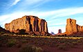
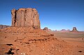
 West-southwest aspect | |
| Highest point | |
| Elevation | 5,981 ft (1,823 m) [1] |
| Prominence | 681 ft (208 m) [1] |
| Parent peak | Mitchell Mesa (6,586 ft) [1] |
| Isolation | 1.42 mi (2.29 km) [1] |
| Coordinates | 36°57′42″N110°04′41″W / 36.9616625°N 110.0781697°W [2] |
| Geography | |
 Elephant Butte Location in Arizona  Elephant Butte Elephant Butte (the United States) | |
| Location | Monument Valley Navajo County, Arizona, U.S. |
| Parent range | Colorado Plateau |
| Topo map | USGS Mitten Buttes |
| Geology | |
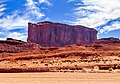
| Mountain type | Butte |
| Rock type | Sandstone |
Elephant Butte is a 5,981-foot-elevation (1,823-meter) summit in Navajo County, Arizona, United States.