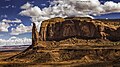
Spearhead Mesa

Last updated
Spearhead Mesa
Spearhead Mesa, south.jpg
South aspect
Highest point
Elevation 5,998 ft (1,828 m) [1]
Prominence 738 ft (225 m) [1]
Parent peak Mitchell Mesa (6,586 ft) [1]
Isolation 2.50 mi (4.02 km) [1]
Coordinates 36°56′49″N110°03′06″W / 36.9468130°N 110.0516243°W / 36.9468130; -110.0516243 [2]
Geography
USA Arizona relief location map.svg
Red triangle with thick white border.svg
Spearhead Mesa
Location in Arizona
Usa edcp relief location map.png
Red triangle with thick white border.svg
Spearhead Mesa
Spearhead Mesa (the United States)
Location Navajo Reservation
Navajo County, Arizona, U.S.
Parent range Colorado Plateau [3]
Topo map USGS Mitten Buttes
Geology
Mountain type Mesa
Type of rock Sandstone

Spearhead Mesa is a 5,998-foot-elevation (1,828-meter) summit in Navajo County, Arizona, United States.

Contents

Description

Spearhead Mesa is situated four miles (6.4 km) southeast of the Monument Valley visitor center on Navajo Nation land. The nearest higher neighbor is the iconic East Mitten Butte, 2.5 miles (4.0 km) to the north-northwest. [3] Precipitation runoff from this mesa's slopes drains into Gypsum Creek which is a tributary of the San Juan River. Topographic relief is significant as the summit rises 900 feet (274 meters) above the surrounding terrain in one-quarter mile (0.4 km). The landform's toponym has been officially adopted by the U.S. Board on Geographic Names. [2] The spearhead name refers to a sandstone spire above Artist Point that resembles the spear of an arrow. [4]

Geology

Spearhead Mesa is a mesa composed of three principal strata. The bottom layer is slope-forming Organ Rock Shale, the next stratum is cliff-forming De Chelly Sandstone, and the upper layer is Moenkopi Formation with a Shinarump Conglomerate caprock. The rock ranges in age from Permian at the bottom to Late Triassic at the top. The buttes and mesas of Monument Valley are the result of the Organ Rock Shale being more easily eroded than the overlaying sandstone. [5]

Climate

Spring and fall are the most favorable seasons to visit Spearhead Mesa. According to the Köppen climate classification system, it is located in a semi-arid climate zone with cold winters and hot summers. Summers average 54 days above 90 °F (32 °C) annually, and highs rarely exceed 100 °F (38 °C). Summer nights are comfortably cool, and temperatures drop quickly after sunset. Winters are cold, but daytime highs are usually above freezing. Winter temperatures below 0 °F (−18 °C) are uncommon, though possible. This desert climate receives less than 10 inches (250 millimeters) of annual rainfall, and snowfall is generally light during the winter. [6]

See also

Related Research Articles

<span class="mw-page-title-main">Monument Valley</span> Region of the Colorado Plateau, US

Monument Valley is a region of the Colorado Plateau characterized by a cluster of sandstone buttes, with the largest reaching 1,000 ft (300 m) above the valley floor. The most famous butte formations are located in northeastern Arizona along the Utah–Arizona state line. The valley is considered sacred by the Navajo Nation, the Native American people within whose reservation it lies.

<span class="mw-page-title-main">West and East Mitten Buttes</span> Buttes in Arizona, United States

The West and East Mitten Buttes are two buttes in the Monument Valley Navajo Tribal Park in northeast Navajo County, Arizona. When viewed from the south, the buttes appear to be two giant mittens with their thumbs facing inwards.

<span class="mw-page-title-main">Owl Rock</span> Landform in Navajo County, Arizona

Owl Rock is a 6,547-foot elevation sandstone summit located south of Monument Valley, in northeast Arizona. It is situated 7 miles (11 km) north of Kayenta on Navajo Nation land, and can be seen from Highway 163 perched on the east edge of Tyende Mesa, where it towers 1,000 feet above the surrounding terrain. Its nearest higher neighbor is Agathla Peak, 1.4 miles (2.3 km) to the east-northeast, on the opposite side of this highway. Precipitation runoff from this feature drains into El Capitan Wash, which is part of the San Juan River drainage basin. The first ascent of Owl Rock was made in April 1966 by Fred Beckey and Harvey Carter by climbing cracks on the west face, and then bolting up a smooth south nose to the summit. They employed 20 pitons and 14 bolts on this route called Warpath. The descriptive name stems from its uncanny resemblance to an owl when viewed from the east. This feature is known as Bee 'Adizí in Navajo language meaning "spindle", and this sacred place is considered to be a spindle left behind by the Holy People. A newer name for it is Tsé Ts'óózí, meaning "Slim Rock".

<span class="mw-page-title-main">Bridger Jack Butte</span> Rock formation in Utah, United States

Bridger Jack Butte is a sandstone butte located in Bears Ears National Monument, in San Juan County, Utah, United States. Set at the northern tip of Bridger Jack Mesa and above the confluence of Indian and Lavender Creeks, the summit rises to an elevation of 5,890 feet, and towers over 700 feet above the surrounding terrain and floor of Lavender Canyon to its west. This landmark is situated four miles southeast of the Sixshooter Peaks, and is visible from State Route 211 between Newspaper Rock and the Needles District of Canyonlands National Park. "Bridger Jack" was a Paiute medicine man.

<span class="mw-page-title-main">Gregory Butte</span> Butte in Utah, United States

Gregory Butte is a 4,651-foot elevation sandstone summit located in Glen Canyon National Recreation Area, in San Juan County of southern Utah. It is situated 7.3 miles (11.7 km) northeast of Tower Butte, and 16 miles (26 km) northeast of the town of Page. This iconic landmark of the Lake Powell area towers nearly 1,000 feet above the lake. Before Lake Powell was formed in the 1970s, this butte was set within a meander of the Colorado River. Gregory Butte is a butte composed of Entrada Sandstone. This sandstone, which was originally deposited as sandy mud on a tidal flat, is believed to have formed about 160 million years ago during the Jurassic period as a giant sand sea, the largest in Earth's history. This geographical feature's name was officially adopted in 1977 by the U.S. Board on Geographic Names. Geologist Herbert E. Gregory (1869–1952), mapped much of the bedrock geology of the Colorado Plateau, particularly in geologic monographs concentrating on what is now Navajo Nation land in northern Arizona and southern Utah where this butte is located. According to the Köppen climate classification system, Gregory Butte is located in an arid climate zone with hot, very dry summers, and chilly winters with very little snow.

<span class="mw-page-title-main">Boundary Butte (Rainbow Plateau)</span> Butte on the Rainbow Plateau in San Juan County, Utah, United States

Boundary Butte is a 4,934-foot elevation sandstone summit located south of Lake Powell, in extreme southwestern San Juan County, Utah, United States, just north of the Arizona border. It is situated on Navajo Nation land, 11.5 miles (18.5 km) northeast of the town of Page, and towers 1,200 feet above the lake as a landmark of the area. It lies on the Utah-Arizona border, hence its name.

<span class="mw-page-title-main">LeChee Rock</span> Landform in Coconino County, Arizona

LeChee Rock is a 5,900-foot-elevation (1,800 m) sandstone feature located south of Lake Powell, in Coconino County of northern Arizona. It is situated nine miles (14 km) east-southeast of the town of Page, eight miles (13 km) east of the community of LeChee, and 7.5 miles (12.1 km) south of Tower Butte, on Navajo Nation land, where it towers over 900 feet (270 m) above the surrounding terrain as a landmark of the area. It can be seen from nearby Arizona State Route 98, or from as far away as Alstrom Point. LeChee (Łichíí) in Navajo language means red, referring to burgundy-colored leaves of a medicinal plant. The spelling for this geographical feature's name was officially adopted in 2004 by the U.S. Board on Geographic Names, prior to that it was officially Leche-e Rock.

<span class="mw-page-title-main">Chaistla Butte</span> Landform in Navajo County, Arizona

Chaistla Butte is a 6,098-foot (1,859 m) elevation summit located south of Monument Valley, in Navajo County of northeast Arizona. It is situated 4.5 miles (7.2 km) northeast of the community of Kayenta, on Navajo Nation land, and can be seen from Highway 163. It is one of the eroded volcanic plugs, or diatremes, of the Navajo Volcanic Field, which is a volcanic field that includes intrusions and flows of minette and other unusual igneous rocks which formed around 30 million years ago during the Oligocene. Chaistla Butte rises 400 feet above the Little Capitan Valley, and the 1,000 by 700-foot base pokes up from the Chinle Formation. Its neighbors include Agathla Peak and Owl Rock, three miles (4.8 km) to the north-northwest. Precipitation runoff from this feature drains into the Laguña Creek drainage basin. The chaistla name, which means "beaver pocket" or "beaver corner" in the Navajo language, was officially adopted in 1915 by the U.S. Board on Geographic Names. Navajo teachings have its name meaning "to support the sky's underside", such that if this butte were to fall, the world would end. It is also known as Turkey Butte.

<span class="mw-page-title-main">Chimney Rock (Jackson Butte)</span> Butte in Montezuma County, Colorado, United States

Chimney Rock is a 6,110-foot (1,860 meter) elevation pillar located within the Ute Mountain Tribal Park, in Montezuma County of southwest Colorado. This landmark is situated one mile southeast of the junction of U.S. Route 491 and US 160, and towers 900 feet above the floor of the Mancos River Valley. This geographical feature is also known as Jackson Butte, named for William Henry Jackson (1843–1942), photographer and explorer famous for his images of the American West who visited this area during the Hayden Survey. He was the first to photograph the cliff dwellings in this Mesa Verde region of the Four Corners area.

<span class="mw-page-title-main">Square Butte (Arizona)</span> Landform in Coconino County, Navajo Nation, Arizona

Square Butte is a 7,140-foot-elevation (2,180 m) sandstone summit located on Navajo Nation land, in Coconino County of northern Arizona. It is situated 35 miles southeast of the town of Page, and nine miles (14 km) east of Kaibito, where it towers over 700 feet (210 m) above the surrounding terrain as a landmark alongside Arizona State Route 98. Square Butte is known as Tsé Dikʼání in Navajo language, meaning "square rock." Its nearest higher neighbor is White Mesa, two miles (3.2 km) to the south. Precipitation runoff from Square Butte drains to northwest into Square Butte Wash or northeast into Potato Canyon, then ultimately Lake Powell, all part of the Colorado River drainage basin. According to the Köppen climate classification system, Square Butte is located in an arid climate zone with hot, very dry summers, and chilly winters. Spring and fall are the most favorable seasons to visit. The top of Square Butte is composed of Entrada Sandstone including the Cow Springs Member, and it overlays Carmel Formation, all of which was deposited in the Jurassic period.

<span class="mw-page-title-main">Angels Gate</span> Landform in the Grand Canyon, Arizona

Angels Gate is a 6,761-foot (2,061 m)-elevation summit located in the Grand Canyon, in Coconino County of Arizona, United States. It is situated seven miles (11 km) due north of the Grandview Point overlook on the canyon's South Rim, three miles (4.8 km) west of Vishnu Temple, and three point five miles (5.6 km) southeast of Zoroaster Temple. Topographic relief is significant as it rises over 4,200 feet (1,300 m) above the Colorado River in three miles. Angels Gate is the place in Paiute mythology where the gods would return to Earth by descending from the shadow world above.

<span class="mw-page-title-main">Navajo Church</span>

Navajo Church is a 7,350-foot-elevation (2,240-meter) pillar in McKinley County, New Mexico, United States.

<span class="mw-page-title-main">Sentinel Mesa</span> Mountain in Utah, United States

Sentinel Mesa is a 6,450-foot-elevation (1,966-meter) summit in San Juan County, Utah, United States. It is situated 1.5 miles (2.4 km) north of the Monument Valley visitor center on Navajo Nation land and can be seen from Highway 163. The mesa is immediately northwest of the iconic West and East Mitten Buttes. The nearest higher neighbor is Brighams Tomb, 2.64 miles (4.25 km) to the north-northeast. Precipitation runoff from this mesa's west slope drains to Mitchell Butte Wash, whereas the east slope drains to West Gypsum Creek, which are both part of the San Juan River drainage basin. The "Sentinel" name refers to how the mesa oversees Monument Valley which the Navajo consider as one of the "door posts" to Monument Valley. The landform's toponym has been officially adopted by the U.S. Board on Geographic Names.

<span class="mw-page-title-main">Eagle Mesa</span> Mountain in Utah, United States

Eagle Mesa is a 6,624-foot-elevation (2,019-meter) summit in San Juan County, Utah, United States.

<span class="mw-page-title-main">Brighams Tomb</span>

Brighams Tomb is a 6,739-foot-elevation (2,054-meter) summit in San Juan County, Utah, United States.

Mitchell Mesa is a 6,586-foot-elevation (2,007-meter) summit in Navajo County, Arizona, United States.

<span class="mw-page-title-main">Rain God Mesa</span> Mountain in Arizona, United States

Rain God Mesa is a 5,921-foot-elevation (1,805-meter) summit in Navajo County, Arizona, United States.

<span class="mw-page-title-main">Camel Butte</span> Mountain in Arizona, United States

Camel Butte is a 5,847-foot-elevation (1,782-meter) summit in Navajo County, Arizona, United States.

<span class="mw-page-title-main">Elephant Butte (Monument Valley)</span> Mountain in Arizona, United States

Elephant Butte is a 5,981-foot-elevation (1,823-meter) summit in Navajo County, Arizona, United States.

<span class="mw-page-title-main">Cly Butte</span> Mountain in Arizona, United States

Cly Butte is a 5,820-foot-elevation (1,774-meter) summit in Navajo County, Arizona, United States.

References

  1. 1 2 3 4 "Spearhead Mesa - 5,998' AZ". listsofjohn.com. Retrieved 2024-08-26.
  2. 1 2 "Spearhead Mesa". Geographic Names Information System . United States Geological Survey, United States Department of the Interior . Retrieved 2024-08-26.
  3. 1 2 "Spearhead Mesa, Peakvisor.com" . Retrieved 2024-08-26.
  4. Monument Valley, City of Aztec, aztecnm.com, Retrieved 2024-08-26.
  5. Monument Valley, Arizona, Arizona Geological Survey, Retrieved 2024-08-24.
  6. Climate Summary for Kayenta, Arizona