Rain God Mesa

Last updated
Rain God Mesa
Rain God Mesa viewed from Artist's Point (45790665714).jpg
Northeast aspect
Highest point
Elevation 5,921 ft (1,805 m) [1]
Prominence 621 ft (189 m) [1]
Parent peak Mitchell Mesa (6,586 ft) [1]
Isolation 1.22 mi (1.96 km) [1]
Coordinates 36°56′32″N110°04′26″W / 36.9423209°N 110.0740231°W / 36.9423209; -110.0740231 [2]
Geography
USA Arizona relief location map.svg
Red triangle with thick white border.svg
Rain God Mesa
Location in Arizona
Usa edcp relief location map.png
Red triangle with thick white border.svg
Rain God Mesa
Rain God Mesa (the United States)
Location Navajo Nation
Navajo County, Arizona, U.S.
Parent range Colorado Plateau [3]
Topo map USGS Mitten Buttes
Geology
Mountain type Mesa
Type of rock Sandstone

Rain God Mesa is a 5,921-foot-elevation (1,805-meter) summit in Navajo County, Arizona, United States.

Contents

Description

Rain God Mesa is situated 3.5 miles (5.6 km) southeast of the Monument Valley visitor center on Navajo Nation land. Precipitation runoff from this mesa's slopes drains into Gypsum Creek which is a tributary of the San Juan River. Topographic relief is significant as the summit rises 600 feet (183 meters) above the surrounding terrain in one-quarter mile (0.4 km). The nearest higher neighbor is Elephant Butte, 1.4 miles (2.3 km) to the north-northwest. [3] The landform's toponym has been officially adopted by the U.S. Board on Geographic Names. [2] The name refers to Navajo medicine men praying and giving thanks to the Rain God, who provides water. Streaks from water that seeps out at the base of the sandstone can be seen on the south side of the mesa. [4]

Geology

Rain God Mesa is a mesa composed of three principal strata. The bottom layer is slope-forming Organ Rock Shale, the next stratum is cliff-forming De Chelly Sandstone, and the upper layer is Moenkopi Formation with a Shinarump Conglomerate caprock. The rock ranges in age from Permian at the bottom to Late Triassic at the top. The buttes and mesas of Monument Valley are the result of the Organ Rock Shale being more easily eroded than the overlaying sandstone. [5]

Climate

Spring and fall are the most favorable seasons to visit Rain God Mesa. According to the Köppen climate classification system, it is located in a semi-arid climate zone with cold winters and hot summers. Summers average 54 days above 90 °F (32 °C) annually, and highs rarely exceed 100 °F (38 °C). Summer nights are comfortably cool, and temperatures drop quickly after sunset. Winters are cold, but daytime highs are usually above freezing. Winter temperatures below 0 °F (−18 °C) are uncommon, though possible. This desert climate receives less than 10 inches (250 millimeters) of annual rainfall, and snowfall is generally light during the winter. [6]

See also

Related Research Articles

<span class="mw-page-title-main">Painted Desert (Arizona)</span> Desert in Arizona

The Painted Desert is a United States desert of badlands in the Four Corners area, running from near the east end of Grand Canyon National Park and southeast into Petrified Forest National Park. It is most easily accessed from the north portion of Petrified Forest National Park. The Painted Desert is known for its brilliant and varied colors: these include the more common red rock, but also shades of lavender.

<span class="mw-page-title-main">Mesa</span> Elevated area of land with a flat top and sides, usually much wider than buttes

A mesa is an isolated, flat-topped elevation, ridge or hill, which is bounded from all sides by steep escarpments and stands distinctly above a surrounding plain. Mesas characteristically consist of flat-lying soft sedimentary rocks capped by a more resistant layer or layers of harder rock, e.g. shales overlain by sandstones. The resistant layer acts as a caprock that forms the flat summit of a mesa. The caprock can consist of either sedimentary rocks such as sandstone and limestone; dissected lava flows; or a deeply eroded duricrust. Unlike plateau, whose usage does not imply horizontal layers of bedrock, e.g. Tibetan Plateau, the term mesa applies exclusively to the landforms built of flat-lying strata. Instead, flat-topped plateaus are specifically known as tablelands.

<span class="mw-page-title-main">Monument Valley</span> Region of the Colorado Plateau, US

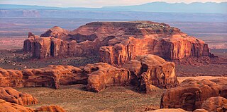
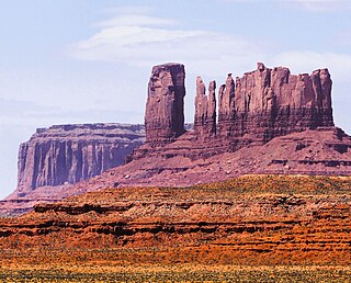
Monument Valley is a region of the Colorado Plateau characterized by a cluster of sandstone buttes, with the largest reaching 1,000 ft (300 m) above the valley floor. The most famous butte formations are located in northeastern Arizona along the Utah–Arizona state line. The valley is considered sacred by the Navajo Nation, the Native American people within whose reservation it lies.

<span class="mw-page-title-main">Geology of the Capitol Reef area</span>

The exposed geology of the Capitol Reef area presents a record of mostly Mesozoic-aged sedimentation in an area of North America in and around Capitol Reef National Park, on the Colorado Plateau in southeastern Utah.

<span class="mw-page-title-main">Grand Mesa</span> Mountain in Colorado, US

The Grand Mesa is a large mesa in western Colorado in the United States. It is the largest flat-topped mountain in the world. It has an area of about 500 square miles (1,300 km2) and stretches for about 40 miles (60 km) east of Grand Junction between the Colorado River and the Gunnison River, its tributary to the south. The north side of the mesa is drained largely by Plateau Creek, a smaller tributary of the Colorado. The west side is drained largely by Kannah Creek, which is received to the west by the lower Gunnison River. The mesa rises about 6,000 feet (1,800 m) above the surrounding river valleys, including the Grand Valley to the west, reaching an elevation of about 11,000 feet (3,400 m). Much of the mesa is within Grand Mesa National Forest. Over 300 lakes, including many reservoirs created and used for drinking and irrigation water, are scattered along the top of the formation. The Grand Mesa is flat in some areas, but quite rugged in others.

<span class="mw-page-title-main">Ute Mountain</span> Mountain in Colorado, US

Ute Mountain, also known as Ute Peak or Sleeping Ute Mountain, is a peak within the Ute Mountains, a small mountain range in the southwestern corner of Colorado. It is on the northern edge of the Ute Mountain Ute Tribe Reservation. The Reservation forms the southwestern corner of the state and of Montezuma County.

<span class="mw-page-title-main">West and East Mitten Buttes</span> Buttes in Arizona, United States

The West and East Mitten Buttes are two buttes in the Monument Valley Navajo Tribal Park in northeast Navajo County, Arizona. When viewed from the south, the buttes appear to be two giant mittens with their thumbs facing inwards.

<span class="mw-page-title-main">Owl Rock</span> Landform in Navajo County, Arizona

Owl Rock is a 6,547-foot elevation sandstone summit located south of Monument Valley, in northeast Arizona. It is situated 7 miles (11 km) north of Kayenta on Navajo Nation land, and can be seen from Highway 163 perched on the east edge of Tyende Mesa, where it towers 1,000 feet above the surrounding terrain. Its nearest higher neighbor is Agathla Peak, 1.4 miles (2.3 km) to the east-northeast, on the opposite side of this highway. Precipitation runoff from this feature drains into El Capitan Wash, which is part of the San Juan River drainage basin. The first ascent of Owl Rock was made in April 1966 by Fred Beckey and Harvey Carter by climbing cracks on the west face, and then bolting up a smooth south nose to the summit. They employed 20 pitons and 14 bolts on this route called Warpath. The descriptive name stems from its uncanny resemblance to an owl when viewed from the east. This feature is known as Bee 'Adizí in Navajo language meaning "spindle", and this sacred place is considered to be a spindle left behind by the Holy People. A newer name for it is Tsé Ts'óózí, meaning "Slim Rock".

<span class="mw-page-title-main">Navajo Church</span>

Navajo Church is a 7,350-foot-elevation (2,240-meter) pillar in McKinley County, New Mexico, United States.

<span class="mw-page-title-main">Sentinel Mesa</span> Mountain in Utah, United States

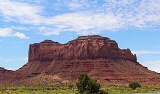
Sentinel Mesa is a 6,450-foot-elevation (1,966-meter) summit in San Juan County, Utah, United States. It is situated 1.5 miles (2.4 km) north of the Monument Valley visitor center on Navajo Nation land and can be seen from Highway 163. The mesa is immediately northwest of the iconic West and East Mitten Buttes. The nearest higher neighbor is Brighams Tomb, 2.64 miles (4.25 km) to the north-northeast. Precipitation runoff from this mesa's west slope drains to Mitchell Butte Wash, whereas the east slope drains to West Gypsum Creek, which are both part of the San Juan River drainage basin. The "Sentinel" name refers to how the mesa oversees Monument Valley which the Navajo consider as one of the "door posts" to Monument Valley. The landform's toponym has been officially adopted by the U.S. Board on Geographic Names.

<span class="mw-page-title-main">Eagle Mesa</span> Mountain in Utah, United States

Eagle Mesa is a 6,624-foot-elevation (2,019-meter) summit in San Juan County, Utah, United States.

<span class="mw-page-title-main">Brighams Tomb</span>

Brighams Tomb is a 6,739-foot-elevation (2,054-meter) summit in San Juan County, Utah, United States.

Mitchell Mesa is a 6,586-foot-elevation (2,007-meter) summit in Navajo County, Arizona, United States.

<span class="mw-page-title-main">Spearhead Mesa</span> Mountain in Arizona, United States

Spearhead Mesa is a 5,998-foot-elevation (1,828-meter) summit in Navajo County, Arizona, United States.

<span class="mw-page-title-main">Camel Butte</span> Mountain in Arizona, United States

Camel Butte is a 5,847-foot-elevation (1,782-meter) summit in Navajo County, Arizona, United States.

<span class="mw-page-title-main">Elephant Butte (Monument Valley)</span> Mountain in Arizona, United States

Elephant Butte is a 5,981-foot-elevation (1,823-meter) summit in Navajo County, Arizona, United States.

<span class="mw-page-title-main">Cly Butte</span> Mountain in Arizona, United States

Cly Butte is a 5,820-foot-elevation (1,774-meter) summit in Navajo County, Arizona, United States.

<span class="mw-page-title-main">Setting Hen</span>

Setting Hen is a 6,293-foot-elevation (1,918-meter) summit in San Juan County, Utah, United States.

<span class="mw-page-title-main">Mitchell Butte</span> Mountain in Arizona, United States

Mitchell Butte is a 6,383-foot-elevation (1,946-meter) summit in Navajo County, Arizona, United States.

<span class="mw-page-title-main">Gray Whiskers</span> Mountain in Arizona, United States

Gray Whiskers is a 6,385-foot-elevation (1,946-meter) summit in Navajo County, Arizona, United States.

References

  1. 1 2 3 4 "Rain God Mesa - 5,921' AZ". listsofjohn.com. Retrieved 2024-08-26.
  2. 1 2 "Rain God Mesa". Geographic Names Information System . United States Geological Survey, United States Department of the Interior . Retrieved 2024-08-26.
  3. 1 2 "Rain God Mesa, Peakvisor.com" . Retrieved 2024-08-26.
  4. Monument Valley, City of Aztec, aztecnm.com, Retrieved 2024-08-26.
  5. Monument Valley, Arizona, Arizona Geological Survey, Retrieved 2024-08-24.
  6. Climate Summary for Kayenta, Arizona